|
|
|||||||||||||||||
| Point ID: 2754 | Downloads | Plots | Site Data | Code: 10AC005 |
|
|
|||||||||||||||||
| Download | |
|---|---|
| Site Descriptor Information | Site Time Series Data |
| Link to all available data | |
|
|
| View: | Statistics | Time Series |
| Units: | m3/s |
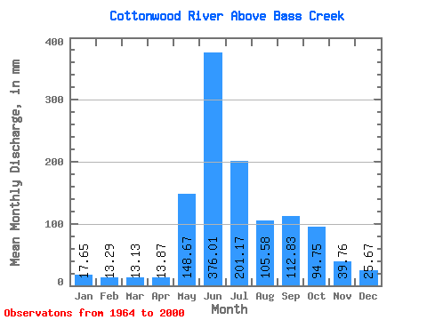
| Statistic | Jan | Feb | Mar | Apr | May | Jun | Jul | Aug | Sep | Oct | Nov | Dec | Annual |
|---|---|---|---|---|---|---|---|---|---|---|---|---|---|
| Mean | 9.84 | 7.47 | 7.32 | 7.73 | 82.86 | 209.60 | 112.12 | 58.85 | 62.90 | 52.81 | 22.17 | 14.31 | 646.92 |
| Standard Deviation | 1.78 | 1.60 | 1.48 | 2.17 | 40.54 | 49.52 | 41.50 | 20.93 | 25.99 | 22.48 | 5.42 | 2.24 | 96.69 |
| Min | 6.15 | 3.44 | 4.98 | 3.82 | 32.87 | 83.77 | 39.20 | 29.22 | 26.18 | 21.93 | 13.92 | 7.93 | 420.27 |
| Max | 14.11 | 11.76 | 11.19 | 12.32 | 227.69 | 309.40 | 215.33 | 110.68 | 125.81 | 137.22 | 36.49 | 20.36 | 837.57 |
| Coefficient of Variation | 0.18 | 0.21 | 0.20 | 0.28 | 0.49 | 0.24 | 0.37 | 0.36 | 0.41 | 0.43 | 0.24 | 0.16 | 0.15 |
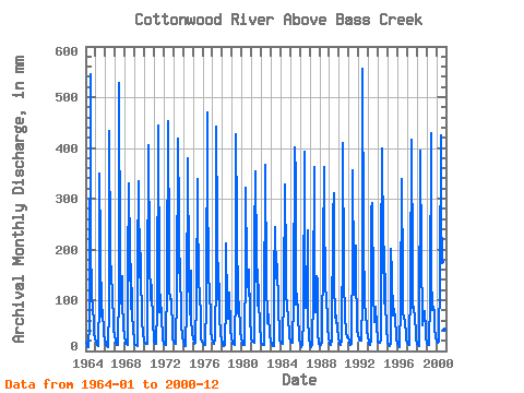
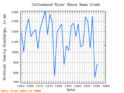
| Year | Jan | Feb | Mar | Apr | May | Jun | Jul | Aug | Sep | Oct | Nov | Dec | Annual | 1964 | 9.02 | 6.71 | 5.97 | 4.55 | 32.87 | 303.57 | 118.82 | 66.65 | 42.91 | 37.70 | 19.85 | 13.66 | 663.13 | 1965 | 10.68 | 7.58 | 6.85 | 5.69 | 57.30 | 194.40 | 117.31 | 38.90 | 43.49 | 47.05 | 19.96 | 11.94 | 560.41 | 1966 | 8.99 | 6.13 | 5.64 | 4.70 | 49.76 | 241.98 | 111.28 | 82.03 | 65.68 | 69.66 | 25.02 | 17.19 | 687.29 | 1967 | 12.43 | 8.38 | 7.09 | 6.68 | 68.16 | 294.81 | 104.04 | 53.98 | 81.73 | 55.19 | 26.45 | 16.95 | 736.84 | 1968 | 9.20 | 7.64 | 8.56 | 7.12 | 91.38 | 184.48 | 111.28 | 47.95 | 95.74 | 45.24 | 21.57 | 14.41 | 643.82 | 1969 | 7.99 | 6.46 | 7.00 | 5.52 | 105.25 | 186.81 | 83.54 | 110.68 | 87.28 | 35.89 | 17.89 | 14.27 | 666.89 | 1970 | 10.49 | 8.27 | 7.99 | 7.53 | 62.73 | 226.51 | 106.46 | 58.20 | 75.60 | 72.08 | 26.56 | 17.61 | 679.59 | 1971 | 10.74 | 7.67 | 7.69 | 7.30 | 49.16 | 247.82 | 70.27 | 43.73 | 61.59 | 34.98 | 18.94 | 14.11 | 575.37 | 1972 | 8.65 | 6.81 | 6.48 | 6.07 | 81.12 | 252.78 | 107.66 | 69.36 | 56.63 | 59.11 | 20.84 | 13.54 | 688.33 | 1973 | 10.40 | 8.74 | 8.78 | 7.76 | 65.14 | 232.93 | 152.00 | 88.66 | 101.58 | 28.80 | 16.17 | 15.89 | 736.16 | 1974 | 11.07 | 7.69 | 5.61 | 5.22 | 49.46 | 211.62 | 215.33 | 92.58 | 40.28 | 90.47 | 34.44 | 20.36 | 780.32 | 1975 | 13.06 | 9.18 | 8.56 | 8.52 | 59.11 | 188.56 | 164.96 | 76.90 | 63.05 | 38.00 | 13.92 | 10.80 | 652.70 | 1976 | 9.32 | 7.86 | 7.18 | 6.57 | 53.98 | 262.12 | 193.91 | 84.74 | 65.09 | 39.51 | 22.04 | 13.21 | 764.15 | 1977 | 11.04 | 9.43 | 8.56 | 12.32 | 88.36 | 246.65 | 141.44 | 59.41 | 73.56 | 41.32 | 16.90 | 12.43 | 720.76 | 1978 | 8.26 | 6.02 | 5.67 | 6.01 | 53.38 | 118.22 | 51.87 | 36.19 | 39.70 | 66.35 | 24.26 | 14.51 | 429.42 | 1979 | 9.11 | 6.98 | 7.57 | 6.66 | 71.78 | 238.18 | 151.09 | 42.52 | 43.49 | 54.59 | 21.31 | 14.45 | 666.50 | 1980 | 9.02 | 7.56 | 6.88 | 6.77 | 101.63 | 178.93 | 94.39 | 79.92 | 61.01 | 91.98 | 36.49 | 16.74 | 688.87 | 1981 | 14.11 | 10.14 | 10.46 | 9.28 | 125.15 | 197.03 | 104.04 | 51.27 | 89.03 | 57.90 | 27.35 | 13.96 | 708.50 | 1982 | 9.26 | 7.89 | 6.45 | 6.04 | 34.68 | 204.62 | 81.73 | 31.36 | 38.82 | 41.32 | 16.23 | 12.09 | 491.11 | 1983 | 10.68 | 7.17 | 5.55 | 5.69 | 85.95 | 136.02 | 84.44 | 82.33 | 94.86 | 48.85 | 19.50 | 11.76 | 591.22 | 1984 | 9.68 | 8.19 | 8.11 | 8.14 | 67.86 | 182.43 | 97.41 | 64.84 | 49.62 | 36.79 | 19.12 | 14.57 | 565.84 | 1985 | 11.97 | 8.90 | 9.68 | 9.57 | 57.00 | 223.59 | 197.53 | 52.78 | 63.34 | 41.32 | 15.18 | 12.06 | 701.33 | 1986 | 9.05 | 3.44 | 7.27 | 8.03 | 36.49 | 218.92 | 143.85 | 48.85 | 52.54 | 137.22 | 35.03 | 16.07 | 714.48 | 1987 | 6.51 | 4.45 | 5.22 | 6.13 | 63.93 | 202.57 | 122.14 | 43.43 | 82.61 | 80.22 | 19.29 | 7.93 | 643.43 | 1988 | 6.15 | 5.88 | 6.88 | 10.16 | 114.00 | 202.57 | 152.60 | 80.52 | 50.79 | 43.12 | 24.20 | 16.25 | 710.28 | 1989 | 8.54 | 6.21 | 7.39 | 10.80 | 155.61 | 173.09 | 74.79 | 42.52 | 30.94 | 39.81 | 23.50 | 16.47 | 587.46 | 1990 | 8.17 | 5.66 | 8.41 | 10.30 | 133.90 | 228.84 | 87.76 | 34.08 | 26.18 | 21.93 | 14.97 | 14.90 | 594.12 | 1991 | 10.16 | 9.29 | 6.67 | 8.17 | 117.31 | 198.19 | 88.97 | 64.24 | 115.59 | 91.68 | 24.02 | 16.59 | 749.58 | 1992 | 13.90 | 11.76 | 11.19 | 11.18 | 56.09 | 309.40 | 130.28 | 50.06 | 44.95 | 45.24 | 23.47 | 14.93 | 723.31 | 1993 | 10.44 | 7.01 | 7.30 | 11.36 | 160.14 | 162.29 | 66.95 | 32.57 | 32.98 | 50.36 | 28.46 | 12.73 | 580.47 | 1994 | 10.22 | 8.93 | 9.20 | 11.94 | 104.95 | 222.71 | 122.14 | 53.98 | 115.00 | 58.20 | 21.66 | 14.41 | 752.81 | 1995 | 9.53 | 6.16 | 5.61 | 8.58 | 115.20 | 83.77 | 40.41 | 42.22 | 45.83 | 35.28 | 17.16 | 12.43 | 420.27 | 1996 | 8.26 | 6.76 | 4.98 | 3.82 | 52.17 | 188.85 | 82.33 | 43.12 | 36.78 | 34.08 | 15.94 | 12.85 | 489.81 | 1997 | 8.72 | 7.14 | 6.51 | 6.51 | 73.28 | 231.47 | 94.69 | 49.46 | 48.45 | 37.09 | 21.16 | 13.54 | 598.03 | 1998 | 8.02 | 5.96 | 5.97 | 8.41 | 227.69 | 101.87 | 39.20 | 29.22 | 35.61 | 44.94 | 22.71 | 14.96 | 540.87 | 1999 | 9.56 | 6.98 | 6.48 | 7.04 | 59.11 | 239.35 | 86.25 | 47.05 | 49.04 | 43.43 | 24.93 | 15.47 | 595.13 | 2000 | 11.64 | 9.48 | 9.26 | 9.78 | 84.74 | 237.31 | 155.31 | 101.03 | 125.81 | 57.30 | 23.67 | 13.45 | 837.57 |
|---|
 Return to R-Arctic Net Home Page