|
|
|||||||||||||||||
| Point ID: 2751 | Downloads | Plots | Site Data | Code: 10AC002 |
|
|
|||||||||||||||||
| Download | |
|---|---|
| Site Descriptor Information | Site Time Series Data |
| Link to all available data | |
| View: | Time Series | All |
| Units: | m3/s |
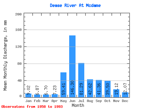
| Statistic | Jan | Feb | Mar | Apr | May | Jun | Jul | Aug | Sep | Oct | Nov | Dec | Annual |
|---|---|---|---|---|---|---|---|---|---|---|---|---|---|
| Mean | 9.01 | 6.93 | 6.70 | 7.23 | 59.40 | 146.30 | 81.28 | 42.61 | 41.36 | 39.49 | 19.12 | 12.07 | 466.28 |
| Standard Deviation | 1.62 | 1.21 | 1.31 | 2.13 | 23.43 | 36.79 | 27.96 | 14.93 | 14.07 | 16.84 | 6.92 | 2.69 | 64.01 |
| Min | 5.36 | 4.43 | 4.75 | 4.52 | 20.30 | 69.47 | 31.60 | 21.88 | 19.31 | 18.18 | 11.21 | 7.83 | 279.33 |
| Max | 13.39 | 9.53 | 10.11 | 12.81 | 111.91 | 224.84 | 150.11 | 80.65 | 79.55 | 104.57 | 37.72 | 19.14 | 581.93 |
| Coefficient of Variation | 0.18 | 0.17 | 0.20 | 0.29 | 0.39 | 0.25 | 0.34 | 0.35 | 0.34 | 0.43 | 0.36 | 0.22 | 0.14 |
 Return to R-Arctic Net Home Page