|
|
|||||||||||||||||
| Point ID: 2751 | Downloads | Plots | Site Data | Code: 10AC002 |
|
|
|||||||||||||||||
| Download | |
|---|---|
| Site Descriptor Information | Site Time Series Data |
| Link to all available data | |
| View: | Time Series | All |
| Units: | mm |
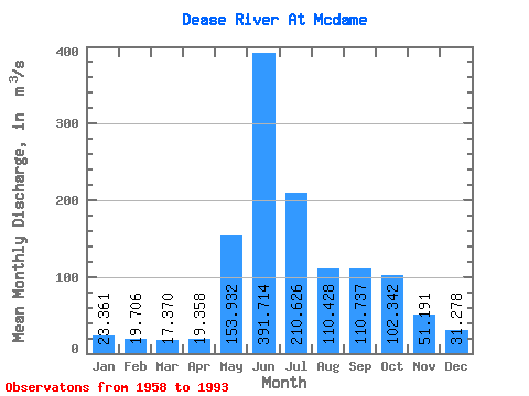
| Statistic | Jan | Feb | Mar | Apr | May | Jun | Jul | Aug | Sep | Oct | Nov | Dec | Annual |
|---|---|---|---|---|---|---|---|---|---|---|---|---|---|
| Mean | 23.36 | 19.71 | 17.37 | 19.36 | 153.93 | 391.71 | 210.63 | 110.43 | 110.74 | 102.34 | 51.19 | 31.28 | 102.53 |
| Standard Deviation | 4.20 | 3.45 | 3.38 | 5.70 | 60.72 | 98.50 | 72.45 | 38.68 | 37.66 | 43.65 | 18.52 | 6.97 | 14.07 |
| Min | 13.90 | 12.60 | 12.30 | 12.10 | 52.60 | 186.00 | 81.90 | 56.70 | 51.70 | 47.10 | 30.00 | 20.30 | 61.42 |
| Max | 34.70 | 27.10 | 26.20 | 34.30 | 290.00 | 602.00 | 389.00 | 209.00 | 213.00 | 271.00 | 101.00 | 49.60 | 127.97 |
| Coefficient of Variation | 0.18 | 0.17 | 0.20 | 0.29 | 0.39 | 0.25 | 0.34 | 0.35 | 0.34 | 0.43 | 0.36 | 0.22 | 0.14 |
 Return to R-Arctic Net Home Page