|
|
|||||||||||||||||
| Point ID: 2749 | Downloads | Plots | Site Data | Code: 09AE003 |
|
|
|||||||||||||||||
| Download | |
|---|---|
| Site Descriptor Information | Site Time Series Data |
| Link to all available data | |
| View: | Time Series | All |
| Units: | m3/s |
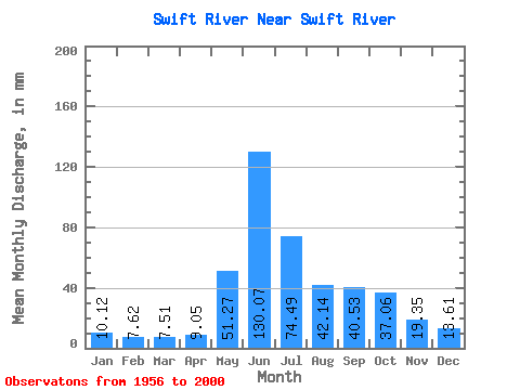
| Statistic | Jan | Feb | Mar | Apr | May | Jun | Jul | Aug | Sep | Oct | Nov | Dec | Annual |
|---|---|---|---|---|---|---|---|---|---|---|---|---|---|
| Mean | 10.12 | 7.69 | 7.51 | 9.05 | 51.26 | 130.07 | 74.47 | 42.14 | 40.53 | 37.05 | 19.35 | 13.61 | 443.63 |
| Standard Deviation | 2.15 | 1.94 | 1.55 | 3.38 | 18.64 | 34.57 | 26.47 | 14.78 | 16.18 | 14.10 | 4.48 | 2.96 | 72.86 |
| Min | 6.41 | 4.81 | 4.78 | 5.56 | 21.78 | 71.36 | 27.34 | 14.04 | 9.91 | 17.10 | 11.24 | 9.76 | 274.04 |
| Max | 17.02 | 15.51 | 11.86 | 23.42 | 89.54 | 206.89 | 131.48 | 87.12 | 87.44 | 83.89 | 29.82 | 22.26 | 566.48 |
| Coefficient of Variation | 0.21 | 0.25 | 0.21 | 0.37 | 0.36 | 0.27 | 0.35 | 0.35 | 0.40 | 0.38 | 0.23 | 0.22 | 0.16 |
 Return to R-Arctic Net Home Page