|
|
|||||||||||||||||
| Point ID: 2749 | Downloads | Plots | Site Data | Code: 09AE003 |
|
|
|||||||||||||||||
| Download | |
|---|---|
| Site Descriptor Information | Site Time Series Data |
| Link to all available data | |
|
|
| View: | Statistics | Time Series |
| Units: | m3/s |
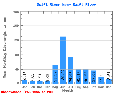
| Statistic | Jan | Feb | Mar | Apr | May | Jun | Jul | Aug | Sep | Oct | Nov | Dec | Annual |
|---|---|---|---|---|---|---|---|---|---|---|---|---|---|
| Mean | 10.12 | 7.69 | 7.51 | 9.05 | 51.26 | 130.07 | 74.47 | 42.14 | 40.53 | 37.05 | 19.35 | 13.61 | 443.63 |
| Standard Deviation | 2.15 | 1.94 | 1.55 | 3.38 | 18.64 | 34.57 | 26.47 | 14.78 | 16.18 | 14.10 | 4.48 | 2.96 | 72.86 |
| Min | 6.41 | 4.81 | 4.78 | 5.56 | 21.78 | 71.36 | 27.34 | 14.04 | 9.91 | 17.10 | 11.24 | 9.76 | 274.04 |
| Max | 17.02 | 15.51 | 11.86 | 23.42 | 89.54 | 206.89 | 131.48 | 87.12 | 87.44 | 83.89 | 29.82 | 22.26 | 566.48 |
| Coefficient of Variation | 0.21 | 0.25 | 0.21 | 0.37 | 0.36 | 0.27 | 0.35 | 0.35 | 0.40 | 0.38 | 0.23 | 0.22 | 0.16 |
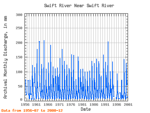
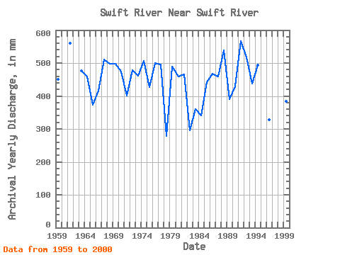
| Year | Jan | Feb | Mar | Apr | May | Jun | Jul | Aug | Sep | Oct | Nov | Dec | Annual | 1956 | 74.94 | 30.49 | 30.45 | 22.34 | 1957 | 72.11 | 28.15 | 21.70 | 23.80 | 21.63 | 13.96 | 1958 | 9.68 | 7.22 | 6.91 | 7.88 | 46.30 | 71.36 | 27.34 | 21.62 | 22.09 | 23.47 | 1959 | 6.69 | 5.21 | 5.45 | 6.52 | 51.14 | 121.79 | 51.78 | 78.08 | 49.97 | 40.73 | 21.47 | 13.31 | 451.05 | 1960 | 10.00 | 7.50 | 6.55 | 65.50 | 114.77 | 76.47 | 51.54 | 49.03 | 43.64 | 28.73 | 19.36 | 1961 | 13.23 | 8.67 | 7.93 | 7.88 | 80.34 | 176.44 | 89.54 | 46.46 | 55.67 | 40.73 | 17.64 | 15.97 | 559.69 | 1962 | 14.20 | 11.24 | 9.84 | 202.99 | 131.48 | 50.33 | 60.66 | 40.33 | 23.81 | 22.26 | 1963 | 17.02 | 15.51 | 11.86 | 8.74 | 61.71 | 125.70 | 97.60 | 31.38 | 38.41 | 37.43 | 19.13 | 12.10 | 475.78 | 1964 | 10.49 | 8.60 | 8.87 | 8.51 | 21.78 | 206.89 | 70.34 | 39.04 | 30.68 | 28.15 | 14.13 | 10.40 | 458.98 | 1965 | 8.31 | 6.48 | 6.20 | 5.56 | 36.62 | 109.30 | 68.81 | 30.01 | 40.75 | 34.20 | 17.49 | 9.92 | 373.21 | 1966 | 7.79 | 6.60 | 6.82 | 6.50 | 27.18 | 130.38 | 60.42 | 48.24 | 38.96 | 51.46 | 18.43 | 13.31 | 415.59 | 1967 | 11.21 | 8.82 | 8.47 | 8.67 | 54.29 | 191.28 | 78.81 | 38.64 | 37.16 | 38.23 | 19.13 | 16.70 | 511.42 | 1968 | 10.40 | 7.94 | 8.55 | 8.20 | 61.06 | 117.11 | 80.66 | 49.77 | 76.98 | 44.61 | 19.99 | 14.92 | 499.23 | 1969 | 8.87 | 4.95 | 4.78 | 6.91 | 61.95 | 110.08 | 61.30 | 87.12 | 81.98 | 35.57 | 19.91 | 16.05 | 498.12 | 1970 | 11.13 | 8.60 | 9.03 | 9.68 | 44.77 | 113.20 | 61.87 | 36.86 | 54.34 | 83.89 | 25.53 | 15.81 | 473.64 | 1971 | 10.40 | 8.82 | 8.55 | 8.82 | 40.33 | 145.21 | 50.90 | 34.28 | 35.84 | 28.64 | 17.10 | 11.54 | 400.84 | 1972 | 7.84 | 6.33 | 6.28 | 5.96 | 54.85 | 177.22 | 69.37 | 45.25 | 37.16 | 39.77 | 17.41 | 10.73 | 477.96 | 1973 | 7.07 | 6.08 | 7.50 | 9.53 | 49.20 | 135.85 | 83.89 | 61.47 | 51.45 | 26.78 | 13.43 | 9.84 | 461.23 | 1974 | 6.41 | 5.25 | 5.16 | 5.87 | 49.85 | 123.35 | 117.77 | 70.18 | 33.88 | 48.72 | 25.61 | 16.29 | 505.89 | 1975 | 10.40 | 5.98 | 5.64 | 6.14 | 38.80 | 110.86 | 106.47 | 45.57 | 37.94 | 30.73 | 16.47 | 13.07 | 426.58 | 1976 | 11.45 | 8.08 | 7.28 | 6.96 | 38.72 | 158.49 | 120.19 | 48.48 | 39.82 | 30.65 | 19.91 | 11.54 | 500.68 | 1977 | 12.02 | 9.63 | 8.07 | 13.12 | 58.80 | 156.15 | 95.18 | 43.88 | 39.74 | 32.51 | 16.86 | 10.57 | 495.90 | 1978 | 9.20 | 7.02 | 6.74 | 7.59 | 23.31 | 73.39 | 34.69 | 23.71 | 24.52 | 35.09 | 21.70 | 12.50 | 279.26 | 1979 | 9.20 | 6.06 | 6.86 | 7.12 | 44.77 | 151.46 | 125.03 | 40.65 | 30.06 | 38.96 | 18.66 | 13.31 | 490.65 | 1980 | 10.49 | 8.53 | 7.91 | 8.35 | 52.67 | 108.52 | 55.90 | 58.40 | 40.83 | 66.47 | 28.03 | 14.36 | 459.06 | 1981 | 12.10 | 9.11 | 10.00 | 8.67 | 89.54 | 109.30 | 59.53 | 34.77 | 57.85 | 42.43 | 21.31 | 12.26 | 465.80 | 1982 | 8.63 | 8.08 | 7.86 | 7.22 | 23.39 | 99.93 | 52.67 | 25.65 | 20.77 | 17.10 | 13.35 | 10.65 | 295.39 | 1983 | 8.47 | 6.20 | 6.13 | 6.67 | 37.91 | 99.93 | 47.11 | 35.41 | 49.73 | 35.90 | 17.10 | 10.57 | 360.90 | 1984 | 7.20 | 5.03 | 5.31 | 7.58 | 42.27 | 102.28 | 56.30 | 35.73 | 30.53 | 24.60 | 14.99 | 10.49 | 341.71 | 1985 | 9.12 | 7.29 | 7.37 | 6.62 | 38.31 | 135.85 | 105.67 | 38.88 | 37.40 | 31.14 | 13.74 | 11.37 | 441.82 | 1986 | 9.12 | 4.81 | 5.29 | 6.17 | 25.73 | 128.04 | 100.83 | 45.01 | 37.71 | 64.45 | 27.09 | 15.97 | 468.73 | 1987 | 12.58 | 9.70 | 8.79 | 10.07 | 46.78 | 143.65 | 89.54 | 35.90 | 34.35 | 38.07 | 16.63 | 14.12 | 459.54 | 1988 | 10.97 | 9.19 | 9.44 | 12.26 | 70.98 | 135.06 | 125.03 | 62.51 | 37.16 | 34.28 | 20.14 | 13.55 | 538.44 | 1989 | 10.40 | 7.72 | 8.23 | 18.04 | 80.66 | 85.10 | 45.90 | 34.36 | 28.03 | 36.06 | 19.91 | 17.42 | 390.46 | 1990 | 12.82 | 9.26 | 8.71 | 11.55 | 73.64 | 157.71 | 65.09 | 27.18 | 22.64 | 20.00 | 11.24 | 9.76 | 429.44 | 1991 | 8.87 | 7.57 | 7.42 | 11.48 | 76.39 | 132.72 | 63.88 | 48.40 | 87.44 | 73.08 | 29.82 | 20.33 | 566.48 | 1992 | 13.39 | 9.33 | 9.76 | 11.01 | 41.30 | 202.21 | 87.92 | 40.98 | 34.74 | 31.70 | 19.44 | 15.81 | 517.92 | 1993 | 11.78 | 8.67 | 8.31 | 23.42 | 88.73 | 100.71 | 51.06 | 29.84 | 31.70 | 42.75 | 26.55 | 15.24 | 437.67 | 1994 | 9.68 | 6.40 | 5.32 | 11.87 | 74.45 | 134.28 | 72.11 | 42.11 | 55.04 | 49.85 | 19.28 | 15.57 | 494.87 | 1996 | 10.32 | 7.94 | 7.65 | 8.43 | 35.01 | 92.91 | 48.88 | 34.77 | 30.29 | 22.34 | 15.69 | 14.60 | 328.50 | 1997 | 9.92 | 7.20 | 7.24 | 7.81 | 27.40 | 23.39 | 16.47 | 11.78 | 1998 | 8.47 | 6.37 | 6.44 | 8.28 | 72.60 | 71.44 | 28.31 | 14.04 | 9.91 | 19.60 | 17.18 | 12.26 | 274.04 | 1999 | 9.12 | 7.50 | 8.39 | 11.40 | 39.44 | 142.09 | 51.78 | 28.88 | 28.81 | 28.47 | 16.79 | 11.54 | 384.52 | 2000 | 8.47 | 6.33 | 6.47 | 8.90 | 29.28 | 128.04 | 87.92 | 57.92 | 61.60 | 28.31 | 13.97 | 10.32 | 447.05 |
|---|
 Return to R-Arctic Net Home Page