|
|
|||||||||||||||||
| Point ID: 229 | Downloads | Plots | Site Data | Code: 05BA007 |
|
|
|||||||||||||||||
| Download | |
|---|---|
| Site Descriptor Information | Site Time Series Data |
| Link to all available data | |
| View: | Time Series | All |
| Units: | m3/s |
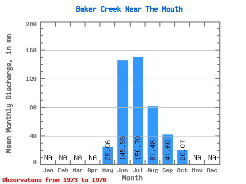
| Statistic | Jan | Feb | Mar | Apr | May | Jun | Jul | Aug | Sep | Oct | Nov | Dec | Annual |
|---|---|---|---|---|---|---|---|---|---|---|---|---|---|
| Mean | 25.05 | 145.56 | 150.67 | 81.47 | 41.60 | 20.06 | |||||||
| Standard Deviation | 2.14 | 52.88 | 36.58 | 32.29 | 24.05 | 4.29 | |||||||
| Min | 23.54 | 112.25 | 112.73 | 55.72 | 26.96 | 16.07 | |||||||
| Max | 26.56 | 206.52 | 185.73 | 128.50 | 77.34 | 26.13 | |||||||
| Coefficient of Variation | 0.09 | 0.36 | 0.24 | 0.40 | 0.58 | 0.21 |
 Return to R-Arctic Net Home Page