|
|
| Point ID: 229 | Downloads | Plots | Site Data | Code: 05BA007 |
|
| Download | |
|---|---|
| Site Descriptor Information | Site Time Series Data |
| Link to all available data | |
|
|
|
| View: | Statistics | All |
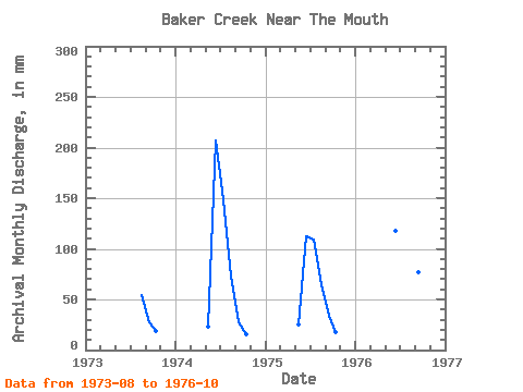
| Units: | m3/s |
| Year | Jan | Feb | Mar | Apr | May | Jun | Jul | Aug | Sep | Oct | Nov | Dec | Annual | 1973 | 55.72 | 27.80 | 19.39 | 1974 | 23.54 | 206.52 | 153.55 | 74.51 | 26.96 | 16.07 | 1975 | 26.56 | 112.25 | 112.73 | 67.17 | 34.28 | 18.64 | 1976 | 117.89 | 185.73 | 128.50 | 77.34 | 26.13 |
|---|
 Return to R-Arctic Net Home Page