|
|
| Point ID: 8761 | Downloads | Plots | Site Data | Code: 12036 |
|
| Download | |
|---|---|
| Site Descriptor Information | Site Time Series Data |
| Link to all available data | |
|
|
|
| View: | Statistics | All |
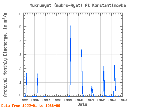
| Units: | mm |
| Year | Jan | Feb | Mar | Apr | May | Jun | Jul | Aug | Sep | Oct | Nov | Dec | Annual | 1955 | 0.00 | 0.00 | 0.00 | 1.64 | 0.00 | 0.00 | 1956 | 0.00 | 0.00 | 0.00 | 1.60 | 0.00 | 0.00 | 1959 | 0.00 | 0.00 | 5.04 | 1960 | 3.32 | 0.23 | 0.04 | 1961 | 0.00 | 0.71 | 0.32 | 0.06 | 0.01 | 1962 | 0.00 | 0.00 | 0.01 | 2.19 | 0.07 | 0.02 | 0.00 | 0.00 | 0.00 | 0.00 | 0.00 | 0.00 | 0.19 | 1963 | 0.00 | 0.00 | 0.00 | 2.22 | 0.43 | 0.00 | 0.00 | 0.00 | 0.00 |
|---|
 Return to R-Arctic Net Home Page