|
|
| Point ID: 8761 | Downloads | Plots | Site Data | Code: 12036 |
|
| Download | |
|---|---|
| Site Descriptor Information | Site Time Series Data |
| Link to all available data | |
|
|
|
| View: | Statistics | All |
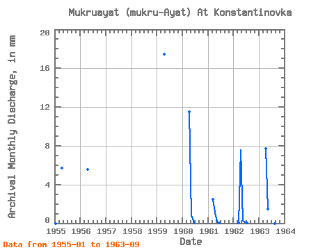
| Units: | m3/s |
| Year | Jan | Feb | Mar | Apr | May | Jun | Jul | Aug | Sep | Oct | Nov | Dec | Annual | 1955 | 0.00 | 0.00 | 0.00 | 5.68 | 0.00 | 0.00 | 1956 | 0.00 | 0.00 | 0.00 | 5.54 | 0.00 | 0.00 | 1959 | 0.00 | 0.00 | 17.46 | 1960 | 11.51 | 0.83 | 0.12 | 1961 | 0.00 | 2.54 | 1.11 | 0.21 | 0.04 | 1962 | 0.00 | 0.00 | 0.02 | 7.59 | 0.24 | 0.08 | 0.01 | 0.00 | 0.00 | 0.00 | 0.00 | 0.00 | 8.05 | 1963 | 0.00 | 0.00 | 0.00 | 7.69 | 1.54 | 0.00 | 0.00 | 0.00 | 0.00 |
|---|
 Return to R-Arctic Net Home Page