|
|
| Point ID: 9556 | Downloads | Plots | Site Data | Code: 05060570 |
|
| Download | |
|---|---|
| Site Descriptor Information | Site Time Series Data |
| Link to all available data | |
|
|
|
| View: | Statistics | All |
| Units: | m3/s |
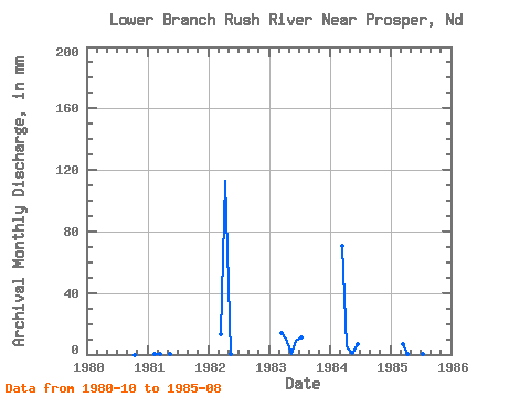
| Year | Jan | Feb | Mar | Apr | May | Jun | Jul | Aug | Sep | Oct | Nov | Dec | Annual | 1980 | 0.00 | 0.00 | 0.00 | 1981 | 0.00 | 0.18 | 0.33 | 0.00 | 0.03 | 0.00 | 0.00 | 0.00 | 0.00 | 1982 | 13.88 | 112.66 | 0.03 | 0.00 | 0.00 | 0.00 | 1983 | 14.68 | 10.38 | 0.51 | 9.06 | 11.82 | 0.00 | 1984 | 72.91 | 5.08 | 0.19 | 6.85 | 0.00 | 0.00 | 1985 | 7.05 | 0.26 | 24.49 | 1.44 | 0.03 | 0.00 |
|---|
 Return to R-Arctic Net Home Page