|
|
|||||||||||||||||
| Point ID: 6610 | Downloads | Plots | Site Data | Code: 9384 |
|
|
|||||||||||||||||
| Download | |
|---|---|
| Site Descriptor Information | Site Time Series Data |
| Link to all available data | |

|
|
| View: | Statistics | Time Series |
| Units: | mm |
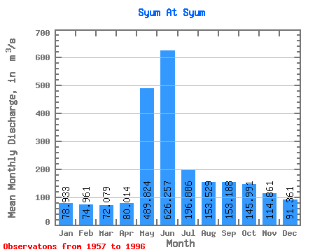
| Statistic | Jan | Feb | Mar | Apr | May | Jun | Jul | Aug | Sep | Oct | Nov | Dec | Annual |
|---|---|---|---|---|---|---|---|---|---|---|---|---|---|
| Mean | 78.93 | 74.96 | 72.08 | 80.01 | 489.82 | 626.26 | 196.89 | 153.53 | 153.19 | 145.99 | 114.86 | 91.36 | 189.19 |
| Standard Deviation | 15.64 | 11.68 | 8.69 | 13.03 | 157.32 | 235.34 | 56.36 | 46.01 | 50.28 | 47.62 | 33.19 | 22.11 | 25.70 |
| Min | 38.00 | 41.50 | 51.90 | 55.20 | 127.00 | 251.00 | 129.00 | 107.00 | 92.20 | 90.80 | 71.00 | 49.40 | 144.07 |
| Max | 132.00 | 101.00 | 86.80 | 120.00 | 794.00 | 1090.00 | 431.00 | 315.00 | 272.00 | 246.00 | 217.00 | 177.00 | 241.21 |
| Coefficient of Variation | 0.20 | 0.16 | 0.12 | 0.16 | 0.32 | 0.38 | 0.29 | 0.30 | 0.33 | 0.33 | 0.29 | 0.24 | 0.14 |
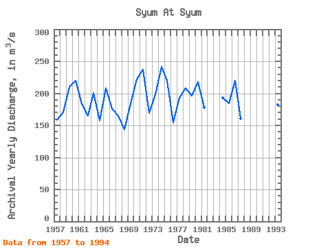
| Year | Jan | Feb | Mar | Apr | May | Jun | Jul | Aug | Sep | Oct | Nov | Dec | Annual | 1957 | 84.90 | 78.10 | 70.90 | 71.60 | 415.00 | 528.00 | 152.00 | 113.00 | 107.00 | 111.00 | 91.30 | 78.80 | 158.47 | 1958 | 73.20 | 75.90 | 72.70 | 66.70 | 415.00 | 583.00 | 136.00 | 116.00 | 131.00 | 157.00 | 138.00 | 81.10 | 170.47 | 1959 | 77.70 | 77.50 | 81.90 | 76.90 | 287.00 | 1010.00 | 208.00 | 150.00 | 169.00 | 148.00 | 136.00 | 103.00 | 210.42 | 1960 | 79.50 | 78.50 | 80.40 | 82.90 | 464.00 | 901.00 | 243.00 | 144.00 | 183.00 | 178.00 | 119.00 | 87.00 | 220.03 | 1961 | 82.20 | 76.60 | 69.60 | 85.80 | 540.00 | 575.00 | 161.00 | 169.00 | 142.00 | 122.00 | 92.60 | 84.80 | 183.38 | 1962 | 75.10 | 71.90 | 70.60 | 78.90 | 670.00 | 332.00 | 155.00 | 117.00 | 114.00 | 103.00 | 98.60 | 88.20 | 164.53 | 1963 | 86.20 | 94.90 | 86.80 | 85.10 | 381.00 | 861.00 | 188.00 | 136.00 | 123.00 | 130.00 | 128.00 | 105.00 | 200.42 | 1964 | 99.00 | 88.00 | 78.60 | 86.20 | 399.00 | 497.00 | 161.00 | 113.00 | 107.00 | 98.50 | 90.70 | 75.50 | 157.79 | 1965 | 75.30 | 76.00 | 76.10 | 81.20 | 395.00 | 658.00 | 257.00 | 195.00 | 256.00 | 190.00 | 135.00 | 96.50 | 207.59 | 1966 | 84.80 | 80.80 | 76.90 | 78.60 | 521.00 | 501.00 | 214.00 | 123.00 | 113.00 | 117.00 | 104.00 | 91.10 | 175.43 | 1967 | 79.80 | 70.60 | 71.20 | 120.00 | 740.00 | 251.00 | 144.00 | 107.00 | 108.00 | 111.00 | 95.50 | 85.40 | 165.29 | 1968 | 75.50 | 67.10 | 63.50 | 92.70 | 341.00 | 314.00 | 246.00 | 160.00 | 113.00 | 105.00 | 90.90 | 60.20 | 144.07 | 1969 | 57.80 | 57.70 | 54.40 | 55.20 | 256.00 | 899.00 | 189.00 | 156.00 | 159.00 | 118.00 | 106.00 | 98.50 | 183.88 | 1970 | 80.50 | 72.50 | 69.90 | 78.70 | 407.00 | 929.00 | 431.00 | 156.00 | 166.00 | 127.00 | 71.00 | 73.30 | 221.82 | 1971 | 65.30 | 72.30 | 64.70 | 86.60 | 794.00 | 596.00 | 186.00 | 134.00 | 228.00 | 228.00 | 217.00 | 177.00 | 237.41 | 1972 | 132.00 | 101.00 | 81.30 | 75.90 | 384.00 | 397.00 | 214.00 | 136.00 | 162.00 | 176.00 | 105.00 | 74.10 | 169.86 | 1973 | 68.20 | 62.30 | 60.60 | 58.90 | 397.00 | 847.00 | 195.00 | 215.00 | 119.00 | 140.00 | 112.00 | 100.00 | 197.92 | 1974 | 85.20 | 76.80 | 68.90 | 77.00 | 699.00 | 705.00 | 189.00 | 315.00 | 237.00 | 189.00 | 155.00 | 97.60 | 241.21 | 1975 | 70.00 | 62.50 | 62.50 | 80.10 | 361.00 | 839.00 | 214.00 | 187.00 | 272.00 | 230.00 | 143.00 | 122.00 | 220.26 | 1976 | 87.70 | 82.20 | 83.30 | 86.80 | 556.00 | 274.00 | 142.00 | 125.00 | 122.00 | 114.00 | 96.70 | 86.80 | 154.71 | 1977 | 76.30 | 68.80 | 65.40 | 87.20 | 751.00 | 290.00 | 156.00 | 121.00 | 207.00 | 210.00 | 159.00 | 118.00 | 192.47 | 1978 | 93.70 | 88.80 | 80.30 | 78.80 | 618.00 | 585.00 | 167.00 | 141.00 | 167.00 | 223.00 | 156.00 | 103.00 | 208.47 | 1979 | 91.30 | 81.10 | 68.60 | 72.60 | 646.00 | 743.00 | 184.00 | 127.00 | 114.00 | 103.00 | 74.20 | 49.40 | 196.18 | 1980 | 38.00 | 58.00 | 67.50 | 71.10 | 507.00 | 893.00 | 244.00 | 227.00 | 168.00 | 128.00 | 108.00 | 99.20 | 217.40 | 1981 | 94.20 | 93.00 | 86.00 | 108.00 | 660.00 | 389.00 | 154.00 | 137.00 | 123.00 | 105.00 | 91.00 | 89.00 | 177.43 | 1982 | 83.20 | 75.50 | 72.70 | 98.70 | 698.00 | 260.00 | 129.00 | 1983 | 71.10 | 68.60 | 127.00 | 1090.00 | 208.00 | 124.00 | 125.00 | 137.00 | 101.00 | 95.70 | 1984 | 84.50 | 79.80 | 79.90 | 80.30 | 538.00 | 590.00 | 320.00 | 161.00 | 118.00 | 98.40 | 89.20 | 81.00 | 193.34 | 1985 | 75.80 | 78.00 | 82.70 | 93.80 | 471.00 | 637.00 | 174.00 | 146.00 | 132.00 | 139.00 | 101.00 | 83.90 | 184.52 | 1986 | 77.20 | 78.40 | 75.10 | 76.40 | 352.00 | 792.00 | 191.00 | 251.00 | 191.00 | 246.00 | 195.00 | 120.00 | 220.43 | 1987 | 83.20 | 78.60 | 78.20 | 84.90 | 559.00 | 386.00 | 185.00 | 116.00 | 96.20 | 94.00 | 89.50 | 73.80 | 160.37 | 1988 | 69.10 | 66.20 | 62.50 | 57.10 | 377.00 | 734.00 | 197.00 | 113.00 | 92.20 | 90.80 | 82.90 | 77.80 | 168.30 | 1989 | 72.60 | 1993 | 69.50 | 62.80 | 64.00 | 65.60 | 360.00 | 621.00 | 183.00 | 159.00 | 180.00 | 235.00 | 122.00 | 70.20 | 182.68 | 1994 | 48.90 | 41.50 | 51.90 | 79.00 | 568.00 | 515.00 | 181.00 | 118.00 | 108.00 | 116.00 | 96.30 | 88.00 | 167.63 | 1996 | 897.00 | 193.00 | 212.00 | 256.00 |
|---|
 Return to R-Arctic Net Home Page