|
|
|||||||||||||||||
| Point ID: 6763 | Downloads | Plots | Site Data | Other Close Sites | Code: 10252 |
|
|
|||||||||||||||||
| Download | |
|---|---|
| Site Descriptor Information | Site Time Series Data |
| Link to all available data | |

|
|
| View: | Statistics | Time Series |
| Units: | m3/s |
| Statistic | Jan | Feb | Mar | Apr | May | Jun | Jul | Aug | Sep | Oct | Nov | Dec | Annual |
|---|---|---|---|---|---|---|---|---|---|---|---|---|---|
| Mean | 8.70 | 6.68 | 7.15 | 65.47 | 235.37 | 86.85 | 23.85 | 18.44 | 22.47 | 42.09 | 19.00 | 12.05 | 545.23 |
| Standard Deviation | 1.19 | 0.15 | 0.86 | 11.63 | 3.71 | 13.79 | 3.22 | 8.01 | 10.58 | 29.10 | 6.65 | 1.77 | 29.11 |
| Min | 7.69 | 6.54 | 6.44 | 56.05 | 231.66 | 77.58 | 20.85 | 11.21 | 11.97 | 22.47 | 12.91 | 10.98 | 520.95 |
| Max | 10.01 | 6.84 | 8.11 | 78.48 | 239.07 | 102.69 | 27.24 | 27.06 | 33.14 | 75.52 | 26.10 | 14.09 | 577.51 |
| Coefficient of Variation | 0.14 | 0.02 | 0.12 | 0.18 | 0.02 | 0.16 | 0.14 | 0.43 | 0.47 | 0.69 | 0.35 | 0.15 | 0.05 |
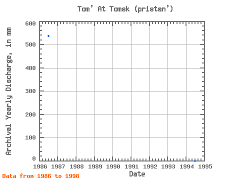
| Year | Jan | Feb | Mar | Apr | May | Jun | Jul | Aug | Sep | Oct | Nov | Dec | Annual | 1986 | 10.01 | 6.54 | 6.44 | 56.05 | 239.07 | 102.69 | 23.44 | 27.06 | 22.29 | 22.47 | 12.91 | 10.98 | 537.24 | 1987 | 8.39 | 6.84 | 6.90 | 61.88 | 231.66 | 80.27 | 27.24 | 17.05 | 33.14 | 75.52 | 17.98 | 14.09 | 577.51 | 1994 | 1998 | 7.69 | 6.67 | 8.11 | 78.48 | 235.37 | 77.58 | 20.85 | 11.21 | 11.97 | 28.26 | 26.10 | 11.07 | 520.95 |
|---|
| Other Close Sites | ||||||
|---|---|---|---|---|---|---|
| PointID | Latitude | Longitude | Drainage Area | Source | Name | |
| 6762 | "Tom' At Tomsk sk" | 56.50 | -325172 | SHI | 75.00 | |
 Return to R-Arctic Net Home Page
