|
|
|||||||||||||||||
| Point ID: 6763 | Downloads | Plots | Site Data | Other Close Sites | Code: 10252 |
|
|
|||||||||||||||||
| Download | |
|---|---|
| Site Descriptor Information | Site Time Series Data |
| Link to all available data | |
|
|
| View: | Statistics | Time Series |
| Units: | mm |
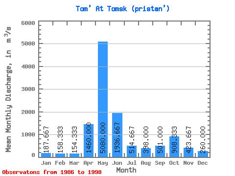
| Statistic | Jan | Feb | Mar | Apr | May | Jun | Jul | Aug | Sep | Oct | Nov | Dec | Annual |
|---|---|---|---|---|---|---|---|---|---|---|---|---|---|
| Mean | 187.67 | 158.33 | 154.33 | 1460.00 | 5080.00 | 1936.67 | 514.67 | 398.00 | 501.00 | 908.33 | 423.67 | 260.00 | 998.56 |
| Standard Deviation | 25.66 | 3.51 | 18.58 | 259.42 | 80.00 | 307.46 | 69.41 | 172.96 | 236.03 | 628.10 | 148.31 | 38.12 | 53.32 |
| Min | 166.00 | 155.00 | 139.00 | 1250.00 | 5000.00 | 1730.00 | 450.00 | 242.00 | 267.00 | 485.00 | 288.00 | 237.00 | 954.08 |
| Max | 216.00 | 162.00 | 175.00 | 1750.00 | 5160.00 | 2290.00 | 588.00 | 584.00 | 739.00 | 1630.00 | 582.00 | 304.00 | 1057.67 |
| Coefficient of Variation | 0.14 | 0.02 | 0.12 | 0.18 | 0.02 | 0.16 | 0.14 | 0.43 | 0.47 | 0.69 | 0.35 | 0.15 | 0.05 |
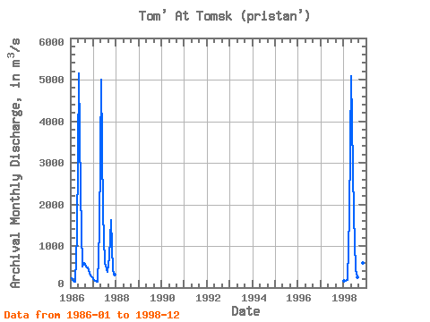
| Year | Jan | Feb | Mar | Apr | May | Jun | Jul | Aug | Sep | Oct | Nov | Dec | Annual | 1986 | 216.00 | 155.00 | 139.00 | 1250.00 | 5160.00 | 2290.00 | 506.00 | 584.00 | 497.00 | 485.00 | 288.00 | 237.00 | 983.92 | 1987 | 181.00 | 162.00 | 149.00 | 1380.00 | 5000.00 | 1790.00 | 588.00 | 368.00 | 739.00 | 1630.00 | 401.00 | 304.00 | 1057.67 | 1994 | 1998 | 166.00 | 158.00 | 175.00 | 1750.00 | 5080.00 | 1730.00 | 450.00 | 242.00 | 267.00 | 610.00 | 582.00 | 239.00 | 954.08 |
|---|
| Other Close Sites | ||||||
|---|---|---|---|---|---|---|
| PointID | Latitude | Longitude | Drainage Area | Source | Name | |
| 6762 | "Tom' At Tomsk sk" | 56.50 | -325172 | SHI | 75.00 | |
 Return to R-Arctic Net Home Page