|
|
|||||||||||||||||
| Point ID: 5172 | Downloads | Plots | Site Data | Other Close Sites | Code: 03KC004 |
|
|
|||||||||||||||||
| Download | |
|---|---|
| Site Descriptor Information | Site Time Series Data |
| Link to all available data | |
|
|
| View: | Statistics | Time Series |
| Units: | m3/s |
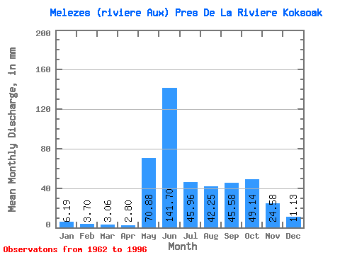
| Statistic | Jan | Feb | Mar | Apr | May | Jun | Jul | Aug | Sep | Oct | Nov | Dec | Annual |
|---|---|---|---|---|---|---|---|---|---|---|---|---|---|
| Mean | 6.19 | 3.73 | 3.06 | 2.80 | 70.87 | 141.70 | 45.95 | 42.24 | 45.58 | 49.13 | 24.58 | 11.12 | 451.90 |
| Standard Deviation | 1.71 | 1.16 | 1.07 | 1.05 | 45.39 | 55.98 | 16.34 | 25.92 | 15.32 | 13.73 | 9.17 | 3.06 | 64.14 |
| Min | 3.77 | 1.93 | 1.57 | 1.41 | 2.77 | 39.15 | 15.43 | 13.73 | 20.03 | 19.13 | 12.08 | 7.02 | 249.88 |
| Max | 10.66 | 6.97 | 6.46 | 6.07 | 150.52 | 253.13 | 74.63 | 137.35 | 91.66 | 70.24 | 52.08 | 18.69 | 556.45 |
| Coefficient of Variation | 0.28 | 0.31 | 0.35 | 0.38 | 0.64 | 0.40 | 0.36 | 0.61 | 0.34 | 0.28 | 0.37 | 0.28 | 0.14 |
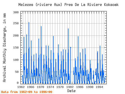
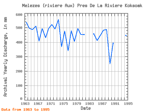
| Year | Jan | Feb | Mar | Apr | May | Jun | Jul | Aug | Sep | Oct | Nov | Dec | Annual | 1962 | 31.93 | 35.94 | 19.43 | 13.42 | 1963 | 8.03 | 3.87 | 2.43 | 3.30 | 47.79 | 193.03 | 60.77 | 63.34 | 71.02 | 39.07 | 31.63 | 12.98 | 537.75 | 1964 | 5.05 | 2.47 | 1.96 | 2.32 | 54.19 | 202.75 | 38.51 | 24.84 | 59.91 | 64.60 | 24.71 | 13.92 | 496.01 | 1965 | 7.34 | 3.91 | 2.72 | 2.05 | 36.69 | 253.13 | 48.17 | 40.33 | 33.81 | 33.11 | 15.54 | 9.28 | 487.66 | 1966 | 5.86 | 3.73 | 3.31 | 2.93 | 90.31 | 177.86 | 53.18 | 60.33 | 29.38 | 46.03 | 23.67 | 16.18 | 511.57 | 1967 | 7.96 | 3.90 | 2.63 | 1.88 | 65.85 | 120.19 | 30.92 | 32.61 | 39.27 | 59.58 | 30.41 | 12.54 | 407.07 | 1968 | 8.03 | 5.42 | 4.52 | 3.73 | 128.57 | 100.16 | 34.37 | 65.22 | 37.33 | 63.34 | 34.84 | 11.98 | 494.85 | 1969 | 7.46 | 5.83 | 4.89 | 3.08 | 30.92 | 185.75 | 53.44 | 33.87 | 41.95 | 34.49 | 16.75 | 11.54 | 430.88 | 1970 | 8.28 | 5.57 | 4.50 | 3.31 | 7.53 | 237.35 | 69.61 | 45.28 | 41.46 | 41.71 | 20.27 | 9.85 | 496.23 | 1971 | 5.29 | 3.01 | 2.36 | 2.06 | 33.80 | 118.37 | 69.61 | 105.99 | 60.34 | 61.52 | 44.56 | 16.68 | 521.86 | 1972 | 8.40 | 4.19 | 2.67 | 1.79 | 2.77 | 157.83 | 74.63 | 54.88 | 91.66 | 64.60 | 19.43 | 8.72 | 491.98 | 1973 | 4.97 | 2.94 | 2.35 | 1.89 | 137.98 | 156.61 | 58.08 | 24.08 | 33.93 | 67.11 | 52.08 | 16.18 | 556.45 | 1974 | 6.52 | 3.18 | 2.22 | 1.81 | 62.28 | 137.79 | 35.18 | 16.93 | 34.60 | 37.76 | 18.70 | 11.66 | 368.62 | 1975 | 7.28 | 4.42 | 3.42 | 2.56 | 24.33 | 196.07 | 60.65 | 70.87 | 35.94 | 34.87 | 22.89 | 12.61 | 476.18 | 1976 | 7.21 | 3.86 | 2.63 | 1.84 | 105.36 | 75.88 | 30.98 | 35.31 | 34.18 | 26.59 | 12.08 | 8.03 | 342.20 | 1977 | 5.49 | 3.61 | 3.02 | 2.50 | 94.70 | 161.47 | 73.38 | 45.91 | 31.38 | 19.13 | 28.71 | 9.53 | 477.90 | 1978 | 3.77 | 1.93 | 1.57 | 1.41 | 56.13 | 64.34 | 28.66 | 137.35 | 54.94 | 36.19 | 15.30 | 7.15 | 406.02 | 1979 | 4.51 | 3.16 | 3.11 | 3.60 | 95.33 | 141.44 | 62.53 | 34.37 | 52.87 | 60.27 | 24.64 | 9.16 | 493.67 | 1980 | 4.95 | 3.19 | 2.93 | 2.68 | 116.03 | 140.22 | 40.39 | 31.80 | 34.42 | 44.28 | 22.04 | 12.04 | 453.60 | 1981 | 8.03 | 5.62 | 5.14 | 4.53 | 27.78 | 227.63 | 57.26 | 17.56 | 20.03 | 42.96 | 24.71 | 9.85 | 452.58 | 1982 | 4.92 | 3.01 | 2.49 | 2.17 | 19.76 | 149.94 | 1983 | 40.73 | 68.99 | 24.40 | 7.65 | 1984 | 4.06 | 2.42 | 2.15 | 2.62 | 107.87 | 86.20 | 59.64 | 38.32 | 50.63 | 70.24 | 24.77 | 10.10 | 456.37 | 1985 | 5.24 | 3.23 | 2.87 | 2.57 | 29.92 | 194.85 | 22.95 | 19.76 | 43.89 | 49.80 | 28.05 | 8.22 | 413.05 | 1986 | 4.58 | 3.03 | 2.71 | 3.26 | 132.96 | 77.09 | 50.05 | 42.52 | 75.27 | 34.05 | 17.12 | 7.02 | 447.52 | 1987 | 3.88 | 2.68 | 2.58 | 4.63 | 127.94 | 143.26 | 36.38 | 38.19 | 55.42 | 43.84 | 18.70 | 7.78 | 484.07 | 1988 | 4.37 | 3.00 | 2.93 | 3.21 | 150.52 | 97.12 | 34.81 | 56.82 | 50.93 | 56.70 | 19.55 | 9.85 | 486.88 | 1989 | 5.47 | 3.04 | 2.10 | 1.71 | 51.37 | 58.03 | 26.97 | 13.73 | 22.64 | 41.90 | 15.96 | 7.96 | 249.88 | 1990 | 4.35 | 2.39 | 1.76 | 1.53 | 100.35 | 67.38 | 31.92 | 19.82 | 64.34 | 65.22 | 21.79 | 12.67 | 391.76 | 1991 | 8.15 | 5.14 | 4.07 | 3.06 | 25.15 | 50.99 | 55.69 | 21.06 | 8.84 | 1992 | 4.38 | 2.48 | 2.03 | 1.74 | 10.35 | 39.95 | 57.06 | 64.60 | 21.55 | 10.97 | 1993 | 6.40 | 3.87 | 3.17 | 2.68 | 128.57 | 134.15 | 36.56 | 22.83 | 37.45 | 45.22 | 15.72 | 8.59 | 443.81 | 1994 | 5.68 | 3.98 | 3.79 | 3.43 | 40.20 | 156.01 | 37.51 | 36.00 | 45.59 | 54.50 | 44.37 | 15.43 | 446.99 | 1995 | 7.59 | 4.17 | 3.57 | 4.54 | 124.81 | 39.15 | 15.43 | 26.47 | 46.50 | 57.32 | 35.75 | 18.69 | 381.60 | 1996 | 10.66 | 6.97 | 6.46 | 6.07 | 24.96 | 31.30 | 37.94 |
|---|
| Other Close Sites | ||||||
|---|---|---|---|---|---|---|
| PointID | Latitude | Longitude | Drainage Area | Source | Name | |
| 5171 | "MELEZES (RIVIERE AUX) PRES DE LA RIVIERE KOKSOAK-2" | 57.68 | -1236787 | Hydat | ||
 Return to R-Arctic Net Home Page