|
|
|||||||||||||||||
| Point ID: 5171 | Downloads | Plots | Site Data | Other Close Sites | Code: 03KC002 |
|
|
|||||||||||||||||
| Download | |
|---|---|
| Site Descriptor Information | Site Time Series Data |
| Link to all available data | |
|
|
| View: | Statistics | Time Series |
| Units: | m3/s |
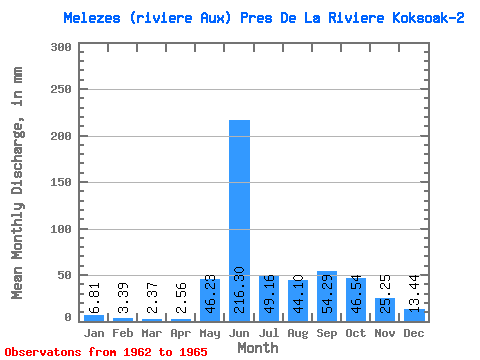
| Statistic | Jan | Feb | Mar | Apr | May | Jun | Jul | Aug | Sep | Oct | Nov | Dec | Annual |
|---|---|---|---|---|---|---|---|---|---|---|---|---|---|
| Mean | 6.80 | 3.42 | 2.37 | 2.56 | 46.22 | 216.30 | 49.15 | 44.09 | 54.29 | 46.54 | 25.25 | 13.44 | 516.88 |
| Standard Deviation | 1.56 | 0.82 | 0.39 | 0.66 | 8.85 | 32.26 | 11.16 | 27.23 | 20.14 | 15.72 | 6.12 | 0.47 | 29.52 |
| Min | 5.05 | 2.47 | 1.96 | 2.05 | 36.69 | 193.03 | 38.51 | 24.84 | 31.93 | 35.94 | 19.43 | 12.98 | 496.01 |
| Max | 8.03 | 3.91 | 2.72 | 3.30 | 54.19 | 253.13 | 60.77 | 63.34 | 71.02 | 64.60 | 31.63 | 13.92 | 537.75 |
| Coefficient of Variation | 0.23 | 0.24 | 0.16 | 0.26 | 0.19 | 0.15 | 0.23 | 0.62 | 0.37 | 0.34 | 0.24 | 0.04 | 0.06 |
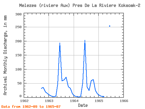
| Year | Jan | Feb | Mar | Apr | May | Jun | Jul | Aug | Sep | Oct | Nov | Dec | Annual | 1962 | 31.93 | 35.94 | 19.43 | 13.42 | 1963 | 8.03 | 3.87 | 2.43 | 3.30 | 47.79 | 193.03 | 60.77 | 63.34 | 71.02 | 39.07 | 31.63 | 12.98 | 537.75 | 1964 | 5.05 | 2.47 | 1.96 | 2.32 | 54.19 | 202.75 | 38.51 | 24.84 | 59.91 | 64.60 | 24.71 | 13.92 | 496.01 | 1965 | 7.34 | 3.91 | 2.72 | 2.05 | 36.69 | 253.13 | 48.17 |
|---|
| Other Close Sites | ||||||
|---|---|---|---|---|---|---|
| PointID | Latitude | Longitude | Drainage Area | Source | Name | |
| 5172 | "MELEZES (RIVIERE AUX) PRES DE LA RIVIERE KOKSOAK" | 57.67 | -1235999 | Hydat | ||
 Return to R-Arctic Net Home Page