|
|
|||||||||||||||||
| Point ID: 5125 | Downloads | Plots | Site Data | Other Close Sites | Code: 03DD005 |
|
|
|||||||||||||||||
| Download | |
|---|---|
| Site Descriptor Information | Site Time Series Data |
| Link to all available data | |
|
|
| View: | Statistics | Time Series |
| Units: | m3/s |
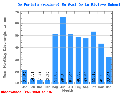
| Statistic | Jan | Feb | Mar | Apr | May | Jun | Jul | Aug | Sep | Oct | Nov | Dec | Annual |
|---|---|---|---|---|---|---|---|---|---|---|---|---|---|
| Mean | 21.57 | 14.63 | 13.40 | 13.37 | 51.01 | 65.34 | 50.99 | 48.59 | 47.50 | 53.16 | 43.22 | 32.08 | 453.43 |
| Standard Deviation | 3.28 | 2.08 | 1.78 | 3.11 | 13.06 | 10.92 | 8.93 | 11.28 | 8.52 | 10.57 | 6.27 | 4.12 | 39.39 |
| Min | 15.41 | 10.43 | 10.21 | 9.48 | 35.32 | 46.02 | 38.81 | 32.21 | 27.42 | 34.54 | 31.18 | 23.48 | 375.12 |
| Max | 26.00 | 18.57 | 17.78 | 19.53 | 75.88 | 84.33 | 68.70 | 68.89 | 61.42 | 71.41 | 56.16 | 37.84 | 528.00 |
| Coefficient of Variation | 0.15 | 0.14 | 0.13 | 0.23 | 0.26 | 0.17 | 0.17 | 0.23 | 0.18 | 0.20 | 0.14 | 0.13 | 0.09 |
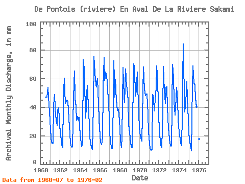
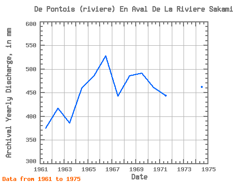
| Year | Jan | Feb | Mar | Apr | May | Jun | Jul | Aug | Sep | Oct | Nov | Dec | Annual | 1960 | 48.51 | 48.71 | 46.96 | 55.89 | 47.14 | 37.84 | 1961 | 25.23 | 17.11 | 15.06 | 15.01 | 43.27 | 48.84 | 40.17 | 32.21 | 27.42 | 39.01 | 39.63 | 32.99 | 375.12 | 1962 | 23.68 | 16.11 | 14.17 | 11.55 | 45.80 | 60.29 | 44.44 | 45.41 | 45.08 | 45.60 | 37.75 | 27.56 | 416.53 | 1963 | 16.15 | 12.34 | 12.28 | 12.41 | 48.51 | 65.36 | 47.54 | 41.92 | 31.18 | 34.54 | 31.18 | 33.77 | 386.00 | 1964 | 21.35 | 14.32 | 12.77 | 16.00 | 75.88 | 67.05 | 42.30 | 33.57 | 48.84 | 57.05 | 42.26 | 29.50 | 459.68 | 1965 | 19.11 | 13.40 | 12.30 | 10.50 | 41.72 | 75.51 | 65.98 | 57.83 | 54.47 | 61.90 | 42.45 | 32.41 | 486.09 | 1966 | 20.96 | 14.53 | 14.42 | 18.97 | 55.31 | 74.75 | 60.55 | 66.76 | 61.42 | 60.35 | 46.02 | 35.51 | 528.00 | 1967 | 21.73 | 14.30 | 12.42 | 10.84 | 41.33 | 72.69 | 48.51 | 61.13 | 45.08 | 39.01 | 39.63 | 36.87 | 442.45 | 1968 | 25.62 | 15.44 | 12.44 | 19.53 | 70.25 | 47.71 | 44.63 | 68.89 | 54.66 | 54.92 | 44.70 | 29.11 | 486.05 | 1969 | 22.90 | 14.32 | 12.59 | 11.68 | 35.32 | 70.44 | 68.70 | 49.29 | 51.46 | 66.76 | 52.78 | 36.68 | 491.52 | 1970 | 26.00 | 18.57 | 17.78 | 16.27 | 53.17 | 68.18 | 54.53 | 49.68 | 49.02 | 50.84 | 34.94 | 23.48 | 461.43 | 1971 | 15.41 | 10.43 | 10.21 | 10.57 | 50.45 | 46.02 | 38.81 | 46.57 | 53.72 | 71.41 | 56.16 | 35.90 | 444.11 | 1972 | 24.45 | 16.05 | 13.88 | 11.64 | 39.01 | 68.74 | 53.95 | 44.44 | 53.91 | 56.08 | 39.63 | 26.20 | 447.16 | 1973 | 18.71 | 13.97 | 13.31 | 13.13 | 72.38 | 61.04 | 45.41 | 35.71 | 46.39 | 55.89 | 44.70 | 32.02 | 451.27 | 1974 | 23.29 | 16.76 | 15.29 | 12.96 | 36.09 | 84.33 | 52.98 | 38.03 | 43.95 | 59.77 | 46.39 | 32.80 | 462.08 | 1975 | 22.32 | 14.73 | 12.13 | 9.48 | 56.66 | 69.12 | 58.80 | 57.25 | 46.39 | 41.53 | 46.20 | 30.66 | 463.93 | 1976 | 18.16 | 11.69 |
|---|
| Other Close Sites | ||||||
|---|---|---|---|---|---|---|
| PointID | Latitude | Longitude | Drainage Area | Source | Name | |
| 5121 | "MASTA (CHENAL) EN AVAL DE LA RIVIERE DE PONTOIS" | 53.25 | -1065352 | Hydat | ||
| 5122 | "DE PONTOIS (RIVIERE) EN AMONT DE LA RIVIERE SAKAMI" | 53.16 | -1078030 | Hydat | ||
| 5124 | "MASTA (CHENAL) EN AVAL DE LA RIVIERE DE PONTOIS-1" | 53.24 | -1064956 | Hydat | ||
| 5128 | "SAKAMI (RIVIERE) EN AVAL DE LA RIVIERE DE PONTOIS-1" | 53.25 | -1053856 | Hydat | ||
| 5129 | "SAKAMI (RIVIERE) EN AVAL DE LA RIVIERE DE PONTOIS-2" | 53.25 | -1053856 | Hydat | ||
| 5130 | "FREGATE (LAC DE LA)" | 53.16 | -1054313 | Hydat | ||
 Return to R-Arctic Net Home Page