|
|
|||||||||||||||||
| Point ID: 5121 | Downloads | Plots | Site Data | Other Close Sites | Code: 03DD001 |
|
|
|||||||||||||||||
| Download | |
|---|---|
| Site Descriptor Information | Site Time Series Data |
| Link to all available data | |
|
|
| View: | Statistics | Time Series |
| Units: | m3/s |
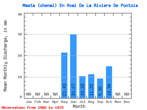
| Statistic | Jan | Feb | Mar | Apr | May | Jun | Jul | Aug | Sep | Oct | Nov | Dec | Annual |
|---|---|---|---|---|---|---|---|---|---|---|---|---|---|
| Mean | 21.42 | 30.07 | 10.32 | 11.21 | 9.30 | 14.94 | |||||||
| Standard Deviation | 8.95 | 13.58 | 7.48 | 9.00 | 4.60 | 8.37 | |||||||
| Min | 15.10 | 6.72 | 1.93 | 1.23 | 4.28 | 1.96 | |||||||
| Max | 27.75 | 52.97 | 26.00 | 26.20 | 18.41 | 29.50 | |||||||
| Coefficient of Variation | 0.42 | 0.45 | 0.72 | 0.80 | 0.49 | 0.56 |
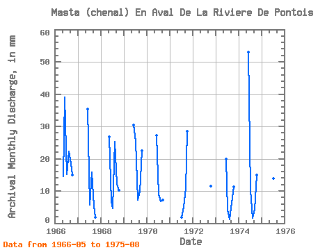
| Year | Jan | Feb | Mar | Apr | May | Jun | Jul | Aug | Sep | Oct | Nov | Dec | Annual | 1966 | 15.10 | 39.07 | 15.76 | 22.90 | 18.41 | 15.33 | 1967 | 35.31 | 5.92 | 16.34 | 5.30 | 1.96 | 1968 | 27.75 | 6.72 | 4.89 | 26.20 | 12.23 | 10.58 | 1969 | 30.43 | 26.00 | 7.41 | 9.80 | 23.29 | 1970 | 27.23 | 9.28 | 7.00 | 7.16 | 1971 | 1.93 | 5.24 | 10.82 | 29.50 | 1972 | 11.80 | 1973 | 19.91 | 4.37 | 1.23 | 6.41 | 11.57 | 1974 | 52.97 | 10.50 | 1.71 | 4.28 | 15.53 | 1975 | 28.93 | 14.28 | 12.88 |
|---|
| Other Close Sites | ||||||
|---|---|---|---|---|---|---|
| PointID | Latitude | Longitude | Drainage Area | Source | Name | |
| 5122 | "DE PONTOIS (RIVIERE) EN AMONT DE LA RIVIERE SAKAMI" | 53.16 | -1078030 | Hydat | ||
| 5124 | "MASTA (CHENAL) EN AVAL DE LA RIVIERE DE PONTOIS-1" | 53.24 | -1064956 | Hydat | ||
| 5125 | "DE PONTOIS (RIVIERE) EN AVAL DE LA RIVIERE SAKAMI" | 53.28 | -1056405 | Hydat | ||
| 5128 | "SAKAMI (RIVIERE) EN AVAL DE LA RIVIERE DE PONTOIS-1" | 53.25 | -1053856 | Hydat | ||
| 5129 | "SAKAMI (RIVIERE) EN AVAL DE LA RIVIERE DE PONTOIS-2" | 53.25 | -1053856 | Hydat | ||
| 5130 | "FREGATE (LAC DE LA)" | 53.16 | -1054313 | Hydat | ||
 Return to R-Arctic Net Home Page