|
|
|||||||||||||||||
| Point ID: 9415 | Downloads | Plots | Site Data | Code: 15512000 |
|
|
|||||||||||||||||
| Download | |
|---|---|
| Site Descriptor Information | Site Time Series Data |
| Link to all available data | |
|
|
| View: | Statistics | Time Series |
| Units: | mm |
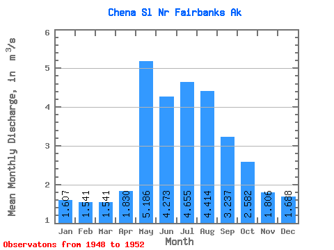
| Statistic | Jan | Feb | Mar | Apr | May | Jun | Jul | Aug | Sep | Oct | Nov | Dec | Annual |
|---|---|---|---|---|---|---|---|---|---|---|---|---|---|
| Mean | 1.61 | 1.54 | 1.54 | 1.83 | 5.19 | 4.27 | 4.66 | 4.41 | 3.24 | 2.58 | 1.81 | 1.69 | 2.70 |
| Standard Deviation | 0.06 | 0.05 | 0.05 | 0.28 | 3.27 | 1.87 | 1.54 | 1.66 | 1.00 | 0.79 | 0.13 | 0.12 | 0.62 |
| Min | 1.53 | 1.50 | 1.47 | 1.55 | 2.32 | 2.49 | 2.92 | 2.60 | 2.33 | 1.81 | 1.63 | 1.56 | 2.10 |
| Max | 1.67 | 1.59 | 1.59 | 2.11 | 10.36 | 6.72 | 6.47 | 6.26 | 4.74 | 3.68 | 1.93 | 1.85 | 3.34 |
| Coefficient of Variation | 0.04 | 0.03 | 0.03 | 0.15 | 0.63 | 0.44 | 0.33 | 0.38 | 0.31 | 0.31 | 0.07 | 0.07 | 0.23 |
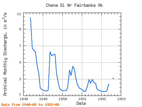
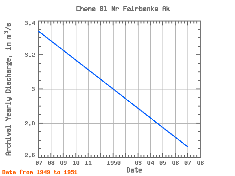
| Year | Jan | Feb | Mar | Apr | May | Jun | Jul | Aug | Sep | Oct | Nov | Dec | Annual | 1948 | 10.36 | 6.72 | 6.47 | 6.26 | 4.74 | 3.68 | 1.93 | 1.70 | 1949 | 1.64 | 1.59 | 1.56 | 1.63 | 6.29 | 5.79 | 5.93 | 5.96 | 3.72 | 2.52 | 1.80 | 1.64 | 3.34 | 1950 | 1.59 | 1.57 | 1.59 | 2.03 | 4.05 | 3.42 | 4.52 | 4.20 | 2.94 | 2.32 | 1.87 | 1.85 | 2.66 | 1951 | 1.67 | 1.50 | 1.55 | 2.11 | 2.90 | 2.49 | 2.92 | 2.60 | 2.46 | 1.81 | 1.63 | 1.56 | 2.10 | 1952 | 1.53 | 1.50 | 1.47 | 1.55 | 2.32 | 2.95 | 3.43 | 3.06 | 2.33 |
|---|
 Return to R-Arctic Net Home Page