|
|
|||||||||||||||||
| Point ID: 9415 | Downloads | Plots | Site Data | Code: 15512000 |
|
|
|||||||||||||||||
| Download | |
|---|---|
| Site Descriptor Information | Site Time Series Data |
| Link to all available data | |
|
|
| View: | Statistics | Time Series |
| Units: | m3/s |
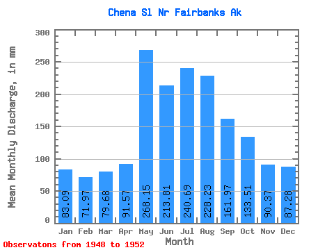
| Statistic | Jan | Feb | Mar | Apr | May | Jun | Jul | Aug | Sep | Oct | Nov | Dec | Annual |
|---|---|---|---|---|---|---|---|---|---|---|---|---|---|
| Mean | 83.08 | 72.57 | 79.64 | 91.55 | 268.09 | 213.81 | 240.68 | 228.22 | 161.96 | 133.48 | 90.38 | 87.27 | 1645.09 |
| Standard Deviation | 3.25 | 2.16 | 2.51 | 13.94 | 169.02 | 93.45 | 79.41 | 85.60 | 50.15 | 40.84 | 6.35 | 6.42 | 378.11 |
| Min | 79.05 | 70.70 | 76.10 | 77.59 | 119.86 | 124.51 | 151.01 | 134.26 | 116.56 | 93.50 | 81.70 | 80.50 | 1278.92 |
| Max | 86.39 | 74.71 | 81.99 | 105.47 | 535.76 | 336.10 | 334.60 | 323.53 | 237.29 | 190.17 | 96.35 | 95.77 | 2034.11 |
| Coefficient of Variation | 0.04 | 0.03 | 0.03 | 0.15 | 0.63 | 0.44 | 0.33 | 0.38 | 0.31 | 0.31 | 0.07 | 0.07 | 0.23 |
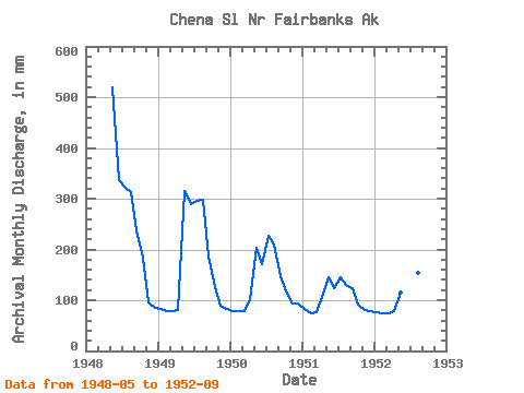
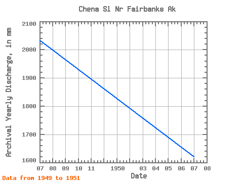
| Year | Jan | Feb | Mar | Apr | May | Jun | Jul | Aug | Sep | Oct | Nov | Dec | Annual | 1948 | 535.76 | 336.10 | 334.60 | 323.53 | 237.29 | 190.17 | 96.35 | 87.84 | 1949 | 84.89 | 74.71 | 80.50 | 81.70 | 325.37 | 289.86 | 306.42 | 307.99 | 185.96 | 130.15 | 89.93 | 84.99 | 2034.11 | 1950 | 81.99 | 74.16 | 81.99 | 101.44 | 209.39 | 171.02 | 233.89 | 217.18 | 147.12 | 120.09 | 93.52 | 95.77 | 1622.23 | 1951 | 86.39 | 70.70 | 79.98 | 105.47 | 150.08 | 124.51 | 151.01 | 134.26 | 122.85 | 93.50 | 81.70 | 80.50 | 1278.92 | 1952 | 79.05 | 70.70 | 76.10 | 77.59 | 119.86 | 147.54 | 177.48 | 158.15 | 116.56 |
|---|
 Return to R-Arctic Net Home Page