|
|
|||||||||||||||||
| Point ID: 9235 | Downloads | Plots | Site Data | Code: 15225945 |
|
|
|||||||||||||||||
| Download | |
|---|---|
| Site Descriptor Information | Site Time Series Data |
| Link to all available data | |
|
|
| View: | Statistics | Time Series |
| Units: | mm |
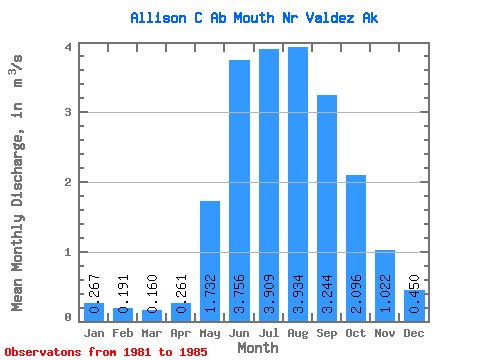
| Statistic | Jan | Feb | Mar | Apr | May | Jun | Jul | Aug | Sep | Oct | Nov | Dec | Annual |
|---|---|---|---|---|---|---|---|---|---|---|---|---|---|
| Mean | 0.27 | 0.19 | 0.16 | 0.26 | 1.73 | 3.76 | 3.91 | 3.93 | 3.24 | 2.10 | 1.02 | 0.45 | 1.64 |
| Standard Deviation | 0.10 | 0.07 | 0.07 | 0.17 | 0.65 | 0.35 | 0.39 | 1.41 | 1.06 | 0.40 | 0.45 | 0.17 | 0.08 |
| Min | 0.17 | 0.14 | 0.08 | 0.09 | 1.10 | 3.18 | 3.58 | 2.71 | 1.89 | 1.71 | 0.55 | 0.26 | 1.55 |
| Max | 0.41 | 0.29 | 0.28 | 0.45 | 2.65 | 4.02 | 4.40 | 6.36 | 4.29 | 2.66 | 1.62 | 0.63 | 1.71 |
| Coefficient of Variation | 0.39 | 0.35 | 0.47 | 0.65 | 0.37 | 0.09 | 0.10 | 0.36 | 0.33 | 0.19 | 0.44 | 0.37 | 0.05 |
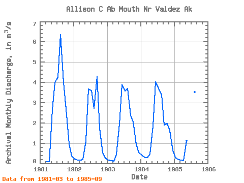
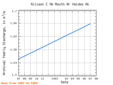
| Year | Jan | Feb | Mar | Apr | May | Jun | Jul | Aug | Sep | Oct | Nov | Dec | Annual | 1981 | 0.08 | 0.09 | 2.65 | 3.99 | 4.26 | 6.36 | 3.99 | 2.66 | 0.98 | 0.37 | 1982 | 0.20 | 0.16 | 0.16 | 0.18 | 1.11 | 3.68 | 3.61 | 2.71 | 4.29 | 1.71 | 0.55 | 0.26 | 1.55 | 1983 | 0.17 | 0.14 | 0.12 | 0.43 | 1.95 | 3.91 | 3.58 | 3.70 | 2.36 | 2.04 | 0.94 | 0.54 | 1.66 | 1984 | 0.41 | 0.29 | 0.28 | 0.45 | 1.85 | 4.02 | 3.69 | 3.37 | 1.89 | 1.97 | 1.62 | 0.63 | 1.71 | 1985 | 0.28 | 0.18 | 0.16 | 0.14 | 1.10 | 3.18 | 4.40 | 3.52 | 3.68 |
|---|
 Return to R-Arctic Net Home Page