|
|
|||||||||||||||||
| Point ID: 9235 | Downloads | Plots | Site Data | Code: 15225945 |
|
|
|||||||||||||||||
| Download | |
|---|---|
| Site Descriptor Information | Site Time Series Data |
| Link to all available data | |
|
|
| View: | Statistics | Time Series |
| Units: | m3/s |
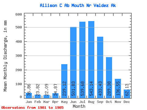
| Statistic | Jan | Feb | Mar | Apr | May | Jun | Jul | Aug | Sep | Oct | Nov | Dec | Annual |
|---|---|---|---|---|---|---|---|---|---|---|---|---|---|
| Mean | 36.80 | 24.04 | 22.16 | 34.87 | 239.07 | 501.80 | 539.58 | 543.05 | 433.42 | 289.35 | 136.61 | 62.14 | 2665.65 |
| Standard Deviation | 14.39 | 8.48 | 10.32 | 22.56 | 89.47 | 46.74 | 53.95 | 194.19 | 141.09 | 55.80 | 59.50 | 23.25 | 129.93 |
| Min | 23.90 | 17.38 | 11.60 | 12.43 | 152.41 | 424.75 | 494.19 | 374.13 | 252.60 | 236.29 | 73.02 | 35.55 | 2522.85 |
| Max | 56.22 | 36.32 | 38.99 | 60.68 | 365.17 | 537.49 | 607.38 | 877.86 | 573.31 | 367.80 | 216.79 | 87.00 | 2776.89 |
| Coefficient of Variation | 0.39 | 0.35 | 0.47 | 0.65 | 0.37 | 0.09 | 0.10 | 0.36 | 0.33 | 0.19 | 0.44 | 0.37 | 0.05 |
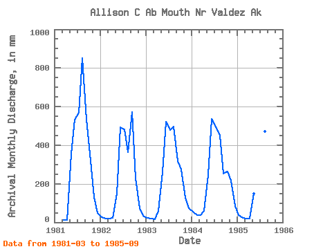
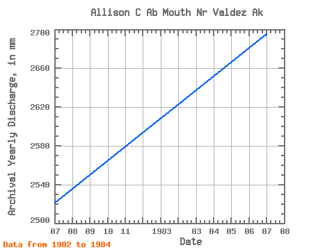
| Year | Jan | Feb | Mar | Apr | May | Jun | Jul | Aug | Sep | Oct | Nov | Dec | Annual | 1981 | 11.60 | 12.43 | 365.17 | 533.46 | 588.33 | 877.86 | 533.45 | 367.80 | 130.53 | 50.87 | 1982 | 28.25 | 19.68 | 21.64 | 24.45 | 152.95 | 491.20 | 497.92 | 374.13 | 573.31 | 236.29 | 73.02 | 35.55 | 2522.85 | 1983 | 23.90 | 17.38 | 16.57 | 57.52 | 269.71 | 522.11 | 494.19 | 511.18 | 315.53 | 281.56 | 126.12 | 75.15 | 2697.22 | 1984 | 56.22 | 36.32 | 38.99 | 60.68 | 255.09 | 537.49 | 510.06 | 465.65 | 252.60 | 271.73 | 216.79 | 87.00 | 2776.89 | 1985 | 38.84 | 22.77 | 21.97 | 19.25 | 152.41 | 424.75 | 607.38 | 486.46 | 492.22 |
|---|
 Return to R-Arctic Net Home Page