|
|
|||||||||||||||||
| Point ID: 8574 | Downloads | Plots | Site Data | Code: 11140 |
|
|
|||||||||||||||||
| Download | |
|---|---|
| Site Descriptor Information | Site Time Series Data |
| Link to all available data | |
| View: | Time Series | All |
| Units: | mm |
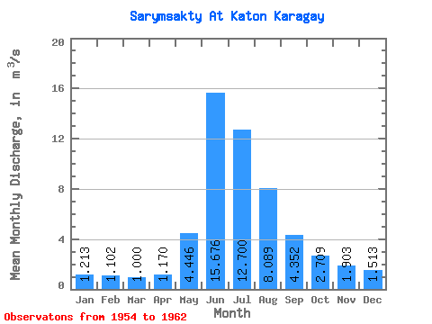
| Statistic | Jan | Feb | Mar | Apr | May | Jun | Jul | Aug | Sep | Oct | Nov | Dec | Annual |
|---|---|---|---|---|---|---|---|---|---|---|---|---|---|
| Mean | 1.21 | 1.10 | 1.00 | 1.17 | 4.45 | 15.68 | 12.70 | 8.09 | 4.35 | 2.71 | 1.90 | 1.51 | 4.55 |
| Standard Deviation | 0.28 | 0.30 | 0.24 | 0.36 | 2.29 | 4.11 | 5.88 | 3.46 | 1.24 | 0.60 | 0.33 | 0.31 | 0.98 |
| Min | 0.96 | 0.85 | 0.78 | 0.77 | 0.98 | 8.51 | 3.95 | 2.91 | 2.59 | 1.77 | 1.29 | 1.12 | 3.09 |
| Max | 1.78 | 1.59 | 1.39 | 1.64 | 7.87 | 19.60 | 19.90 | 13.00 | 6.08 | 3.39 | 2.26 | 2.13 | 5.65 |
| Coefficient of Variation | 0.23 | 0.27 | 0.24 | 0.31 | 0.52 | 0.26 | 0.46 | 0.43 | 0.28 | 0.22 | 0.18 | 0.21 | 0.22 |
 Return to R-Arctic Net Home Page