|
|
|||||||||||||||||
| Point ID: 8574 | Downloads | Plots | Site Data | Code: 11140 |
|
|
|||||||||||||||||
| Download | |
|---|---|
| Site Descriptor Information | Site Time Series Data |
| Link to all available data | |
| View: | Time Series | All |
| Units: | m3/s |
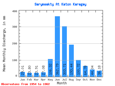
| Statistic | Jan | Feb | Mar | Apr | May | Jun | Jul | Aug | Sep | Oct | Nov | Dec | Annual |
|---|---|---|---|---|---|---|---|---|---|---|---|---|---|
| Mean | 29.01 | 24.01 | 23.91 | 27.08 | 106.30 | 362.79 | 303.67 | 193.41 | 100.72 | 64.77 | 44.05 | 36.19 | 1282.57 |
| Standard Deviation | 6.69 | 6.54 | 5.71 | 8.28 | 54.84 | 95.02 | 140.53 | 82.78 | 28.69 | 14.42 | 7.73 | 7.45 | 276.79 |
| Min | 22.95 | 18.52 | 18.65 | 17.82 | 23.43 | 196.95 | 94.45 | 69.58 | 59.94 | 42.32 | 29.85 | 26.78 | 871.89 |
| Max | 42.56 | 34.64 | 33.24 | 37.95 | 188.18 | 453.60 | 475.82 | 310.84 | 140.71 | 81.06 | 52.30 | 50.93 | 1592.79 |
| Coefficient of Variation | 0.23 | 0.27 | 0.24 | 0.31 | 0.52 | 0.26 | 0.46 | 0.43 | 0.28 | 0.22 | 0.18 | 0.21 | 0.22 |
 Return to R-Arctic Net Home Page