|
|
|||||||||||||||||
| Point ID: 8001 | Downloads | Plots | Site Data | Code: 3665 |
|
|
|||||||||||||||||
| Download | |
|---|---|
| Site Descriptor Information | Site Time Series Data |
| Link to all available data | |
|
|
| View: | Statistics | Time Series |
| Units: | mm |
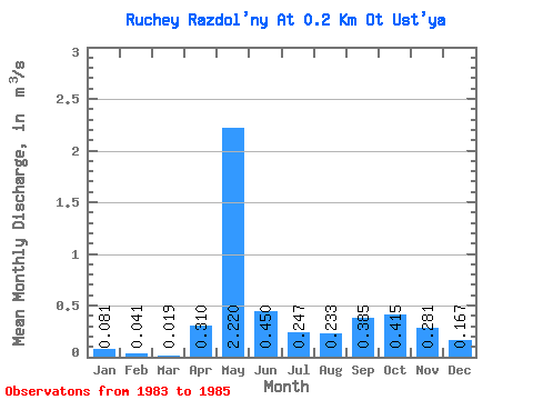
| Statistic | Jan | Feb | Mar | Apr | May | Jun | Jul | Aug | Sep | Oct | Nov | Dec | Annual |
|---|---|---|---|---|---|---|---|---|---|---|---|---|---|
| Mean | 0.08 | 0.04 | 0.02 | 0.31 | 2.22 | 0.45 | 0.25 | 0.23 | 0.39 | 0.41 | 0.28 | 0.17 | 0.40 |
| Standard Deviation | 0.11 | 0.06 | 0.03 | 0.11 | 0.37 | 0.17 | 0.24 | 0.18 | 0.19 | 0.36 | 0.28 | 0.17 | |
| Min | 0.00 | 0.00 | 0.00 | 0.23 | 1.96 | 0.33 | 0.07 | 0.03 | 0.25 | 0.16 | 0.08 | 0.04 | 0.40 |
| Max | 0.16 | 0.08 | 0.04 | 0.39 | 2.48 | 0.57 | 0.42 | 0.35 | 0.52 | 0.67 | 0.48 | 0.29 | 0.40 |
| Coefficient of Variation | 1.36 | 1.41 | 1.41 | 0.36 | 0.17 | 0.38 | 0.99 | 0.76 | 0.50 | 0.87 | 1.00 | 1.03 |
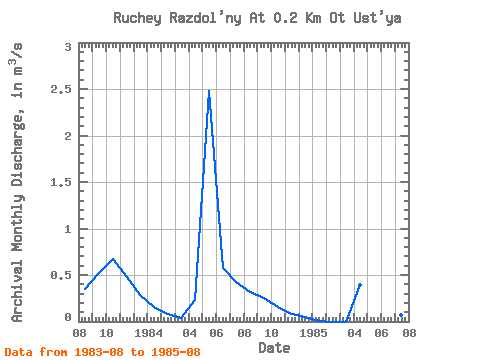
| Year | Jan | Feb | Mar | Apr | May | Jun | Jul | Aug | Sep | Oct | Nov | Dec | Annual | 1983 | 0.35 | 0.52 | 0.67 | 0.48 | 0.29 | 1984 | 0.16 | 0.08 | 0.04 | 0.23 | 2.48 | 0.57 | 0.42 | 0.32 | 0.25 | 0.16 | 0.08 | 0.04 | 0.40 | 1985 | 0.00 | 0.00 | 0.00 | 0.39 | 1.96 | 0.33 | 0.07 | 0.03 |
|---|
 Return to R-Arctic Net Home Page