|
|
|||||||||||||||||
| Point ID: 8001 | Downloads | Plots | Site Data | Code: 3665 |
|
|
|||||||||||||||||
| Download | |
|---|---|
| Site Descriptor Information | Site Time Series Data |
| Link to all available data | |
|
|
| View: | Statistics | Time Series |
| Units: | m3/s |
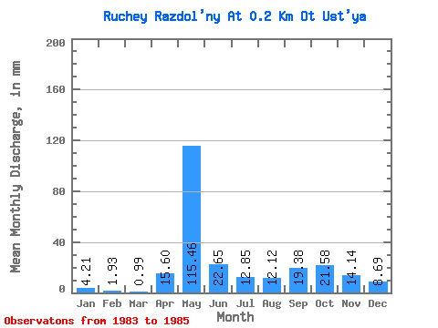
| Statistic | Jan | Feb | Mar | Apr | May | Jun | Jul | Aug | Sep | Oct | Nov | Dec | Annual |
|---|---|---|---|---|---|---|---|---|---|---|---|---|---|
| Mean | 4.24 | 1.94 | 0.96 | 15.60 | 115.44 | 22.65 | 12.84 | 12.12 | 19.38 | 21.58 | 14.14 | 8.71 | 246.97 |
| Standard Deviation | 5.77 | 2.75 | 1.36 | 5.69 | 19.12 | 8.54 | 12.72 | 9.22 | 9.61 | 18.75 | 14.16 | 9.01 | |
| Min | 0.16 | 0.00 | 0.00 | 11.58 | 101.92 | 16.61 | 3.85 | 1.51 | 12.58 | 8.32 | 4.13 | 2.34 | 246.97 |
| Max | 8.32 | 3.88 | 1.92 | 19.63 | 128.96 | 28.69 | 21.84 | 18.20 | 26.17 | 34.84 | 24.16 | 15.08 | 246.97 |
| Coefficient of Variation | 1.36 | 1.41 | 1.41 | 0.36 | 0.17 | 0.38 | 0.99 | 0.76 | 0.50 | 0.87 | 1.00 | 1.03 |
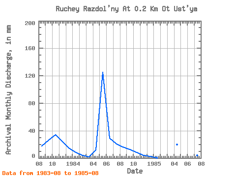
| Year | Jan | Feb | Mar | Apr | May | Jun | Jul | Aug | Sep | Oct | Nov | Dec | Annual | 1983 | 18.20 | 26.17 | 34.84 | 24.16 | 15.08 | 1984 | 8.32 | 3.88 | 1.92 | 11.58 | 128.96 | 28.69 | 21.84 | 16.64 | 12.58 | 8.32 | 4.13 | 2.34 | 246.97 | 1985 | 0.16 | 0.00 | 0.00 | 19.63 | 101.92 | 16.61 | 3.85 | 1.51 |
|---|
 Return to R-Arctic Net Home Page