|
|
|||||||||||||||||
| Point ID: 7912 | Downloads | Plots | Site Data | Code: 3435 |
|
|
|||||||||||||||||
| Download | |
|---|---|
| Site Descriptor Information | Site Time Series Data |
| Link to all available data | |
|
|
| View: | Statistics | Time Series |
| Units: | mm |
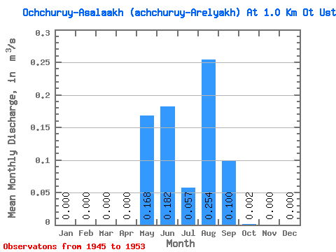
| Statistic | Jan | Feb | Mar | Apr | May | Jun | Jul | Aug | Sep | Oct | Nov | Dec | Annual |
|---|---|---|---|---|---|---|---|---|---|---|---|---|---|
| Mean | 0.00 | 0.00 | 0.00 | 0.00 | 0.17 | 0.18 | 0.06 | 0.25 | 0.10 | 0.00 | 0.00 | 0.00 | 0.06 |
| Standard Deviation | 0.00 | 0.00 | 0.00 | 0.00 | 0.19 | 0.19 | 0.05 | 0.44 | 0.10 | 0.00 | 0.00 | 0.00 | 0.06 |
| Min | 0.00 | 0.00 | 0.00 | 0.00 | 0.03 | 0.04 | 0.01 | 0.00 | 0.01 | 0.00 | 0.00 | 0.00 | 0.01 |
| Max | 0.00 | 0.00 | 0.00 | 0.00 | 0.52 | 0.53 | 0.15 | 1.13 | 0.22 | 0.01 | 0.00 | 0.00 | 0.16 |
| Coefficient of Variation | 1.11 | 1.04 | 0.95 | 1.72 | 0.98 | 2.00 | 0.93 |
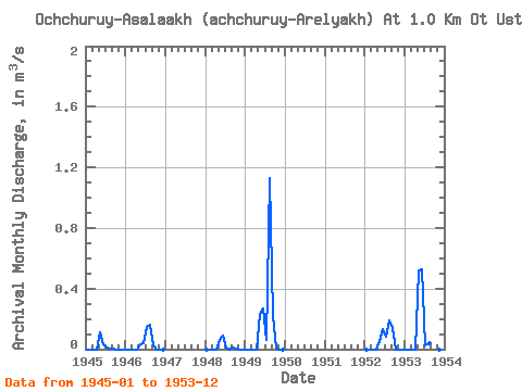
| Year | Jan | Feb | Mar | Apr | May | Jun | Jul | Aug | Sep | Oct | Nov | Dec | Annual | 1945 | 0.00 | 0.00 | 0.00 | 0.00 | 0.11 | 0.04 | 0.01 | 0.00 | 0.01 | 0.00 | 0.00 | 0.00 | 0.01 | 1946 | 0.00 | 0.00 | 0.00 | 0.00 | 0.03 | 0.04 | 0.15 | 0.16 | 0.02 | 0.00 | 0.00 | 0.00 | 0.03 | 1948 | 0.00 | 0.00 | 0.00 | 0.00 | 0.06 | 0.09 | 0.01 | 0.00 | 0.01 | 0.00 | 0.00 | 0.00 | 0.01 | 1949 | 0.00 | 0.00 | 0.00 | 0.00 | 0.23 | 0.27 | 0.06 | 1.13 | 0.22 | 0.01 | 0.00 | 0.00 | 0.16 | 1952 | 0.00 | 0.00 | 0.00 | 0.00 | 0.06 | 0.13 | 0.09 | 0.19 | 0.14 | 0.00 | 0.00 | 0.00 | 0.05 | 1953 | 0.00 | 0.00 | 0.00 | 0.00 | 0.52 | 0.53 | 0.03 | 0.04 | 0.20 | 0.00 | 0.00 | 0.00 | 0.11 |
|---|
 Return to R-Arctic Net Home Page