|
|
|||||||||||||||||
| Point ID: 7281 | Downloads | Plots | Site Data | Code: 49038 |
|
|
|||||||||||||||||
| Download | |
|---|---|
| Site Descriptor Information | Site Time Series Data |
| Link to all available data | |
|
|
| View: | Statistics | Time Series |
| Units: | mm |
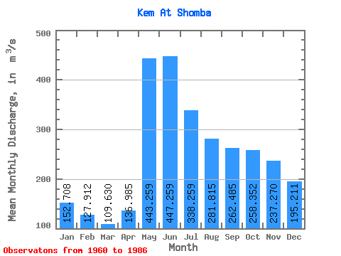
| Statistic | Jan | Feb | Mar | Apr | May | Jun | Jul | Aug | Sep | Oct | Nov | Dec | Annual |
|---|---|---|---|---|---|---|---|---|---|---|---|---|---|
| Mean | 152.71 | 127.91 | 109.63 | 136.99 | 443.26 | 447.26 | 338.26 | 281.81 | 262.49 | 258.35 | 237.27 | 195.21 | 254.44 |
| Standard Deviation | 49.59 | 40.80 | 35.51 | 67.30 | 141.06 | 137.91 | 111.49 | 100.16 | 104.73 | 96.14 | 89.08 | 70.13 | 48.44 |
| Min | 43.50 | 45.40 | 37.60 | 48.80 | 157.00 | 171.00 | 199.00 | 138.00 | 95.10 | 77.50 | 56.90 | 39.90 | 177.85 |
| Max | 247.00 | 218.00 | 193.00 | 330.00 | 737.00 | 740.00 | 644.00 | 539.00 | 567.00 | 492.00 | 387.00 | 311.00 | 369.17 |
| Coefficient of Variation | 0.33 | 0.32 | 0.32 | 0.49 | 0.32 | 0.31 | 0.33 | 0.35 | 0.40 | 0.37 | 0.38 | 0.36 | 0.19 |
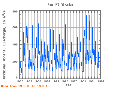
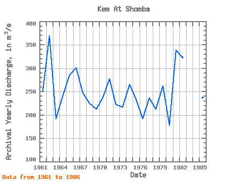
| Year | Jan | Feb | Mar | Apr | May | Jun | Jul | Aug | Sep | Oct | Nov | Dec | Annual | 1960 | 37.60 | 103.00 | 157.00 | 171.00 | 205.00 | 151.00 | 95.10 | 77.50 | 56.90 | 39.90 | 1961 | 43.50 | 45.40 | 48.20 | 48.80 | 375.00 | 543.00 | 422.00 | 381.00 | 413.00 | 302.00 | 240.00 | 162.00 | 251.99 | 1962 | 142.00 | 166.00 | 153.00 | 330.00 | 612.00 | 508.00 | 644.00 | 539.00 | 472.00 | 360.00 | 312.00 | 192.00 | 369.17 | 1963 | 156.00 | 120.00 | 109.00 | 120.00 | 329.00 | 278.00 | 219.00 | 138.00 | 155.00 | 219.00 | 246.00 | 215.00 | 192.00 | 1964 | 165.00 | 121.00 | 93.70 | 98.20 | 621.00 | 606.00 | 342.00 | 203.00 | 155.00 | 173.00 | 170.00 | 166.00 | 242.82 | 1965 | 120.00 | 87.60 | 109.00 | 134.00 | 342.00 | 351.00 | 360.00 | 380.00 | 366.00 | 481.00 | 387.00 | 311.00 | 285.72 | 1966 | 226.00 | 149.00 | 107.00 | 96.00 | 489.00 | 643.00 | 429.00 | 350.00 | 278.00 | 326.00 | 302.00 | 214.00 | 300.75 | 1967 | 134.00 | 121.00 | 107.00 | 184.00 | 413.00 | 463.00 | 334.00 | 240.00 | 223.00 | 201.00 | 335.00 | 217.00 | 247.67 | 1968 | 158.00 | 106.00 | 90.80 | 83.20 | 432.00 | 421.00 | 373.00 | 306.00 | 237.00 | 218.00 | 166.00 | 117.00 | 225.67 | 1969 | 119.00 | 102.00 | 95.20 | 94.40 | 385.00 | 347.00 | 251.00 | 194.00 | 202.00 | 326.00 | 244.00 | 188.00 | 212.30 | 1970 | 147.00 | 117.00 | 95.90 | 80.20 | 551.00 | 583.00 | 332.00 | 253.00 | 189.00 | 196.00 | 149.00 | 149.00 | 236.84 | 1971 | 121.00 | 95.50 | 106.00 | 136.00 | 564.00 | 569.00 | 356.00 | 280.00 | 226.00 | 274.00 | 322.00 | 278.00 | 277.29 | 1972 | 190.00 | 140.00 | 105.00 | 114.00 | 364.00 | 423.00 | 282.00 | 257.00 | 204.00 | 194.00 | 166.00 | 220.00 | 221.58 | 1973 | 176.00 | 152.00 | 111.00 | 133.00 | 513.00 | 524.00 | 300.00 | 182.00 | 160.00 | 135.00 | 102.00 | 111.00 | 216.58 | 1974 | 95.50 | 88.00 | 83.90 | 80.20 | 333.00 | 467.00 | 463.00 | 440.00 | 378.00 | 312.00 | 227.00 | 208.00 | 264.63 | 1975 | 199.00 | 177.00 | 150.00 | 154.00 | 632.00 | 426.00 | 248.00 | 179.00 | 147.00 | 183.00 | 177.00 | 118.00 | 232.50 | 1976 | 101.00 | 90.60 | 78.20 | 115.00 | 236.00 | 323.00 | 339.00 | 283.00 | 249.00 | 214.00 | 146.00 | 126.00 | 191.73 | 1977 | 120.00 | 103.00 | 96.20 | 110.00 | 430.00 | 409.00 | 265.00 | 292.00 | 257.00 | 262.00 | 296.00 | 189.00 | 235.77 | 1978 | 164.00 | 118.00 | 96.00 | 92.30 | 241.00 | 290.00 | 225.00 | 217.00 | 292.00 | 319.00 | 274.00 | 221.00 | 212.44 | 1979 | 147.00 | 116.00 | 105.00 | 88.80 | 483.00 | 478.00 | 358.00 | 300.00 | 254.00 | 276.00 | 312.00 | 219.00 | 261.40 | 1980 | 140.00 | 109.00 | 108.00 | 185.00 | 431.00 | 316.00 | 199.00 | 182.00 | 196.00 | 105.00 | 84.40 | 78.80 | 177.85 | 1981 | 82.40 | 86.60 | 72.30 | 81.50 | 340.00 | 610.00 | 624.00 | 507.00 | 567.00 | 492.00 | 329.00 | 260.00 | 337.65 | 1982 | 247.00 | 195.00 | 151.00 | 200.00 | 737.00 | 626.00 | 371.00 | 291.00 | 328.00 | 229.00 | 202.00 | 306.00 | 323.58 | 1983 | 245.00 | 178.00 | 158.00 | 287.00 | 612.00 | 740.00 | 411.00 | 265.00 | 249.00 | 264.00 | 268.00 | 221.00 | 324.83 | 1984 | 170.00 | 218.00 | 193.00 | 263.00 | 605.00 | 327.00 | 271.00 | 312.00 | 277.00 | 330.00 | 382.00 | 288.00 | 303.00 | 1985 | 229.00 | 196.00 | 178.00 | 160.00 | 433.00 | 317.00 | 249.00 | 243.00 | 246.00 | 235.00 | 201.00 | 155.00 | 236.83 | 1986 | 133.00 | 128.00 | 122.00 | 127.00 | 308.00 | 317.00 | 261.00 | 244.00 | 272.00 | 272.00 | 310.00 | 301.00 | 232.92 |
|---|
 Return to R-Arctic Net Home Page