|
|
|||||||||||||||||
| Point ID: 7281 | Downloads | Plots | Site Data | Code: 49038 |
|
|
|||||||||||||||||
| Download | |
|---|---|
| Site Descriptor Information | Site Time Series Data |
| Link to all available data | |
| View: | Time Series | All |
| Units: | mm |
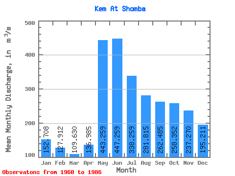
| Statistic | Jan | Feb | Mar | Apr | May | Jun | Jul | Aug | Sep | Oct | Nov | Dec | Annual |
|---|---|---|---|---|---|---|---|---|---|---|---|---|---|
| Mean | 152.71 | 127.91 | 109.63 | 136.99 | 443.26 | 447.26 | 338.26 | 281.81 | 262.49 | 258.35 | 237.27 | 195.21 | 254.44 |
| Standard Deviation | 49.59 | 40.80 | 35.51 | 67.30 | 141.06 | 137.91 | 111.49 | 100.16 | 104.73 | 96.14 | 89.08 | 70.13 | 48.44 |
| Min | 43.50 | 45.40 | 37.60 | 48.80 | 157.00 | 171.00 | 199.00 | 138.00 | 95.10 | 77.50 | 56.90 | 39.90 | 177.85 |
| Max | 247.00 | 218.00 | 193.00 | 330.00 | 737.00 | 740.00 | 644.00 | 539.00 | 567.00 | 492.00 | 387.00 | 311.00 | 369.17 |
| Coefficient of Variation | 0.33 | 0.32 | 0.32 | 0.49 | 0.32 | 0.31 | 0.33 | 0.35 | 0.40 | 0.37 | 0.38 | 0.36 | 0.19 |
 Return to R-Arctic Net Home Page