|
|
|||||||||||||||||
| Point ID: 6515 | Downloads | Plots | Site Data | Code: 8339 |
|
|
|||||||||||||||||
| Download | |
|---|---|
| Site Descriptor Information | Site Time Series Data |
| Link to all available data | |
|
|
| View: | Statistics | Time Series |
| Units: | mm |
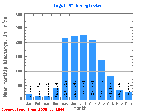
| Statistic | Jan | Feb | Mar | Apr | May | Jun | Jul | Aug | Sep | Oct | Nov | Dec | Annual |
|---|---|---|---|---|---|---|---|---|---|---|---|---|---|
| Mean | 20.64 | 15.75 | 15.89 | 42.51 | 214.52 | 221.55 | 223.37 | 209.57 | 136.72 | 84.45 | 36.16 | 28.55 | 104.03 |
| Standard Deviation | 4.34 | 4.35 | 5.76 | 28.18 | 70.02 | 86.44 | 80.59 | 81.43 | 35.24 | 24.34 | 9.15 | 6.22 | 18.25 |
| Min | 12.20 | 8.49 | 6.97 | 16.20 | 34.30 | 98.10 | 95.00 | 85.00 | 72.80 | 55.20 | 19.70 | 16.30 | 67.08 |
| Max | 29.90 | 27.20 | 34.80 | 159.00 | 348.00 | 501.00 | 452.00 | 505.00 | 208.00 | 152.00 | 54.50 | 48.70 | 134.17 |
| Coefficient of Variation | 0.21 | 0.28 | 0.36 | 0.66 | 0.33 | 0.39 | 0.36 | 0.39 | 0.26 | 0.29 | 0.25 | 0.22 | 0.17 |
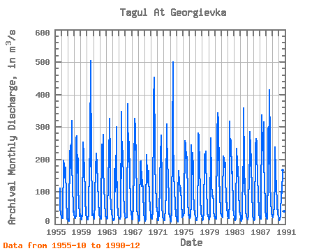
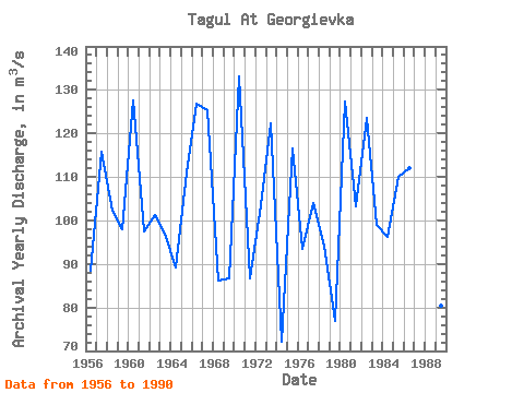
| Year | Jan | Feb | Mar | Apr | May | Jun | Jul | Aug | Sep | Oct | Nov | Dec | Annual | 1955 | 111.00 | 48.40 | 34.40 | 1956 | 21.40 | 18.90 | 19.10 | 23.80 | 197.00 | 179.00 | 171.00 | 142.00 | 176.00 | 76.10 | 19.70 | 16.30 | 88.36 | 1957 | 14.10 | 9.53 | 9.09 | 32.70 | 214.00 | 241.00 | 174.00 | 319.00 | 171.00 | 127.00 | 37.20 | 40.70 | 115.78 | 1958 | 29.00 | 21.30 | 19.20 | 27.60 | 265.00 | 273.00 | 157.00 | 204.00 | 109.00 | 66.80 | 23.80 | 31.70 | 102.28 | 1959 | 21.90 | 15.90 | 14.10 | 33.40 | 252.00 | 218.00 | 234.00 | 147.00 | 112.00 | 77.80 | 26.80 | 22.80 | 97.97 | 1960 | 15.70 | 13.40 | 14.00 | 31.70 | 202.00 | 177.00 | 245.00 | 505.00 | 180.00 | 87.10 | 27.50 | 31.80 | 127.52 | 1961 | 20.80 | 16.20 | 16.80 | 67.20 | 191.00 | 196.00 | 218.00 | 182.00 | 133.00 | 67.60 | 32.70 | 27.60 | 97.41 | 1962 | 22.50 | 17.60 | 15.60 | 35.50 | 246.00 | 197.00 | 277.00 | 166.00 | 118.00 | 68.60 | 26.50 | 23.70 | 101.17 | 1963 | 21.00 | 17.00 | 17.60 | 24.10 | 152.00 | 195.00 | 325.00 | 201.00 | 93.60 | 60.90 | 29.70 | 27.10 | 97.00 | 1964 | 23.20 | 12.60 | 10.90 | 16.20 | 172.00 | 100.00 | 123.00 | 300.00 | 194.00 | 65.30 | 31.30 | 21.30 | 89.15 | 1965 | 18.00 | 16.50 | 15.90 | 24.60 | 348.00 | 140.00 | 254.00 | 200.00 | 152.00 | 95.10 | 43.10 | 25.10 | 111.03 | 1966 | 18.50 | 21.10 | 21.30 | 20.60 | 326.00 | 371.00 | 192.00 | 255.00 | 149.00 | 67.90 | 41.80 | 38.80 | 126.92 | 1967 | 16.60 | 16.00 | 15.00 | 61.20 | 173.00 | 325.00 | 228.00 | 311.00 | 177.00 | 105.00 | 43.60 | 32.70 | 125.34 | 1968 | 22.00 | 10.70 | 11.20 | 51.20 | 193.00 | 194.00 | 133.00 | 118.00 | 136.00 | 98.60 | 34.70 | 32.10 | 86.21 | 1969 | 19.40 | 8.79 | 13.80 | 30.40 | 213.00 | 151.00 | 128.00 | 164.00 | 148.00 | 84.20 | 51.70 | 28.10 | 86.70 | 1970 | 20.20 | 18.40 | 16.20 | 43.00 | 34.30 | 380.00 | 452.00 | 227.00 | 170.00 | 132.00 | 54.50 | 48.70 | 133.03 | 1971 | 28.10 | 12.30 | 12.70 | 34.50 | 123.00 | 141.00 | 206.00 | 274.00 | 108.00 | 61.90 | 20.00 | 18.60 | 86.67 | 1972 | 13.10 | 11.20 | 11.50 | 51.10 | 93.80 | 309.00 | 268.00 | 200.00 | 139.00 | 82.70 | 31.60 | 30.40 | 103.45 | 1973 | 12.20 | 8.49 | 13.00 | 35.20 | 254.00 | 501.00 | 268.00 | 156.00 | 106.00 | 59.70 | 30.60 | 24.60 | 122.40 | 1974 | 20.30 | 14.40 | 6.97 | 94.10 | 165.00 | 129.00 | 111.00 | 103.00 | 113.00 | 62.30 | 26.40 | 20.30 | 72.15 | 1975 | 27.90 | 27.20 | 34.80 | 54.80 | 258.00 | 245.00 | 203.00 | 205.00 | 208.00 | 77.10 | 27.30 | 29.80 | 116.49 | 1976 | 20.90 | 18.20 | 24.00 | 65.10 | 244.00 | 154.00 | 221.00 | 169.00 | 95.70 | 55.20 | 31.50 | 23.80 | 93.53 | 1977 | 16.90 | 11.60 | 10.80 | 29.90 | 208.00 | 281.00 | 273.00 | 173.00 | 105.00 | 82.10 | 32.90 | 24.10 | 104.03 | 1978 | 19.60 | 12.80 | 13.00 | 34.80 | 207.00 | 217.00 | 187.00 | 225.00 | 89.40 | 62.40 | 33.30 | 27.90 | 94.10 | 1979 | 17.80 | 14.50 | 17.50 | 22.70 | 266.00 | 145.00 | 129.00 | 85.00 | 86.40 | 72.50 | 36.00 | 29.30 | 76.81 | 1980 | 18.40 | 18.70 | 15.40 | 22.00 | 275.00 | 342.00 | 196.00 | 331.00 | 144.00 | 88.10 | 43.10 | 34.40 | 127.34 | 1981 | 29.90 | 24.90 | 20.80 | 86.60 | 209.00 | 201.00 | 175.00 | 190.00 | 137.00 | 86.40 | 45.50 | 33.50 | 103.30 | 1982 | 26.00 | 19.30 | 18.90 | 70.50 | 318.00 | 209.00 | 260.00 | 155.00 | 174.00 | 152.00 | 52.10 | 27.40 | 123.52 | 1983 | 24.00 | 14.50 | 12.70 | 18.70 | 234.00 | 227.00 | 193.00 | 163.00 | 127.00 | 100.00 | 43.80 | 28.60 | 98.86 | 1984 | 26.10 | 12.40 | 8.93 | 19.00 | 178.00 | 126.00 | 358.00 | 184.00 | 98.20 | 80.80 | 38.60 | 25.10 | 96.26 | 1985 | 17.40 | 16.30 | 13.10 | 29.70 | 183.00 | 179.00 | 286.00 | 234.00 | 201.00 | 86.00 | 47.40 | 25.90 | 109.90 | 1986 | 17.00 | 12.20 | 14.40 | 21.50 | 239.00 | 263.00 | 250.00 | 214.00 | 149.00 | 84.70 | 47.30 | 31.90 | 112.00 | 1987 | 20.90 | 17.70 | 15.20 | 29.70 | 337.00 | 227.00 | 251.00 | 314.00 | 166.00 | 149.00 | 40.10 | 27.80 | 132.95 | 1988 | 23.50 | 17.50 | 15.20 | 159.00 | 296.00 | 185.00 | 415.00 | 246.00 | 120.00 | 74.60 | 31.40 | 26.80 | 134.17 | 1989 | 20.00 | 21.10 | 32.80 | 55.90 | 141.00 | 238.00 | 162.00 | 106.00 | 72.80 | 58.20 | 30.60 | 25.30 | 80.31 | 1990 | 18.00 | 11.90 | 14.70 | 30.00 | 101.00 | 98.10 | 95.00 | 167.00 | 127.00 | 73.60 | 39.10 | 29.50 | 67.08 |
|---|
 Return to R-Arctic Net Home Page