|
|
|||||||||||||||||
| Point ID: 609 | Downloads | Plots | Site Data | Code: 07AE001 |
|
|
|||||||||||||||||
| Download | |
|---|---|
| Site Descriptor Information | Site Time Series Data |
| Link to all available data | |
|
|
| View: | Statistics | Time Series |
| Units: | mm |
| Statistic | Jan | Feb | Mar | Apr | May | Jun | Jul | Aug | Sep | Oct | Nov | Dec | Annual |
|---|---|---|---|---|---|---|---|---|---|---|---|---|---|
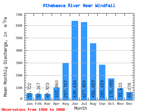
| Mean | 53.72 | 50.17 | 49.92 | 102.86 | 297.71 | 638.63 | 627.85 | 456.66 | 285.66 | 175.09 | 93.63 | 65.08 | 252.02 |
| Standard Deviation | 14.77 | 7.54 | 10.15 | 32.70 | 79.68 | 143.31 | 152.05 | 105.02 | 71.96 | 49.03 | 25.66 | 20.56 | 40.76 |
| Min | 36.40 | 35.70 | 28.10 | 45.50 | 184.00 | 419.00 | 378.00 | 309.00 | 155.00 | 95.80 | 56.20 | 40.90 | 184.79 |
| Max | 102.00 | 65.30 | 88.30 | 171.00 | 534.00 | 1030.00 | 1090.00 | 690.00 | 484.00 | 301.00 | 151.00 | 136.00 | 355.57 |
| Coefficient of Variation | 0.28 | 0.15 | 0.20 | 0.32 | 0.27 | 0.22 | 0.24 | 0.23 | 0.25 | 0.28 | 0.27 | 0.32 | 0.16 |
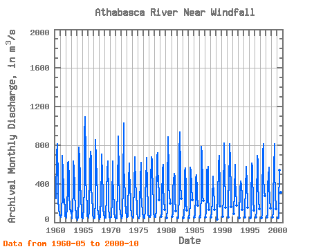
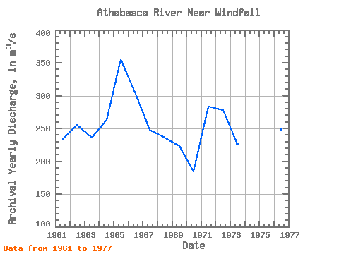
| Year | Jan | Feb | Mar | Apr | May | Jun | Jul | Aug | Sep | Oct | Nov | Dec | Annual | 1960 | 249.00 | 707.00 | 813.00 | 409.00 | 228.00 | 145.00 | 72.30 | 81.00 | 1961 | 65.70 | 57.80 | 55.10 | 84.30 | 317.00 | 692.00 | 502.00 | 399.00 | 207.00 | 237.00 | 128.00 | 60.10 | 233.75 | 1962 | 68.20 | 53.50 | 43.20 | 158.00 | 360.00 | 614.00 | 629.00 | 449.00 | 294.00 | 150.00 | 111.00 | 136.00 | 255.49 | 1963 | 102.00 | 57.50 | 40.90 | 171.00 | 319.00 | 634.00 | 545.00 | 373.00 | 291.00 | 163.00 | 84.60 | 45.40 | 235.53 | 1964 | 49.30 | 54.40 | 28.10 | 58.10 | 247.00 | 777.00 | 648.00 | 477.00 | 381.00 | 272.00 | 103.00 | 64.20 | 263.26 | 1965 | 38.90 | 41.60 | 42.80 | 157.00 | 359.00 | 895.00 | 1090.00 | 678.00 | 455.00 | 301.00 | 151.00 | 57.60 | 355.57 | 1966 | 58.80 | 65.30 | 46.50 | 117.00 | 534.00 | 595.00 | 734.00 | 647.00 | 369.00 | 250.00 | 133.00 | 77.60 | 302.27 | 1967 | 47.60 | 49.60 | 37.30 | 45.50 | 237.00 | 855.00 | 651.00 | 465.00 | 287.00 | 147.00 | 93.30 | 53.50 | 247.40 | 1968 | 43.50 | 35.70 | 63.20 | 77.50 | 249.00 | 591.00 | 704.00 | 485.00 | 299.00 | 145.00 | 75.10 | 62.60 | 235.88 | 1969 | 39.80 | 46.10 | 45.10 | 77.00 | 265.00 | 575.00 | 468.00 | 635.00 | 278.00 | 153.00 | 56.20 | 40.90 | 223.26 | 1970 | 47.70 | 53.20 | 50.40 | 92.40 | 214.00 | 632.00 | 457.00 | 314.00 | 155.00 | 95.80 | 57.30 | 48.70 | 184.79 | 1971 | 36.40 | 37.80 | 39.90 | 129.00 | 296.00 | 890.00 | 892.00 | 486.00 | 275.00 | 169.00 | 79.40 | 67.00 | 283.12 | 1972 | 54.00 | 42.60 | 70.20 | 87.10 | 389.00 | 1030.00 | 561.00 | 437.00 | 276.00 | 219.00 | 102.00 | 71.70 | 278.30 | 1973 | 56.80 | 54.20 | 57.90 | 131.00 | 416.00 | 616.00 | 484.00 | 395.00 | 203.00 | 170.00 | 66.40 | 63.20 | 226.12 | 1974 | 50.20 | 47.80 | 47.00 | 164.00 | 349.00 | 679.00 | 636.00 | 428.00 | 286.00 | 172.00 | 90.90 | 66.50 | 251.37 | 1975 | 48.80 | 45.50 | 40.10 | 72.10 | 207.00 | 441.00 | 619.00 | 309.00 | 189.00 | 120.00 | 103.00 | 50.40 | 187.07 | 1976 | 48.40 | 54.20 | 43.00 | 128.00 | 298.00 | 435.00 | 634.00 | 668.00 | 361.00 | 172.00 | 85.10 | 62.70 | 249.12 | 1977 | 53.50 | 52.50 | 51.50 | 90.20 | 427.00 | 676.00 | 642.00 | 547.00 | 367.00 | 202.00 | 93.80 | 62.30 | 272.07 | 1978 | 57.40 | 53.70 | 52.00 | 129.00 | 258.00 | 685.00 | 721.00 | 424.00 | 484.00 | 236.00 | 1979 | 60.30 | 92.80 | 257.00 | 544.00 | 598.00 | 367.00 | 231.00 | 135.00 | 1980 | 43.60 | 136.00 | 352.00 | 887.00 | 523.00 | 376.00 | 284.00 | 200.00 | 1981 | 58.70 | 86.50 | 343.00 | 430.00 | 504.00 | 466.00 | 258.00 | 119.00 | 1982 | 43.10 | 53.70 | 299.00 | 695.00 | 939.00 | 533.00 | 404.00 | 248.00 | 1983 | 49.70 | 78.50 | 188.00 | 528.00 | 563.00 | 355.00 | 198.00 | 126.00 | 1984 | 46.70 | 100.00 | 191.00 | 573.00 | 534.00 | 387.00 | 373.00 | 234.00 | 1985 | 53.00 | 87.20 | 266.00 | 458.00 | 488.00 | 343.00 | 286.00 | 175.00 | 1986 | 56.20 | 86.00 | 300.00 | 785.00 | 698.00 | 406.00 | 269.00 | 223.00 | 1987 | 53.20 | 115.00 | 277.00 | 545.00 | 431.00 | 576.00 | 260.00 | 130.00 | 1988 | 51.30 | 107.00 | 218.00 | 479.00 | 378.00 | 341.00 | 203.00 | 130.00 | 1989 | 35.70 | 88.40 | 275.00 | 566.00 | 601.00 | 690.00 | 332.00 | 169.00 | 1990 | 59.90 | 97.80 | 254.00 | 818.00 | 765.00 | 440.00 | 296.00 | 153.00 | 1991 | 51.70 | 162.00 | 488.00 | 677.00 | 817.00 | 628.00 | 319.00 | 164.00 | 1992 | 88.30 | 128.00 | 304.00 | 602.00 | 426.00 | 310.00 | 210.00 | 176.00 | 1993 | 44.10 | 72.60 | 338.00 | 419.00 | 425.00 | 390.00 | 266.00 | 135.00 | 1994 | 51.40 | 138.00 | 341.00 | 571.00 | 579.00 | 399.00 | 207.00 | 155.00 | 1995 | 43.90 | 69.30 | 211.00 | 610.00 | 575.00 | 496.00 | 234.00 | 125.00 | 1996 | 52.90 | 120.00 | 208.00 | 692.00 | 621.00 | 401.00 | 229.00 | 142.00 | 1997 | 47.10 | 80.60 | 267.00 | 722.00 | 813.00 | 471.00 | 321.00 | 277.00 | 1998 | 51.80 | 80.70 | 390.00 | 472.00 | 569.00 | 400.00 | 232.00 | 149.00 | 1999 | 53.10 | 106.00 | 265.00 | 551.00 | 812.00 | 525.00 | 304.00 | 142.00 | 2000 | 47.00 | 60.10 | 184.00 | 541.00 | 653.00 | 398.00 | 311.00 | 153.00 |
|---|
 Return to R-Arctic Net Home Page