|
|
|||||||||||||||||
| Point ID: 599 | Downloads | Plots | Site Data | Code: 07AD001 |
|
|
|||||||||||||||||
| Download | |
|---|---|
| Site Descriptor Information | Site Time Series Data |
| Link to all available data | |
|
|
| View: | Statistics | Time Series |
| Units: | mm |
| Statistic | Jan | Feb | Mar | Apr | May | Jun | Jul | Aug | Sep | Oct | Nov | Dec | Annual |
|---|---|---|---|---|---|---|---|---|---|---|---|---|---|
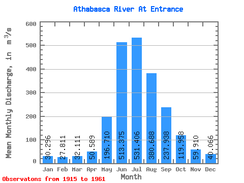
| Mean | 30.30 | 27.81 | 32.11 | 50.59 | 196.71 | 513.38 | 531.41 | 380.69 | 237.94 | 119.96 | 59.91 | 40.07 | 186.28 |
| Standard Deviation | 6.63 | 7.98 | 7.54 | 24.72 | 77.54 | 83.17 | 110.70 | 64.48 | 45.86 | 25.99 | 13.06 | 10.53 | 15.95 |
| Min | 18.30 | 11.60 | 14.70 | 22.60 | 86.80 | 347.00 | 355.00 | 256.00 | 156.00 | 75.40 | 37.60 | 24.50 | 159.08 |
| Max | 48.60 | 46.40 | 48.40 | 141.00 | 372.00 | 681.00 | 883.00 | 529.00 | 337.00 | 199.00 | 100.00 | 61.80 | 217.36 |
| Coefficient of Variation | 0.22 | 0.29 | 0.23 | 0.49 | 0.39 | 0.16 | 0.21 | 0.17 | 0.19 | 0.22 | 0.22 | 0.26 | 0.09 |
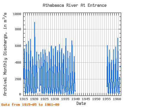
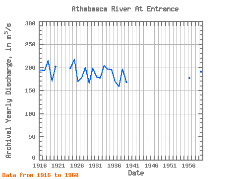
| Year | Jan | Feb | Mar | Apr | May | Jun | Jul | Aug | Sep | Oct | Nov | Dec | Annual | 1915 | 201.00 | 454.00 | 566.00 | 505.00 | 201.00 | 89.70 | 68.20 | 33.20 | 1916 | 24.40 | 25.70 | 31.00 | 42.70 | 104.00 | 526.00 | 620.00 | 425.00 | 272.00 | 147.00 | 67.10 | 38.70 | 193.63 | 1917 | 35.00 | 27.90 | 29.10 | 36.50 | 172.00 | 454.00 | 653.00 | 337.00 | 251.00 | 199.00 | 64.70 | 55.00 | 192.85 | 1918 | 48.60 | 37.30 | 48.40 | 61.10 | 161.00 | 681.00 | 657.00 | 421.00 | 266.00 | 111.00 | 50.50 | 30.00 | 214.41 | 1919 | 30.00 | 29.50 | 32.80 | 39.60 | 151.00 | 379.00 | 467.00 | 418.00 | 302.00 | 114.00 | 52.90 | 35.00 | 170.90 | 1920 | 26.50 | 30.10 | 27.90 | 34.00 | 90.20 | 358.00 | 883.00 | 529.00 | 215.00 | 138.00 | 52.90 | 38.80 | 201.95 | 1921 | 36.50 | 44.00 | 34.20 | 50.30 | 193.00 | 525.00 | 446.00 | 382.00 | 178.00 | 122.00 | 89.70 | 1922 | 489.00 | 447.00 | 417.00 | 239.00 | 100.00 | 54.00 | 1923 | 126.00 | 522.00 | 488.00 | 430.00 | 277.00 | 113.00 | 62.70 | 42.10 | 1924 | 27.50 | 28.30 | 34.60 | 35.40 | 234.00 | 467.00 | 554.00 | 440.00 | 337.00 | 141.00 | 50.60 | 26.10 | 197.96 | 1925 | 22.30 | 26.00 | 36.20 | 94.20 | 311.00 | 549.00 | 524.00 | 505.00 | 310.00 | 120.00 | 58.50 | 52.10 | 217.36 | 1926 | 30.80 | 32.90 | 40.80 | 91.90 | 202.00 | 357.00 | 475.00 | 319.00 | 259.00 | 129.00 | 64.20 | 32.80 | 169.53 | 1927 | 26.30 | 27.20 | 35.30 | 43.40 | 86.80 | 528.00 | 512.00 | 405.00 | 254.00 | 150.00 | 44.40 | 28.40 | 178.40 | 1928 | 40.30 | 28.90 | 43.40 | 45.90 | 307.00 | 577.00 | 601.00 | 373.00 | 218.00 | 85.30 | 48.30 | 29.80 | 199.82 | 1929 | 29.30 | 26.20 | 32.80 | 38.50 | 135.00 | 564.00 | 397.00 | 341.00 | 202.00 | 119.00 | 64.80 | 41.80 | 165.95 | 1930 | 27.40 | 27.10 | 29.70 | 61.70 | 164.00 | 580.00 | 592.00 | 427.00 | 272.00 | 98.90 | 59.80 | 36.80 | 198.03 | 1931 | 37.70 | 27.60 | 31.40 | 35.10 | 198.00 | 499.00 | 542.00 | 317.00 | 237.00 | 134.00 | 57.40 | 26.50 | 178.56 | 1932 | 23.90 | 28.50 | 25.80 | 60.00 | 172.00 | 615.00 | 437.00 | 411.00 | 200.00 | 82.10 | 38.10 | 24.50 | 176.49 | 1933 | 21.70 | 19.80 | 20.80 | 36.70 | 148.00 | 532.00 | 568.00 | 459.00 | 326.00 | 154.00 | 100.00 | 61.80 | 203.98 | 1934 | 26.70 | 22.50 | 31.90 | 141.00 | 372.00 | 504.00 | 462.00 | 346.00 | 184.00 | 149.00 | 76.60 | 40.80 | 196.38 | 1935 | 35.60 | 46.40 | 34.30 | 59.20 | 127.00 | 505.00 | 691.00 | 381.00 | 274.00 | 93.20 | 46.10 | 43.70 | 194.71 | 1936 | 28.10 | 11.60 | 14.70 | 72.70 | 274.00 | 536.00 | 364.00 | 331.00 | 156.00 | 137.00 | 69.90 | 43.30 | 169.86 | 1937 | 18.30 | 13.10 | 31.20 | 22.60 | 150.00 | 433.00 | 517.00 | 322.00 | 225.00 | 75.40 | 54.10 | 47.30 | 159.08 | 1938 | 38.00 | 24.00 | 18.50 | 30.50 | 206.00 | 663.00 | 559.00 | 303.00 | 278.00 | 117.00 | 63.70 | 57.50 | 196.52 | 1939 | 30.50 | 19.30 | 47.80 | 38.80 | 256.00 | 347.00 | 471.00 | 358.00 | 200.00 | 124.00 | 67.90 | 55.30 | 167.97 | 1955 | 114.00 | 589.00 | 605.00 | 336.00 | 194.00 | 83.10 | 37.60 | 34.00 | 1956 | 32.50 | 29.10 | 28.50 | 57.00 | 252.00 | 550.00 | 450.00 | 317.00 | 199.00 | 117.00 | 57.00 | 30.40 | 176.62 | 1957 | 27.10 | 35.80 | 34.60 | 35.70 | 369.00 | 429.00 | 355.00 | 256.00 | 216.00 | 105.00 | 63.80 | 33.70 | 163.39 | 1958 | 31.80 | 28.70 | 27.00 | 39.90 | 304.00 | 553.00 | 431.00 | 317.00 | 201.00 | 115.00 | 54.90 | 36.20 | 178.29 | 1959 | 30.00 | 21.60 | 34.60 | 41.60 | 180.00 | 587.00 | 555.00 | 334.00 | 274.00 | 126.00 | 54.80 | 55.40 | 191.17 | 1960 | 38.10 | 39.90 | 34.90 | 39.30 | 121.00 | 481.00 | 694.00 | 370.00 | 212.00 | 130.00 | 62.00 | 50.90 | 189.43 | 1961 | 23.40 | 19.70 | 26.90 | 31.20 | 217.00 | 595.00 | 422.00 | 350.00 | 185.00 |
|---|
 Return to R-Arctic Net Home Page