|
|
|||||||||||||||||
| Point ID: 5943 | Downloads | Plots | Site Data | Code: 1596 |
|
|
|||||||||||||||||
| Download | |
|---|---|
| Site Descriptor Information | Site Time Series Data |
| Link to all available data | |
|
|
| View: | Statistics | Time Series |
| Units: | mm |
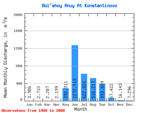
| Statistic | Jan | Feb | Mar | Apr | May | Jun | Jul | Aug | Sep | Oct | Nov | Dec | Annual |
|---|---|---|---|---|---|---|---|---|---|---|---|---|---|
| Mean | 3.99 | 2.71 | 2.29 | 2.20 | 292.31 | 1272.91 | 622.83 | 516.22 | 393.61 | 67.42 | 16.14 | 7.30 | 266.66 |
| Standard Deviation | 1.08 | 0.69 | 0.73 | 0.66 | 181.98 | 449.78 | 381.52 | 296.04 | 235.67 | 29.47 | 4.67 | 2.26 | 71.36 |
| Min | 1.33 | 1.10 | 1.05 | 0.65 | 2.46 | 499.00 | 112.00 | 146.00 | 158.00 | 34.90 | 9.49 | 3.92 | 157.62 |
| Max | 5.71 | 3.83 | 3.90 | 3.37 | 569.00 | 2050.00 | 1710.00 | 1310.00 | 1170.00 | 155.00 | 25.60 | 11.90 | 444.14 |
| Coefficient of Variation | 0.27 | 0.25 | 0.32 | 0.30 | 0.62 | 0.35 | 0.61 | 0.57 | 0.60 | 0.44 | 0.29 | 0.31 | 0.27 |
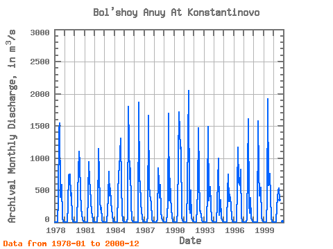
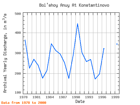
| Year | Jan | Feb | Mar | Apr | May | Jun | Jul | Aug | Sep | Oct | Nov | Dec | Annual | 1978 | 3.94 | 2.90 | 2.28 | 1.84 | 360.00 | 1410.00 | 1540.00 | 389.00 | 585.00 | 55.50 | 12.00 | 4.79 | 363.94 | 1979 | 1.33 | 1.10 | 1.05 | 0.65 | 271.00 | 738.00 | 746.00 | 411.00 | 455.00 | 57.40 | 15.40 | 7.34 | 225.44 | 1980 | 5.41 | 3.83 | 3.90 | 3.37 | 458.00 | 1100.00 | 916.00 | 480.00 | 206.00 | 46.00 | 12.40 | 5.20 | 270.01 | 1981 | 2.97 | 2.09 | 1.18 | 1.23 | 450.00 | 946.00 | 652.00 | 518.00 | 158.00 | 128.00 | 15.40 | 6.08 | 240.08 | 1982 | 3.49 | 2.91 | 2.83 | 2.41 | 161.00 | 1140.00 | 324.00 | 202.00 | 230.00 | 35.70 | 9.49 | 4.09 | 176.49 | 1983 | 2.58 | 2.24 | 1.92 | 2.04 | 382.00 | 786.00 | 411.00 | 537.00 | 306.00 | 109.00 | 17.00 | 8.33 | 213.76 | 1984 | 4.71 | 2.73 | 1.88 | 2.37 | 438.00 | 771.00 | 846.00 | 1310.00 | 589.00 | 155.00 | 25.60 | 9.05 | 346.28 | 1985 | 4.24 | 3.20 | 2.82 | 1.93 | 69.00 | 1800.00 | 674.00 | 844.00 | 288.00 | 51.20 | 14.50 | 8.77 | 313.47 | 1986 | 4.91 | 3.71 | 3.17 | 2.90 | 2.46 | 1870.00 | 638.00 | 637.00 | 287.00 | 65.70 | 19.70 | 8.50 | 295.25 | 1987 | 4.76 | 3.34 | 2.47 | 2.61 | 104.00 | 1660.00 | 560.00 | 338.00 | 314.00 | 47.60 | 12.40 | 4.96 | 254.51 | 1988 | 3.46 | 2.76 | 2.10 | 1.94 | 50.90 | 846.00 | 379.00 | 584.00 | 166.00 | 57.60 | 11.80 | 3.92 | 175.79 | 1989 | 2.50 | 1.92 | 2.15 | 2.41 | 284.00 | 1690.00 | 342.00 | 679.00 | 366.00 | 79.40 | 17.60 | 7.19 | 289.51 | 1990 | 3.44 | 2.03 | 1.99 | 3.24 | 178.00 | 995.00 | 1710.00 | 1150.00 | 1170.00 | 80.10 | 25.20 | 10.70 | 444.14 | 1991 | 4.72 | 1.98 | 1.28 | 1.45 | 569.00 | 2050.00 | 240.00 | 150.00 | 502.00 | 63.10 | 20.90 | 11.40 | 301.32 | 1992 | 5.23 | 3.81 | 2.74 | 2.41 | 468.00 | 1470.00 | 743.00 | 179.00 | 177.00 | 36.90 | 10.10 | 6.01 | 258.68 | 1993 | 4.14 | 2.66 | 2.77 | 2.66 | 483.00 | 1490.00 | 342.00 | 553.00 | 284.00 | 34.90 | 12.00 | 5.80 | 268.08 | 1994 | 4.06 | 2.90 | 3.21 | 2.15 | 293.00 | 992.00 | 112.00 | 215.00 | 348.00 | 69.40 | 13.40 | 5.92 | 171.75 | 1995 | 3.91 | 3.16 | 3.02 | 2.88 | 473.00 | 744.00 | 323.00 | 439.00 | 287.00 | 59.30 | 15.20 | 6.58 | 196.67 | 1996 | 2.99 | 2.74 | 2.04 | 1.77 | 542.00 | 1170.00 | 630.00 | 577.00 | 824.00 | 76.60 | 19.40 | 9.13 | 321.47 | 1997 | 5.18 | 3.33 | 2.65 | 2.77 | 56.60 | 1610.00 | 285.00 | 146.00 | 377.00 | 61.30 | 15.40 | 7.50 | 214.39 | 1998 | 3.35 | 2.17 | 1.21 | 1.29 | 6.20 | 1580.00 | 803.00 | 419.00 | 540.00 | 82.00 | 24.80 | 11.90 | 289.58 | 1999 | 5.71 | 2.07 | 1.62 | 1.94 | 371.00 | 1920.00 | 580.00 | 763.00 | 407.00 | 59.80 | 18.00 | 9.00 | 344.93 | 2000 | 4.65 | 2.76 | 2.33 | 2.31 | 253.00 | 499.00 | 529.00 | 353.00 | 187.00 | 39.20 | 13.60 | 5.65 | 157.62 |
|---|
 Return to R-Arctic Net Home Page