|
|
|||||||||||||||||
| Point ID: 5196 | Downloads | Plots | Site Data | Other Close Sites | Code: 05EG001 |
|
|
|||||||||||||||||
| Download | |
|---|---|
| Site Descriptor Information | Site Time Series Data |
| Link to all available data | |
|
|
| View: | Statistics | Time Series |
| Units: | mm |
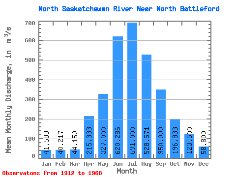
| Statistic | Jan | Feb | Mar | Apr | May | Jun | Jul | Aug | Sep | Oct | Nov | Dec | Annual |
|---|---|---|---|---|---|---|---|---|---|---|---|---|---|
| Mean | 41.58 | 40.22 | 44.15 | 215.33 | 327.00 | 620.29 | 691.00 | 528.57 | 350.00 | 196.83 | 123.50 | 58.80 | 290.13 |
| Standard Deviation | 10.84 | 7.31 | 7.32 | 55.79 | 163.61 | 165.99 | 165.18 | 158.58 | 137.41 | 52.75 | 28.73 | 10.89 | 27.60 |
| Min | 33.80 | 32.20 | 36.80 | 144.00 | 158.00 | 388.00 | 488.00 | 333.00 | 209.00 | 123.00 | 100.00 | 48.70 | 265.86 |
| Max | 61.20 | 51.40 | 55.60 | 272.00 | 628.00 | 879.00 | 959.00 | 765.00 | 583.00 | 278.00 | 165.00 | 76.50 | 314.69 |
| Coefficient of Variation | 0.26 | 0.18 | 0.17 | 0.26 | 0.50 | 0.27 | 0.24 | 0.30 | 0.39 | 0.27 | 0.23 | 0.18 | 0.10 |
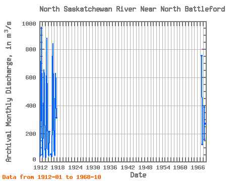
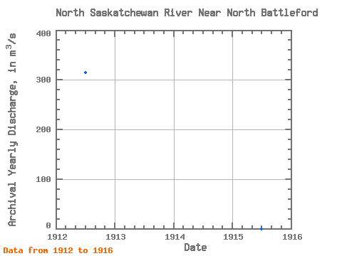
| Year | Jan | Feb | Mar | Apr | May | Jun | Jul | Aug | Sep | Oct | Nov | Dec | Annual | 1912 | 36.40 | 39.70 | 41.10 | 238.00 | 337.00 | 474.00 | 959.00 | 765.00 | 492.00 | 229.00 | 110.00 | 55.10 | 314.69 | 1913 | 34.50 | 44.00 | 55.60 | 272.00 | 274.00 | 565.00 | 654.00 | 612.00 | 336.00 | 182.00 | 100.00 | 61.20 | 265.86 | 1914 | 33.80 | 32.20 | 36.80 | 144.00 | 345.00 | 879.00 | 734.00 | 387.00 | 243.00 | 197.00 | 119.00 | 48.70 | 266.62 | 1915 | 47.50 | 41.60 | 49.40 | 212.00 | 52.50 | 1916 | 36.10 | 32.40 | 37.40 | 155.00 | 220.00 | 663.00 | 842.00 | 672.00 | 583.00 | 278.00 | 165.00 | 76.50 | 313.37 | 1917 | 61.20 | 51.40 | 44.60 | 271.00 | 628.00 | 618.00 | 578.00 | 441.00 | 315.00 | 1967 | 755.00 | 582.00 | 333.00 | 209.00 | 123.00 | 1968 | 158.00 | 388.00 | 488.00 | 490.00 | 272.00 | 172.00 |
|---|
| Other Close Sites | ||||||
|---|---|---|---|---|---|---|
| PointID | Latitude | Longitude | Drainage Area | Source | Name | |
| 5204 | "BATTLE RIVER AT BATTLEFORD" | 52.73 | 1280508 | Hydat | ||
 Return to R-Arctic Net Home Page