|
|
|||||||||||||||||
| Point ID: 5196 | Downloads | Plots | Site Data | Other Close Sites | Code: 05EG001 |
|
|
|||||||||||||||||
| Download | |
|---|---|
| Site Descriptor Information | Site Time Series Data |
| Link to all available data | |
|
|
| View: | Statistics | Time Series |
| Units: | m3/s |
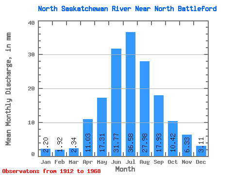
| Statistic | Jan | Feb | Mar | Apr | May | Jun | Jul | Aug | Sep | Oct | Nov | Dec | Annual |
|---|---|---|---|---|---|---|---|---|---|---|---|---|---|
| Mean | 1.59 | 1.40 | 1.69 | 7.99 | 12.53 | 23.00 | 26.47 | 20.25 | 12.98 | 7.54 | 4.58 | 2.25 | 131.00 |
| Standard Deviation | 0.41 | 0.26 | 0.28 | 2.07 | 6.27 | 6.16 | 6.33 | 6.08 | 5.09 | 2.02 | 1.07 | 0.42 | 12.46 |
| Min | 1.29 | 1.12 | 1.41 | 5.34 | 6.05 | 14.39 | 18.70 | 12.76 | 7.75 | 4.71 | 3.71 | 1.87 | 120.04 |
| Max | 2.34 | 1.79 | 2.13 | 10.09 | 24.06 | 32.59 | 36.74 | 29.31 | 21.62 | 10.65 | 6.12 | 2.93 | 142.08 |
| Coefficient of Variation | 0.26 | 0.18 | 0.17 | 0.26 | 0.50 | 0.27 | 0.24 | 0.30 | 0.39 | 0.27 | 0.23 | 0.18 | 0.10 |
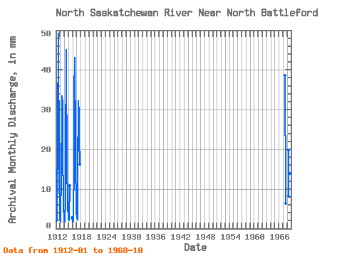
| Year | Jan | Feb | Mar | Apr | May | Jun | Jul | Aug | Sep | Oct | Nov | Dec | Annual | 1912 | 1.40 | 1.39 | 1.57 | 8.82 | 12.91 | 17.58 | 36.74 | 29.31 | 18.24 | 8.77 | 4.08 | 2.11 | 142.08 | 1913 | 1.32 | 1.54 | 2.13 | 10.09 | 10.50 | 20.95 | 25.06 | 23.45 | 12.46 | 6.97 | 3.71 | 2.34 | 120.04 | 1914 | 1.29 | 1.12 | 1.41 | 5.34 | 13.22 | 32.59 | 28.12 | 14.83 | 9.01 | 7.55 | 4.41 | 1.87 | 120.38 | 1915 | 1.82 | 1.45 | 1.89 | 7.86 | 2.01 | 1916 | 1.38 | 1.13 | 1.43 | 5.75 | 8.43 | 24.59 | 32.26 | 25.75 | 21.62 | 10.65 | 6.12 | 2.93 | 141.49 | 1917 | 2.34 | 1.79 | 1.71 | 10.05 | 24.06 | 22.92 | 22.14 | 16.90 | 11.68 | 1967 | 28.00 | 22.30 | 12.76 | 7.75 | 4.71 | 1968 | 6.05 | 14.39 | 18.70 | 18.77 | 10.09 | 6.59 |
|---|
| Other Close Sites | ||||||
|---|---|---|---|---|---|---|
| PointID | Latitude | Longitude | Drainage Area | Source | Name | |
| 5204 | "BATTLE RIVER AT BATTLEFORD" | 52.73 | 1280508 | Hydat | ||
 Return to R-Arctic Net Home Page