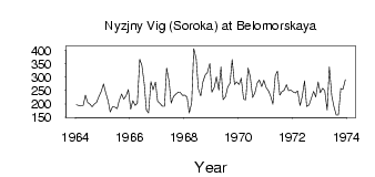
| PointID: | 7302 | Code: | 49081 | Latitude (decimal degrees): | 64.52 | Longitude (decimal degrees): | 34.70 | Drainage Area (km2): | 27000.00 | Source: | SHI | Hydrological Zone: | North European Russia | Name: | Nyzjny Vig (Soroka) at Belomorskaya |
|---|
| Download | |
|---|---|
| Site Descriptor Information | Site Time Series Data |
| Link to all available data | |
| ID | Year | Jan | Feb | Mar | Apr | May | Jun | Jul | Aug | Sep | Oct | Nov | Dec |
|---|---|---|---|---|---|---|---|---|---|---|---|---|---|
| 7302 | 1964 | 197.00 | 194.00 | 192.00 | 195.00 | 233.00 | 206.00 | 199.00 | 189.00 | 200.00 | 206.00 | 229.00 | 245.00 |
| 7302 | 1965 | 274.00 | 242.00 | 212.00 | 170.00 | 189.00 | 188.00 | 182.00 | 213.00 | 236.00 | 218.00 | 231.00 | 253.00 |
| 7302 | 1966 | 180.00 | 212.00 | 194.00 | 203.00 | 366.00 | 343.00 | 274.00 | 177.00 | 166.00 | 283.00 | 252.00 | 281.00 |
| 7302 | 1967 | 210.00 | 202.00 | 192.00 | 191.00 | 333.00 | 285.00 | 203.00 | 228.00 | 235.00 | 243.00 | 242.00 | 232.00 |
| 7302 | 1968 | 233.00 | 224.00 | 166.00 | 205.00 | 406.00 | 368.00 | 256.00 | 230.00 | 281.00 | 308.00 | 317.00 | 350.00 |
| 7302 | 1969 | 243.00 | 261.00 | 301.00 | 251.00 | 337.00 | 216.00 | 227.00 | 261.00 | 277.00 | 365.00 | 272.00 | 282.00 |
| 7302 | 1970 | 272.00 | 296.00 | 218.00 | 215.00 | 333.00 | 301.00 | 224.00 | 239.00 | 277.00 | 289.00 | 264.00 | 288.00 |
| 7302 | 1971 | 260.00 | 249.00 | 228.00 | 199.00 | 305.00 | 322.00 | 233.00 | 245.00 | 250.00 | 271.00 | 249.00 | 251.00 |
| 7302 | 1972 | 244.00 | 240.00 | 248.00 | 194.00 | 227.00 | 286.00 | 190.00 | 196.00 | 220.00 | 246.00 | 226.00 | 282.00 |
| 7302 | 1973 | 241.00 | 258.00 | 248.00 | 177.00 | 337.00 | 231.00 | 191.00 | 158.00 | 158.00 | 257.00 | 254.00 | 290.00 |
| Other Close Sites | ||||||
|---|---|---|---|---|---|---|
| PointID | Latitude | Longitude | Drainage Area | Source | Name | |
| 7300 | 64.43 | 34.50 | 26500.00 | SHI | Belomorkanal at Matkozj | |
| 7301 | 64.48 | 34.67 | 26600.00 | SHI | Nyzjny Vig (Soroka) at Vigostrov | |
 Return to R-Arctic Net Home Page