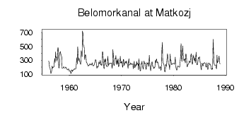
| PointID: | 7300 | Code: | 49076 | Latitude (decimal degrees): | 64.43 | Longitude (decimal degrees): | 34.50 | Drainage Area (km2): | 26500.00 | Source: | SHI | Hydrological Zone: | North European Russia | Name: | Belomorkanal at Matkozj |
|---|
| Download | |
|---|---|
| Site Descriptor Information | Site Time Series Data |
| Link to all available data | |
| ID | Year | Jan | Feb | Mar | Apr | May | Jun | Jul | Aug | Sep | Oct | Nov | Dec |
|---|---|---|---|---|---|---|---|---|---|---|---|---|---|
| 7300 | 1956 | 286.00 | 260.00 | 197.00 | 187.00 | 154.00 | 109.00 | 116.00 | 151.00 | 216.00 | 185.00 | 201.00 | 196.00 |
| 7300 | 1957 | 204.00 | 271.00 | 327.00 | 264.00 | 418.00 | 339.00 | 343.00 | 286.00 | 330.00 | 478.00 | 480.00 | 198.00 |
| 7300 | 1958 | 185.00 | 239.00 | 411.00 | 424.00 | 383.00 | 374.00 | 344.00 | 182.00 | 182.00 | 184.00 | 201.00 | 205.00 |
| 7300 | 1959 | 187.00 | 188.00 | 187.00 | 202.00 | 194.00 | 183.00 | 172.00 | 162.00 | 160.00 | 170.00 | 174.00 | 146.00 |
| 7300 | 1960 | 144.00 | 149.00 | 145.00 | 109.00 | 108.00 | 160.00 | 158.00 | 138.00 | 153.00 | 159.00 | 170.00 | 167.00 |
| 7300 | 1961 | 176.00 | 174.00 | 171.00 | 177.00 | 286.00 | 333.00 | 246.00 | 492.00 | 385.00 | 290.00 | 325.00 | 293.00 |
| 7300 | 1962 | 274.00 | 244.00 | 240.00 | 437.00 | 409.00 | 350.00 | 720.00 | 686.00 | 525.00 | 509.00 | 469.00 | 307.00 |
| 7300 | 1963 | 373.00 | 380.00 | 344.00 | 273.00 | 263.00 | 248.00 | 233.00 | 214.00 | 221.00 | 230.00 | 229.00 | 250.00 |
| 7300 | 1964 | 236.00 | 239.00 | 231.00 | 230.00 | 263.00 | 236.00 | 226.00 | 216.00 | 226.00 | 232.00 | 259.00 | 283.00 |
| 7300 | 1965 | 309.00 | 298.00 | 249.00 | 183.00 | 207.00 | 208.00 | 200.00 | 237.00 | 276.00 | 245.00 | 266.00 | 298.00 |
| 7300 | 1966 | 230.00 | 247.00 | 224.00 | 230.00 | 422.00 | 417.00 | 310.00 | 193.00 | 177.00 | 315.00 | 274.00 | 322.00 |
| 7300 | 1967 | 233.00 | 222.00 | 213.00 | 203.00 | 355.00 | 307.00 | 216.00 | 245.00 | 248.00 | 258.00 | 257.00 | 250.00 |
| 7300 | 1968 | 253.00 | 256.00 | 182.00 | 225.00 | 453.00 | 380.00 | 247.00 | 220.00 | 276.00 | 324.00 | 319.00 | 365.00 |
| 7300 | 1969 | 239.00 | 255.00 | 301.00 | 239.00 | 321.00 | 203.00 | 213.00 | 257.00 | 260.00 | 355.00 | 261.00 | 276.00 |
| 7300 | 1970 | 257.00 | 287.00 | 201.00 | 200.00 | 312.00 | 307.00 | 223.00 | 239.00 | 261.00 | 279.00 | 257.00 | 289.00 |
| 7300 | 1971 | 257.00 | 248.00 | 228.00 | 182.00 | 277.00 | 320.00 | 228.00 | 233.00 | 244.00 | 263.00 | 238.00 | 245.00 |
| 7300 | 1972 | 243.00 | 239.00 | 248.00 | 176.00 | 206.00 | 285.00 | 192.00 | 199.00 | 220.00 | 240.00 | 217.00 | 283.00 |
| 7300 | 1973 | 238.00 | 256.00 | 240.00 | 162.00 | 322.00 | 222.00 | 189.00 | 146.00 | 150.00 | 250.00 | 248.00 | 285.00 |
| 7300 | 1974 | 220.00 | 192.00 | 170.00 | 234.00 | 290.00 | 251.00 | 251.00 | 258.00 | 168.00 | 176.00 | 263.00 | 262.00 |
| 7300 | 1975 | 242.00 | 259.00 | 212.00 | 222.00 | 369.00 | 245.00 | 191.00 | 149.00 | 199.00 | 244.00 | 273.00 | 275.00 |
| 7300 | 1976 | 211.00 | 210.00 | 179.00 | 194.00 | 189.00 | 205.00 | 298.00 | 259.00 | 309.00 | 317.00 | 263.00 | 275.00 |
| 7300 | 1977 | 270.00 | 225.00 | 184.00 | 187.00 | 183.00 | 211.00 | 192.00 | 150.00 | 229.00 | 443.00 | 556.00 | 296.00 |
| 7300 | 1978 | 256.00 | 251.00 | 231.00 | 166.00 | 129.00 | 162.00 | 241.00 | 210.00 | 255.00 | 342.00 | 391.00 | 348.00 |
| 7300 | 1979 | 244.00 | 243.00 | 207.00 | 165.00 | 388.00 | 296.00 | 297.00 | 235.00 | 247.00 | 240.00 | 248.00 | 252.00 |
| 7300 | 1980 | 252.00 | 254.00 | 241.00 | 280.00 | 344.00 | 211.00 | 179.00 | 157.00 | 160.00 | 215.00 | 217.00 | 217.00 |
| 7300 | 1981 | 203.00 | 199.00 | 201.00 | 260.00 | 358.00 | 538.00 | 364.00 | 279.00 | 344.00 | 505.00 | 379.00 | 320.00 |
| 7300 | 1982 | 290.00 | 311.00 | 319.00 | 261.00 | 390.00 | 384.00 | 314.00 | 207.00 | 208.00 | 238.00 | 240.00 | 257.00 |
| 7300 | 1983 | 293.00 | 274.00 | 268.00 | 283.00 | 378.00 | 391.00 | 312.00 | 240.00 | 254.00 | 375.00 | 340.00 | 349.00 |
| 7300 | 1984 | 293.00 | 326.00 | 266.00 | 336.00 | 415.00 | 244.00 | 233.00 | 235.00 | 268.00 | 341.00 | 325.00 | 329.00 |
| 7300 | 1985 | 350.00 | 279.00 | 231.00 | 189.00 | 161.00 | 255.00 | 249.00 | 230.00 | 215.00 | 255.00 | 254.00 | 262.00 |
| 7300 | 1986 | 265.00 | 248.00 | 212.00 | 202.00 | 204.00 | 263.00 | 184.00 | 165.00 | 201.00 | 260.00 | 254.00 | 237.00 |
| 7300 | 1987 | 240.00 | 242.00 | 210.00 | 174.00 | 165.00 | 184.00 | 169.00 | 599.00 | 463.00 | 287.00 | 233.00 | 225.00 |
| 7300 | 1988 | 230.00 | 231.00 | 189.00 | 175.00 | 372.00 | 259.00 | 280.00 | 281.00 | 323.00 | 361.00 | 266.00 | 246.00 |
| Other Close Sites | ||||||
|---|---|---|---|---|---|---|
| PointID | Latitude | Longitude | Drainage Area | Source | Name | |
| 7301 | 64.48 | 34.67 | 26600.00 | SHI | Nyzjny Vig (Soroka) at Vigostrov | |
| 7302 | 64.52 | 34.70 | 27000.00 | SHI | Nyzjny Vig (Soroka) at Belomorskaya | |
 Return to R-Arctic Net Home Page