Konda at Mejdurechenskyi
Ob
| PointID: | 7092 |
Code: | 11522 |
Latitude (decimal degrees): | 60.15 |
Longitude (decimal degrees): | 64.83 |
Drainage Area (km2): | 41200.00 |
Source: | SHI |
Hydrological Zone: | Ob |
Name: | Konda at Mejdurechenskyi |
Field Definitions
Site Time Series Plot:
Site Data File:
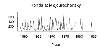
(Units: m3/s)
| ID | Year | Jan | Feb | Mar | Apr | May | Jun | Jul | Aug | Sep | Oct | Nov | Dec |
|---|
| 7092 | 1958 | | | | | | | | | 104.00 | 164.00 | 167.00 | 104.00 |
| 7092 | 1959 | 59.60 | 39.80 | 44.80 | 87.50 | 334.00 | 343.00 | 237.00 | 157.00 | 132.00 | 152.00 | 95.70 | 71.50 |
| 7092 | 1960 | 55.50 | 51.50 | 51.10 | 137.00 | 475.00 | 506.00 | 376.00 | 204.00 | 135.00 | 121.00 | 92.90 | 62.30 |
| 7092 | 1961 | 51.50 | 46.60 | 56.50 | 171.00 | 350.00 | 428.00 | 359.00 | 214.00 | 185.00 | 187.00 | 132.00 | 82.40 |
| 7092 | 1962 | 62.30 | 59.50 | 58.20 | 166.00 | 441.00 | 412.00 | 269.00 | 180.00 | 196.00 | 210.00 | 156.00 | 92.20 |
| 7092 | 1963 | 51.30 | 49.40 | 45.60 | 69.10 | 372.00 | 441.00 | 366.00 | 207.00 | 102.00 | 76.90 | 50.70 | 45.80 |
| 7092 | 1964 | 42.40 | 36.60 | 36.90 | 47.40 | 238.00 | | | 195.00 | 127.00 | 143.00 | 115.00 | 84.80 |
| 7092 | 1965 | 64.00 | 56.30 | 54.50 | 76.60 | 514.00 | 766.00 | 594.00 | 369.00 | 219.00 | 186.00 | 150.00 | 98.90 |
| 7092 | 1966 | 62.00 | 47.20 | 49.00 | 116.00 | 480.00 | 626.00 | 514.00 | 317.00 | 184.00 | 123.00 | 99.80 | 63.30 |
| 7092 | 1967 | 39.00 | 42.00 | 46.30 | 146.00 | 221.00 | 166.00 | 98.90 | 87.00 | 92.80 | 81.40 | 71.60 | 48.60 |
| 7092 | 1968 | 42.80 | 42.50 | 44.00 | 103.00 | 237.00 | 264.00 | 222.00 | 191.00 | 142.00 | 109.00 | 73.10 | 48.80 |
| 7092 | 1969 | 40.60 | 34.00 | 35.20 | 63.60 | 351.00 | 525.00 | 585.00 | 584.00 | 447.00 | 295.00 | 179.00 | 126.00 |
| 7092 | 1970 | 62.00 | 50.20 | 55.40 | 115.00 | 408.00 | 546.00 | 472.00 | 381.00 | 293.00 | 204.00 | 152.00 | 112.00 |
| 7092 | 1971 | 66.90 | 55.20 | 46.80 | 107.00 | 427.00 | 564.00 | 549.00 | 524.00 | 473.00 | 385.00 | 296.00 | 194.00 |
| 7092 | 1972 | 127.00 | 76.00 | 62.80 | 173.00 | 391.00 | 414.00 | 374.00 | 276.00 | 153.00 | 175.00 | 144.00 | 105.00 |
| 7092 | 1973 | 63.90 | 50.50 | 50.30 | 209.00 | 560.00 | 534.00 | 321.00 | 228.00 | 219.00 | 267.00 | 190.00 | 179.00 |
| 7092 | 1974 | 132.00 | 78.10 | 68.10 | 135.00 | 557.00 | 704.00 | 520.00 | 277.00 | 145.00 | 82.30 | 62.20 | 52.50 |
| 7092 | 1975 | 51.10 | 52.90 | 58.00 | 191.00 | 306.00 | 318.00 | 241.00 | 144.00 | 112.00 | 110.00 | 88.90 | 74.40 |
| 7092 | 1976 | 63.00 | 59.00 | 61.30 | 112.00 | 435.00 | 552.00 | 475.00 | 334.00 | 202.00 | 86.90 | 61.90 | 59.20 |
| 7092 | 1977 | 40.70 | 46.40 | 53.80 | 132.00 | 267.00 | 218.00 | 122.00 | 83.60 | 87.80 | 77.80 | 55.30 | 51.10 |
| 7092 | 1978 | | | | | 205.00 | 264.00 | 308.00 | 355.00 | 390.00 | | | |
| 7092 | 1980 | | | | | | 531.00 | 372.00 | 255.00 | 241.00 | 231.00 | 140.00 | 108.00 |
| 7092 | 1981 | 81.80 | 66.50 | 51.70 | 95.70 | 389.00 | | | | | | | |
| 7092 | 1984 | | | | | 273.00 | 374.00 | 264.00 | 139.00 | 103.00 | | | |
| Other Close Sites |
|---|
| PointID |
Latitude |
Longitude | Drainage Area | Source |
Name |
|---|
| 7091 | 60.15 | 64.83 | 23400.00 | SHI | Konda at Urai |
 Return to R-Arctic Net Home Page