Biya at Artibash
Ob
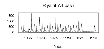
| PointID: | 6929 |
Code: | 10594 |
Latitude (decimal degrees): | 51.80 |
Longitude (decimal degrees): | 87.25 |
Drainage Area (km2): | 20100.00 |
Source: | SHI |
Hydrological Zone: | Ob |
Name: | Biya at Artibash |
Field Definitions
Site Time Series Plot:
Site Data File:
(Units: m3/s)
| ID | Year | Jan | Feb | Mar | Apr | May | Jun | Jul | Aug | Sep | Oct | Nov | Dec |
|---|
| 6929 | 1962 | | | | | | 544.00 | 312.00 | 213.00 | 162.00 | 144.00 | 93.80 | 57.30 |
| 6929 | 1963 | 44.10 | 35.50 | 32.30 | 31.40 | 159.00 | 667.00 | 336.00 | 169.00 | 143.00 | 111.00 | 81.50 | 51.70 |
| 6929 | 1965 | 41.50 | 32.20 | 29.00 | 34.30 | 479.00 | 458.00 | 275.00 | 193.00 | 273.00 | 185.00 | 107.00 | 70.00 |
| 6929 | 1966 | 46.40 | 39.90 | 38.70 | 51.20 | 269.00 | 1700.00 | 648.00 | 366.00 | 217.00 | 154.00 | 85.70 | 48.90 |
| 6929 | 1967 | 38.50 | 33.20 | 31.30 | 37.80 | 337.00 | 605.00 | 602.00 | 736.00 | 402.00 | 204.00 | 109.00 | 61.90 |
| 6929 | 1968 | 36.70 | 34.20 | 30.00 | 33.70 | 605.00 | 449.00 | 222.00 | 171.00 | 173.00 | 126.00 | 69.00 | 59.10 |
| 6929 | 1969 | 39.90 | 34.10 | 28.90 | 58.70 | 735.00 | 1340.00 | 566.00 | 357.00 | 299.00 | 237.00 | 156.00 | 102.00 |
| 6929 | 1970 | 53.80 | 44.00 | 39.10 | 48.00 | 503.00 | 839.00 | 473.00 | 349.00 | 274.00 | 170.00 | 100.00 | 48.40 |
| 6929 | 1971 | 38.80 | 30.90 | 24.30 | 39.60 | 314.00 | 486.00 | 411.00 | 226.00 | 149.00 | 123.00 | 76.40 | 44.10 |
| 6929 | 1972 | 28.90 | 24.80 | 24.10 | 40.10 | 462.00 | 634.00 | 449.00 | 307.00 | 273.00 | 170.00 | 103.00 | 68.00 |
| 6929 | 1973 | 43.10 | 32.40 | 27.60 | 46.30 | 265.00 | 1170.00 | 653.00 | 390.00 | 294.00 | 175.00 | 95.30 | 58.80 |
| 6929 | 1974 | 43.10 | 31.60 | 28.10 | 51.50 | 420.00 | 566.00 | 285.00 | 157.00 | 154.00 | 178.00 | 96.70 | 50.40 |
| 6929 | 1975 | 36.50 | 30.00 | 23.20 | 29.00 | 148.00 | 1340.00 | 631.00 | 289.00 | 181.00 | 124.00 | 75.50 | 41.60 |
| 6929 | 1976 | 27.40 | 20.30 | 17.00 | 25.70 | 501.00 | 690.00 | 424.00 | 412.00 | 205.00 | 155.00 | 86.30 | 52.80 |
| 6929 | 1977 | 38.50 | 32.80 | 28.40 | 84.30 | 351.00 | 725.00 | 381.00 | 329.00 | 293.00 | 199.00 | 110.00 | 66.60 |
| 6929 | 1978 | 45.70 | 37.60 | 30.70 | 73.20 | 363.00 | 619.00 | 334.00 | 380.00 | 221.00 | 129.00 | 74.30 | 45.10 |
| 6929 | 1979 | 30.40 | 27.90 | 29.70 | 39.10 | 364.00 | 569.00 | 312.00 | 221.00 | 361.00 | 174.00 | 117.00 | 62.70 |
| 6929 | 1980 | 40.00 | 32.00 | 27.20 | 38.00 | 540.00 | 650.00 | 525.00 | 310.00 | 220.00 | 131.00 | 82.60 | 54.00 |
| 6929 | 1981 | 38.10 | 29.30 | 27.00 | 48.80 | 516.00 | 460.00 | 258.00 | 297.00 | 319.00 | 182.00 | 99.00 | 57.80 |
| 6929 | 1982 | 40.80 | 32.90 | 28.00 | 84.40 | 548.00 | 672.00 | 362.00 | 359.00 | 194.00 | 153.00 | 112.00 | 62.20 |
| 6929 | 1983 | 44.70 | 32.60 | 31.70 | 40.00 | 292.00 | 742.00 | 532.00 | 458.00 | 255.00 | 214.00 | 124.00 | 71.10 |
| 6929 | 1984 | 43.40 | 31.50 | 24.90 | 32.70 | 336.00 | 975.00 | 918.00 | 824.00 | 286.00 | 187.00 | 107.00 | 60.90 |
| 6929 | 1985 | 39.20 | 34.20 | 24.70 | 53.30 | 391.00 | 769.00 | 614.00 | 421.00 | 300.00 | 168.00 | 94.40 | 62.10 |
| 6929 | 1990 | 34.70 | 30.00 | 29.50 | 39.40 | 357.00 | 608.00 | 442.00 | 581.00 | 322.00 | 170.00 | 96.70 | 58.10 |
| Other Close Sites |
|---|
| PointID |
Latitude |
Longitude | Drainage Area | Source |
Name |
|---|
| 6668 | 51.90 | 87.10 | 21000.00 | SHI | Biya at Kebezen' |
 Return to R-Arctic Net Home Page