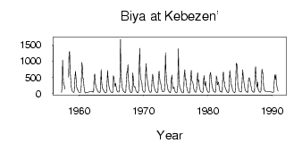
Biya at Kebezen'
Ob
| PointID: | 6668 |
Code: | 10042 |
Latitude (decimal degrees): | 51.90 |
Longitude (decimal degrees): | 87.10 |
Drainage Area (km2): | 21000.00 |
Source: | SHI |
Hydrological Zone: | Ob |
Name: | Biya at Kebezen' |
Field Definitions
Site Time Series Plot:
Site Data File:
(Units: m3/s)
| ID | Year | Jan | Feb | Mar | Apr | May | Jun | Jul | Aug | Sep | Oct | Nov | Dec |
|---|
| 6668 | 1957 | | | | 41.70 | 246.00 | 1030.00 | 492.00 | 274.00 | 250.00 | 147.00 | | |
| 6668 | 1958 | | | | | 503.00 | 1230.00 | 1300.00 | 732.00 | 434.00 | 218.00 | 118.00 | 73.40 |
| 6668 | 1959 | 55.30 | 41.90 | 37.20 | 115.00 | 515.00 | 684.00 | 468.00 | 231.00 | 169.00 | 123.00 | 85.40 | 50.40 |
| 6668 | 1960 | 36.30 | 33.50 | 34.20 | 51.50 | 230.00 | 959.00 | 790.00 | 467.00 | 460.00 | 205.00 | 98.00 | 22.80 |
| 6668 | 1962 | 72.80 | 58.00 | 39.60 | 82.40 | 513.00 | 603.00 | 365.00 | 237.00 | 175.00 | 157.00 | 100.00 | 62.70 |
| 6668 | 1963 | 47.00 | 39.20 | 38.70 | 47.00 | 232.00 | 743.00 | 386.00 | 185.00 | 157.00 | 114.00 | 85.50 | 56.30 |
| 6668 | 1964 | 37.70 | 20.30 | 26.10 | 43.40 | 286.00 | 715.00 | 487.00 | 295.00 | 199.00 | 134.00 | 80.60 | 60.30 |
| 6668 | 1965 | 47.50 | 42.90 | 31.00 | 62.20 | 551.00 | 473.00 | 298.00 | 217.00 | 317.00 | 212.00 | 121.00 | 77.70 |
| 6668 | 1966 | 58.50 | 49.30 | 46.60 | 84.70 | 370.00 | 1670.00 | 692.00 | 398.00 | 217.00 | 149.00 | 94.80 | 70.30 |
| 6668 | 1967 | 56.10 | 36.90 | 32.20 | 77.60 | 359.00 | 670.00 | 639.00 | 890.00 | 434.00 | 239.00 | 134.00 | 71.60 |
| 6668 | 1968 | 46.60 | 30.00 | 33.10 | 71.50 | 644.00 | 477.00 | 248.00 | 198.00 | 210.00 | 158.00 | 92.10 | 59.00 |
| 6668 | 1969 | 45.40 | 32.90 | 30.80 | 101.00 | 841.00 | 1390.00 | 651.00 | 440.00 | 402.00 | 317.00 | 153.00 | 83.20 |
| 6668 | 1970 | 55.80 | 44.20 | 41.30 | 86.30 | 601.00 | 925.00 | 551.00 | 430.00 | 341.00 | 217.00 | 120.00 | 70.10 |
| 6668 | 1971 | 44.60 | 48.70 | 42.90 | 92.30 | 416.00 | 596.00 | 511.00 | 272.00 | 187.00 | 150.00 | 89.50 | 59.90 |
| 6668 | 1972 | 41.80 | 34.40 | 30.90 | 88.90 | 512.00 | 693.00 | 520.00 | 356.00 | 329.00 | 236.00 | 133.00 | 75.50 |
| 6668 | 1973 | 55.00 | 53.80 | 52.30 | 92.60 | 341.00 | 1250.00 | 712.00 | 392.00 | 290.00 | 181.00 | 115.00 | 73.70 |
| 6668 | 1974 | 53.20 | 37.90 | 30.10 | 98.90 | 430.00 | 567.00 | 279.00 | 156.00 | 170.00 | 202.00 | 107.00 | 59.80 |
| 6668 | 1975 | 40.90 | 32.90 | 25.20 | 66.10 | 221.00 | 1380.00 | 607.00 | 284.00 | 189.00 | 156.00 | 94.30 | 59.20 |
| 6668 | 1976 | 38.40 | 29.00 | 21.20 | 56.60 | 562.00 | 732.00 | 443.00 | 451.00 | 223.00 | 188.00 | 100.00 | 63.40 |
| 6668 | 1977 | 29.20 | 22.40 | 30.20 | 126.00 | 413.00 | 718.00 | 409.00 | 372.00 | 343.00 | 250.00 | 140.00 | 85.30 |
| 6668 | 1978 | 59.40 | 50.50 | 38.90 | 133.00 | 401.00 | 648.00 | 366.00 | 421.00 | 247.00 | 152.00 | 97.10 | 62.60 |
| 6668 | 1979 | 62.40 | 40.70 | 29.40 | 62.20 | 395.00 | 558.00 | 315.00 | 243.00 | 379.00 | 199.00 | 147.00 | 91.10 |
| 6668 | 1980 | 61.10 | 44.80 | 34.10 | 66.20 | 567.00 | 657.00 | 550.00 | 339.00 | 247.00 | 152.00 | 106.00 | 66.80 |
| 6668 | 1981 | 53.50 | 49.60 | 38.40 | 109.00 | 542.00 | 467.00 | 271.00 | 321.00 | 356.00 | 200.00 | 116.00 | 68.40 |
| 6668 | 1982 | 53.60 | 58.70 | 42.30 | 116.00 | 548.00 | 667.00 | 377.00 | 380.00 | 206.00 | 171.00 | 123.00 | 73.40 |
| 6668 | 1983 | 52.20 | 40.20 | 31.40 | 53.70 | 337.00 | 716.00 | 508.00 | 438.00 | 263.00 | 226.00 | 128.00 | 74.50 |
| 6668 | 1984 | 59.40 | 35.20 | 28.50 | 59.80 | 333.00 | 933.00 | 920.00 | 799.00 | 282.00 | 185.00 | 114.00 | 69.20 |
| 6668 | 1985 | 69.70 | 60.30 | 46.40 | 76.90 | 378.00 | 736.00 | 562.00 | 391.00 | 289.00 | 166.00 | 106.00 | 72.50 |
| 6668 | 1986 | 60.10 | 52.20 | 36.90 | 62.80 | 427.00 | 491.00 | 467.00 | 372.00 | 287.00 | 194.00 | 111.00 | 72.30 |
| 6668 | 1987 | 58.10 | 49.00 | 40.30 | 64.70 | 529.00 | 832.00 | 553.00 | 293.00 | 196.00 | 359.00 | 130.00 | 86.90 |
| 6668 | 1988 | 63.60 | 50.50 | 41.90 | 83.50 | 468.00 | 751.00 | 639.00 | 634.00 | 254.00 | 143.00 | 101.00 | 73.20 |
| 6668 | 1990 | 48.30 | 36.80 | 33.50 | 71.50 | 374.00 | 573.00 | 444.00 | 585.00 | 340.00 | 205.00 | 126.00 | 79.30 |
| Other Close Sites |
|---|
| PointID |
Latitude |
Longitude | Drainage Area | Source |
Name |
|---|
| 6929 | 51.80 | 87.25 | 20100.00 | SHI | Biya at Artibash |
 Return to R-Arctic Net Home Page