Nuya at Naahara
Lena
| PointID: | 6325 |
Code: | 3574 |
Latitude (decimal degrees): | 60.45 |
Longitude (decimal degrees): | 114.33 |
Drainage Area (km2): | 23200.00 |
Source: | SHI |
Hydrological Zone: | Lena |
Name: | Nuya at Naahara |
Field Definitions
Site Time Series Plot:
Site Data File:
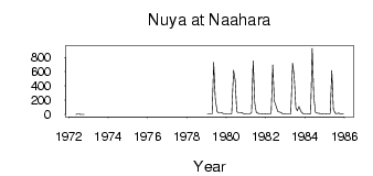
(Units: m3/s)
| ID | Year | Jan | Feb | Mar | Apr | May | Jun | Jul | Aug | Sep | Oct | Nov | Dec |
|---|
| 6325 | 1972 | | | | | 0.67 | 3.61 | 4.77 | 1.34 | 0.12 | 0.02 | | |
| 6325 | 1979 | 9.13 | 9.39 | 10.10 | 10.30 | 730.00 | 219.00 | 42.50 | 20.30 | 21.50 | 23.20 | 12.10 | 11.00 |
| 6325 | 1980 | 8.84 | 7.64 | 9.13 | 13.60 | 622.00 | 483.00 | 41.50 | 24.10 | 23.90 | 26.90 | 13.90 | 9.14 |
| 6325 | 1981 | 5.23 | 3.47 | 3.08 | 30.80 | 755.00 | 160.00 | 28.80 | 14.60 | 13.00 | 10.90 | 9.95 | 10.80 |
| 6325 | 1982 | 7.57 | 11.00 | 12.20 | 15.60 | 696.00 | 188.00 | 114.00 | 40.20 | 32.90 | 26.20 | 12.60 | 8.44 |
| 6325 | 1983 | 5.53 | 5.99 | 6.07 | 4.37 | 719.00 | 539.00 | 97.60 | 52.00 | 113.00 | 44.50 | 15.70 | 12.90 |
| 6325 | 1984 | 9.63 | 7.77 | 5.64 | 7.72 | 929.00 | 250.00 | 30.50 | 20.70 | 16.30 | 12.10 | 10.10 | 12.90 |
| 6325 | 1985 | 12.10 | 10.30 | 8.29 | 12.40 | 616.00 | 77.00 | 15.50 | 12.20 | 18.80 | 13.70 | 10.20 | 5.05 |
| Other Close Sites |
|---|
| PointID |
Latitude |
Longitude | Drainage Area | Source |
Name |
|---|
| 6208 | 60.27 | 114.73 | 11700.00 | SHI | Nuya at Komaka |
| 6209 | 60.27 | 114.73 | 32600.00 | SHI | Nuya at Kurum |
 Return to R-Arctic Net Home Page