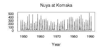
Nuya at Komaka
Lena
| PointID: | 6208 |
Code: | 3155 |
Latitude (decimal degrees): | 60.27 |
Longitude (decimal degrees): | 114.73 |
Drainage Area (km2): | 11700.00 |
Source: | SHI |
Hydrological Zone: | Lena |
Name: | Nuya at Komaka |
Field Definitions
Site Time Series Plot:
Site Data File:
(Units: m3/s)
| ID | Year | Jan | Feb | Mar | Apr | May | Jun | Jul | Aug | Sep | Oct | Nov | Dec |
|---|
| 6208 | 1948 | 2.40 | 1.38 | 1.76 | 3.94 | 311.00 | 67.50 | 16.40 | 12.10 | 19.20 | 10.10 | 3.93 | 2.79 |
| 6208 | 1949 | 1.73 | 1.67 | 1.55 | 2.92 | 315.00 | 72.50 | 22.30 | 11.80 | 17.70 | 17.00 | 5.34 | 3.68 |
| 6208 | 1950 | 2.61 | 1.80 | 1.66 | 2.95 | 260.00 | 96.80 | 81.70 | 11.90 | 6.65 | 5.55 | 2.90 | 3.20 |
| 6208 | 1951 | 2.37 | 1.79 | 2.80 | 4.22 | 223.00 | 90.40 | 51.30 | 20.60 | 38.20 | 17.20 | 8.22 | 4.46 |
| 6208 | 1952 | 3.06 | 2.08 | 1.87 | 3.86 | 424.00 | 77.00 | 27.40 | 54.00 | 11.60 | 31.60 | 11.60 | 6.08 |
| 6208 | 1953 | 2.90 | 1.81 | 2.24 | 12.80 | 488.00 | 60.40 | 37.90 | 31.80 | 35.30 | 16.90 | 6.30 | 3.77 |
| 6208 | 1954 | 2.99 | 2.81 | 2.13 | 1.78 | 201.00 | 214.00 | 39.10 | 13.40 | 12.70 | 12.70 | 4.76 | 2.88 |
| 6208 | 1955 | 2.92 | 2.74 | 2.55 | 2.82 | 484.00 | 119.00 | 20.00 | 12.30 | 7.12 | 2.61 | 2.25 | 2.82 |
| 6208 | 1956 | 2.79 | 3.22 | 3.75 | 3.52 | 229.00 | 213.00 | 81.90 | 14.70 | 34.20 | 26.90 | 5.49 | 3.00 |
| 6208 | 1957 | 1.56 | 0.73 | 0.87 | 1.71 | 271.00 | 44.00 | 41.40 | 21.40 | 32.20 | 54.30 | 7.02 | 5.64 |
| 6208 | 1958 | 3.28 | 1.25 | 2.41 | 4.13 | 494.00 | 116.00 | 27.80 | 9.29 | 7.30 | 5.86 | 4.48 | 4.15 |
| 6208 | 1959 | 2.96 | 2.68 | 2.49 | 2.26 | 260.00 | 330.00 | 9.76 | 10.80 | 17.50 | 9.66 | 3.15 | 2.30 |
| 6208 | 1960 | 1.44 | 1.40 | 1.55 | 0.88 | 449.00 | 153.00 | 39.40 | 17.60 | 35.80 | 12.00 | 3.09 | 2.02 |
| 6208 | 1961 | 1.66 | 1.56 | 1.00 | 1.12 | 336.00 | 93.40 | 48.80 | 13.30 | 4.68 | 3.84 | 2.14 | 1.45 |
| 6208 | 1962 | 1.47 | 1.82 | 2.15 | 2.39 | 348.00 | 280.00 | 24.10 | 7.74 | 8.68 | 5.67 | 3.43 | 3.54 |
| 6208 | 1963 | 3.16 | 2.79 | 3.55 | 3.50 | 356.00 | 235.00 | 18.40 | 9.08 | 10.70 | 10.30 | 5.93 | 3.80 |
| 6208 | 1964 | 3.08 | 3.05 | 2.43 | 1.50 | 309.00 | 81.50 | 62.10 | 7.83 | 6.29 | 5.57 | 2.52 | 2.13 |
| 6208 | 1965 | 1.26 | 1.24 | 1.38 | 1.69 | 156.00 | 66.70 | 27.60 | 7.76 | 8.73 | 9.33 | 3.94 | 2.66 |
| 6208 | 1966 | 2.86 | 2.78 | 2.62 | 3.46 | 284.00 | 51.70 | 23.70 | 4.64 | 6.81 | 4.64 | 2.41 | 2.42 |
| 6208 | 1967 | 2.36 | 2.14 | 1.83 | 33.00 | 245.00 | 50.10 | 20.20 | 55.70 | 37.90 | 14.40 | 4.31 | 2.14 |
| 6208 | 1968 | 1.69 | 1.41 | 1.13 | 18.20 | 257.00 | 62.00 | 65.20 | 12.00 | 11.60 | 5.84 | 2.36 | 1.32 |
| 6208 | 1969 | 0.65 | 0.38 | 0.02 | | 165.00 | 147.00 | 60.90 | 5.00 | 7.58 | 4.10 | 4.54 | 1.10 |
| 6208 | 1970 | 1.24 | 0.71 | 0.32 | 0.36 | 335.00 | 132.00 | 21.30 | 6.65 | 6.43 | 3.47 | 1.72 | 1.14 |
| 6208 | 1971 | 1.02 | 0.48 | 0.15 | 1.32 | 206.00 | 60.60 | 4.98 | 5.00 | 42.90 | 17.30 | 4.54 | 2.43 |
| 6208 | 1972 | 1.88 | 1.46 | 1.78 | 1.81 | 268.00 | 125.00 | 11.90 | 6.53 | 6.17 | 5.13 | 2.03 | 1.24 |
| 6208 | 1973 | 1.51 | 1.50 | 1.47 | 1.26 | 287.00 | 49.20 | 123.00 | 49.00 | 9.86 | 5.66 | 2.83 | 2.34 |
| 6208 | 1974 | 1.92 | 1.54 | 1.43 | 1.72 | 323.00 | 166.00 | 49.90 | 11.30 | 11.70 | 9.57 | 3.03 | 2.08 |
| 6208 | 1975 | 1.91 | 1.63 | 1.82 | 5.04 | 3.40 | 40.00 | 17.50 | 21.10 | 26.30 | 28.60 | 3.95 | 3.99 |
| 6208 | 1976 | 3.04 | 1.87 | 1.87 | 3.08 | 335.00 | 147.00 | 31.50 | 14.80 | 17.00 | 8.50 | 2.19 | 2.02 |
| 6208 | 1977 | 2.00 | 1.60 | 1.51 | 2.12 | 393.00 | 153.00 | 55.40 | 9.25 | 12.60 | 8.57 | 4.49 | 3.50 |
| 6208 | 1978 | 2.98 | 2.14 | 1.98 | 3.50 | 411.00 | 311.00 | 54.40 | 5.96 | 9.72 | 10.00 | 4.68 | 3.32 |
| 6208 | 1979 | 2.74 | 1.33 | 1.58 | 3.66 | 395.00 | 94.70 | 12.60 | 4.63 | 6.04 | 6.21 | 3.92 | 3.35 |
| 6208 | 1980 | 2.77 | 2.70 | 2.79 | 3.35 | 282.00 | 231.00 | 13.70 | 10.50 | 13.00 | 11.50 | 4.20 | 2.76 |
| 6208 | 1981 | 2.19 | 1.36 | 0.63 | 21.60 | 354.00 | 65.00 | 8.75 | 3.97 | 3.95 | 3.26 | 2.08 | 2.34 |
| 6208 | 1982 | 2.21 | 1.95 | 1.49 | 2.55 | 365.00 | 68.80 | 49.70 | 6.41 | 6.97 | 4.63 | 2.45 | 2.20 |
| 6208 | 1983 | 1.88 | 1.49 | 1.63 | 1.84 | 425.00 | 281.00 | 54.00 | 25.80 | 85.80 | 21.90 | 8.56 | 4.21 |
| 6208 | 1984 | 2.89 | 2.10 | 1.71 | 2.22 | 475.00 | 93.50 | 11.60 | 11.20 | 7.92 | 5.35 | 2.42 | 1.72 |
| 6208 | 1985 | 1.26 | 0.88 | 0.76 | 1.47 | 352.00 | 34.80 | 6.75 | 6.33 | 9.94 | 6.86 | 2.44 | 0.75 |
| 6208 | 1986 | 0.61 | 0.68 | 1.27 | 2.04 | 253.00 | 46.90 | 5.65 | 17.80 | 20.30 | 9.00 | 3.24 | 2.95 |
| 6208 | 1987 | 2.21 | 2.30 | 2.04 | 1.96 | 322.00 | 166.00 | 39.80 | 42.50 | 7.33 | 6.69 | 3.31 | 3.05 |
| 6208 | 1988 | 2.33 | 1.93 | 2.60 | 6.25 | 302.00 | 153.00 | 86.40 | 16.50 | 16.10 | 24.20 | 9.19 | 5.18 |
| 6208 | 1989 | 3.33 | 3.13 | 3.25 | 3.84 | 528.00 | 168.00 | 44.10 | 27.10 | 47.50 | 19.80 | 5.99 | 4.03 |
| 6208 | 1990 | 4.16 | 3.83 | 3.50 | 3.50 | 426.00 | 33.30 | 39.90 | 4.52 | 5.63 | 6.20 | 3.26 | 2.94 |
| Other Close Sites |
|---|
| PointID |
Latitude |
Longitude | Drainage Area | Source |
Name |
|---|
| 6209 | 60.27 | 114.73 | 32600.00 | SHI | Nuya at Kurum |
| 6325 | 60.45 | 114.33 | 23200.00 | SHI | Nuya at Naahara |
 Return to R-Arctic Net Home Page