Chona at Ust'Marhaya
Lena
| PointID: | 6269 |
Code: | 3335 |
Latitude (decimal degrees): | 61.98 |
Longitude (decimal degrees): | 109.75 |
Drainage Area (km2): | 22600.00 |
Source: | SHI |
Hydrological Zone: | Lena |
Name: | Chona at Ust'Marhaya |
Field Definitions
Site Time Series Plot:
Site Data File:
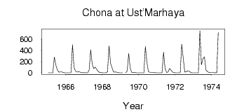
(Units: m3/s)
| ID | Year | Jan | Feb | Mar | Apr | May | Jun | Jul | Aug | Sep | Oct | Nov | Dec |
|---|
| 6269 | 1965 | 1.18 | 0.75 | 0.71 | 0.85 | 283.00 | 138.00 | 53.30 | 13.10 | 15.70 | 16.60 | 4.23 | 1.09 |
| 6269 | 1966 | 0.44 | 0.41 | 0.22 | 0.39 | 502.00 | 94.70 | 31.10 | 11.80 | 21.10 | 12.80 | 2.55 | 2.42 |
| 6269 | 1967 | 2.57 | 1.64 | 1.55 | 52.50 | 412.00 | 161.00 | 77.40 | 104.00 | 58.60 | 21.30 | 5.74 | 3.24 |
| 6269 | 1968 | 2.41 | 1.44 | 1.41 | 19.00 | 481.00 | 172.00 | 90.00 | 12.10 | 16.70 | 13.20 | 4.36 | 1.19 |
| 6269 | 1969 | 0.48 | 2.0e-03 | | 0.02 | 35.20 | 347.00 | 82.50 | 6.68 | 9.41 | 6.93 | 2.35 | 1.69 |
| 6269 | 1970 | 1.20 | 0.96 | 0.63 | 1.70 | 472.00 | 189.00 | 20.90 | 11.40 | 10.50 | 9.20 | 3.04 | 1.96 |
| 6269 | 1971 | 1.38 | 0.94 | 0.55 | 0.66 | 369.00 | 79.50 | 6.16 | 15.80 | 79.10 | 47.40 | 11.60 | 4.01 |
| 6269 | 1972 | 2.42 | 1.30 | 1.38 | 1.79 | 512.00 | 266.00 | 13.00 | 19.80 | 36.80 | 28.10 | 2.71 | 2.05 |
| 6269 | 1973 | 2.08 | 1.48 | 1.48 | 1.60 | 752.00 | 143.00 | 254.00 | 286.00 | 49.50 | 20.80 | 6.13 | 4.12 |
| 6269 | 1974 | 4.01 | 3.18 | 1.90 | 2.53 | 722.00 | | | | | | | |
| Other Close Sites |
|---|
| PointID |
Latitude |
Longitude | Drainage Area | Source |
Name |
|---|
| 6268 | 61.90 | 109.58 | 21000.00 | SHI | Chona at Chona |
 Return to R-Arctic Net Home Page