Chona at Chona
Lena
| PointID: | 6268 |
Code: | 3334 |
Latitude (decimal degrees): | 61.90 |
Longitude (decimal degrees): | 109.58 |
Drainage Area (km2): | 21000.00 |
Source: | SHI |
Hydrological Zone: | Lena |
Name: | Chona at Chona |
Field Definitions
Site Time Series Plot:
Site Data File:
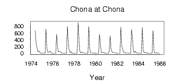
(Units: m3/s)
| ID | Year | Jan | Feb | Mar | Apr | May | Jun | Jul | Aug | Sep | Oct | Nov | Dec |
|---|
| 6268 | 1974 | | | | | 663.00 | 295.00 | 156.00 | 47.10 | 66.30 | 41.60 | 5.83 | 5.09 |
| 6268 | 1975 | 2.62 | 1.48 | 1.40 | 12.60 | 718.00 | 172.00 | 26.00 | 33.30 | 55.00 | 61.30 | 6.10 | 2.98 |
| 6268 | 1976 | 3.70 | 2.90 | 2.13 | 2.68 | 559.00 | 175.00 | 41.50 | 55.10 | 54.00 | 31.60 | 4.01 | 3.32 |
| 6268 | 1977 | 1.51 | 1.32 | 2.17 | 2.68 | 796.00 | 294.00 | 102.00 | 23.50 | 52.60 | 2.36 | 8.42 | 3.78 |
| 6268 | 1978 | 2.60 | 1.88 | 2.47 | 4.81 | 908.00 | 419.00 | 68.50 | 12.70 | 35.00 | 30.30 | 10.40 | 3.96 |
| 6268 | 1979 | 2.64 | 2.07 | 1.71 | 4.31 | 790.00 | 156.00 | 16.60 | 10.40 | 12.80 | 13.50 | 3.69 | 4.22 |
| 6268 | 1980 | 2.64 | 1.69 | 1.64 | 2.88 | 560.00 | 296.00 | 21.80 | 20.80 | 30.40 | 27.90 | 7.32 | 3.44 |
| 6268 | 1981 | 2.08 | 1.48 | 1.31 | 76.10 | 513.00 | 136.00 | 42.90 | 22.10 | 21.50 | 19.10 | 7.49 | 4.24 |
| 6268 | 1982 | 2.74 | 2.16 | 2.08 | 11.20 | 774.00 | 202.00 | 116.00 | 31.80 | 35.30 | 19.20 | 7.35 | 5.32 |
| 6268 | 1983 | 4.97 | 4.09 | 3.67 | 3.72 | 699.00 | 427.00 | 61.50 | 22.00 | 68.60 | 26.80 | 10.80 | 6.81 |
| 6268 | 1984 | 4.79 | 2.27 | 2.49 | 2.18 | 761.00 | 100.00 | 24.80 | 30.40 | 21.80 | 14.70 | 4.78 | 3.63 |
| 6268 | 1985 | 2.94 | 2.67 | 1.16 | 8.21 | 671.00 | 74.00 | 11.80 | 9.66 | 20.50 | 13.40 | 6.06 | 2.22 |
| Other Close Sites |
|---|
| PointID |
Latitude |
Longitude | Drainage Area | Source |
Name |
|---|
| 6269 | 61.98 | 109.75 | 22600.00 | SHI | Chona at Ust'Marhaya |
 Return to R-Arctic Net Home Page