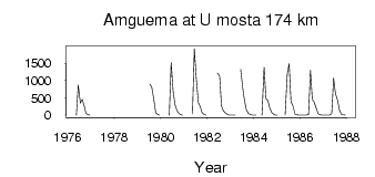
| PointID: | 5942 | Code: | 1594 | Latitude (decimal degrees): | 67.42 | Longitude (decimal degrees): | 178.40 | Drainage Area (km2): | 26400.00 | Source: | SHI | Hydrological Zone: | Anadyr Kolyma | Name: | Amguema at U mosta 174 km |
|---|
| Download | |
|---|---|
| Site Descriptor Information | Site Time Series Data |
| Link to all available data | |
| ID | Year | Jan | Feb | Mar | Apr | May | Jun | Jul | Aug | Sep | Oct | Nov | Dec |
|---|---|---|---|---|---|---|---|---|---|---|---|---|---|
| 5942 | 1976 | 0.17 | 870.00 | 350.00 | 451.00 | 279.00 | 53.00 | 13.40 | 5.20 | ||||
| 5942 | 1979 | 893.00 | 817.00 | 436.00 | 75.20 | 14.90 | 0.29 | ||||||
| 5942 | 1980 | 4.73 | 1520.00 | 713.00 | 313.00 | 124.00 | 49.30 | 8.44 | 0.07 | ||||
| 5942 | 1981 | 31.30 | 1920.00 | 1080.00 | 363.00 | 245.00 | 70.30 | 18.50 | 0.77 | ||||
| 5942 | 1982 | 1210.00 | 1130.00 | 263.00 | 127.00 | 67.90 | 20.80 | 3.27 | |||||
| 5942 | 1983 | 1.72 | 0.96 | 0.17 | 1330.00 | 769.00 | 392.00 | 137.00 | 50.50 | 14.60 | 2.70 | ||
| 5942 | 1984 | 0.08 | 3.0e-03 | 0.87 | 1380.00 | 475.00 | 420.00 | 213.00 | 71.30 | 26.80 | 6.18 | ||
| 5942 | 1985 | 1.21 | 1.31 | 1180.00 | 1480.00 | 383.00 | 277.00 | 36.60 | 11.50 | 5.14 | |||
| 5942 | 1986 | 1.00 | 0.00 | 0.00 | 0.00 | 18.30 | 1300.00 | 455.00 | 379.00 | 197.00 | 37.90 | 11.90 | 3.50 |
| 5942 | 1987 | 0.08 | 0.00 | 0.00 | 0.00 | 38.10 | 1070.00 | 626.00 | 426.00 | 150.00 | 27.20 | 12.50 | 0.45 |
| Other Close Sites | ||||||
|---|---|---|---|---|---|---|
| PointID | Latitude | Longitude | Drainage Area | Source | Name | |
| 5914 | 67.46 | 178.22 | 26700.00 | SHI | Amguema at Ust'e Shumny | |
 Return to R-Arctic Net Home Page