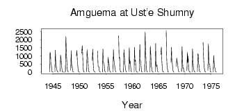
| PointID: | 5914 | Code: | 1492 | Latitude (decimal degrees): | 67.46 | Longitude (decimal degrees): | 178.22 | Drainage Area (km2): | 26700.00 | Source: | SHI | Hydrological Zone: | Anadyr Kolyma | Name: | Amguema at Ust'e Shumny |
|---|
| Download | |
|---|---|
| Site Descriptor Information | Site Time Series Data |
| Link to all available data | |
| ID | Year | Jan | Feb | Mar | Apr | May | Jun | Jul | Aug | Sep | Oct | Nov | Dec |
|---|---|---|---|---|---|---|---|---|---|---|---|---|---|
| 5914 | 1944 | 0.34 | 14.90 | 1230.00 | 1110.00 | 482.00 | 431.00 | 71.10 | 22.70 | 3.38 | |||
| 5914 | 1945 | 0.94 | 6.0e-03 | 9.77 | 1350.00 | 659.00 | 387.00 | 171.00 | 103.00 | 18.70 | 4.19 | ||
| 5914 | 1946 | 0.93 | 46.30 | 1040.00 | 819.00 | 416.00 | 216.00 | 31.80 | 13.60 | 6.02 | |||
| 5914 | 1947 | 0.35 | 5.0e-03 | 1.0e-03 | 1.11 | 2190.00 | 1170.00 | 820.00 | 212.00 | 67.60 | 12.20 | 0.99 | |
| 5914 | 1948 | 119.00 | 1320.00 | 461.00 | 398.00 | 152.00 | 31.50 | 10.70 | 2.64 | ||||
| 5914 | 1949 | 991.00 | 1330.00 | 626.00 | 453.00 | 46.60 | 14.30 | 1.97 | |||||
| 5914 | 1950 | 0.28 | 1.0e-03 | 1170.00 | 1630.00 | 1290.00 | 299.00 | 48.10 | 15.50 | 6.04 | |||
| 5914 | 1951 | 6.48 | 1380.00 | 1000.00 | 792.00 | 172.00 | 41.30 | 18.40 | 2.21 | ||||
| 5914 | 1952 | 722.00 | 1410.00 | 476.00 | 140.00 | 49.80 | 18.80 | 4.15 | |||||
| 5914 | 1953 | 0.06 | 1290.00 | 380.00 | 333.00 | 325.00 | 86.60 | 34.90 | 5.82 | ||||
| 5914 | 1954 | 0.26 | 2.32 | 1420.00 | 688.00 | 524.00 | 505.00 | 94.30 | 32.20 | 6.91 | |||
| 5914 | 1955 | 0.34 | 0.01 | 913.00 | 588.00 | 551.00 | 211.00 | 33.30 | 4.42 | 0.83 | |||
| 5914 | 1956 | 0.10 | 0.11 | 1380.00 | 854.00 | 563.00 | 349.00 | 137.00 | 49.00 | 0.36 | |||
| 5914 | 1957 | 2240.00 | 864.00 | 911.00 | 216.00 | 36.80 | 14.50 | 3.83 | |||||
| 5914 | 1958 | 0.13 | 0.25 | 1380.00 | 861.00 | 583.00 | 302.00 | 92.00 | 19.40 | 3.24 | |||
| 5914 | 1959 | 29.30 | 1510.00 | 513.00 | 685.00 | 360.00 | 123.00 | 14.80 | 2.26 | ||||
| 5914 | 1960 | 0.08 | 1530.00 | 664.00 | 742.00 | 280.00 | 43.40 | 16.10 | 3.68 | ||||
| 5914 | 1961 | 1.62 | 0.07 | 70.90 | 1700.00 | 759.00 | 646.00 | 294.00 | 49.10 | 14.00 | 1.84 | ||
| 5914 | 1962 | 1.18 | 2460.00 | 1550.00 | 775.00 | 231.00 | 58.00 | 15.00 | 3.00 | ||||
| 5914 | 1963 | 0.50 | 1600.00 | 1060.00 | 469.00 | 270.00 | 57.00 | 16.00 | 3.50 | ||||
| 5914 | 1964 | 0.27 | 20.50 | 1760.00 | 493.00 | 326.00 | 465.00 | 93.60 | 33.10 | 6.63 | |||
| 5914 | 1965 | 0.08 | 1100.00 | 1540.00 | 702.00 | 358.00 | 51.60 | 13.40 | 3.41 | ||||
| 5914 | 1966 | 0.12 | 2560.00 | 921.00 | 412.00 | 187.00 | 25.50 | 5.89 | 1.06 | ||||
| 5914 | 1967 | 605.00 | 1540.00 | 644.00 | 513.00 | 132.00 | 49.40 | 8.00 | 0.25 | ||||
| 5914 | 1968 | 347.00 | 864.00 | 658.00 | 522.00 | 239.00 | 59.70 | 13.20 | 0.54 | ||||
| 5914 | 1969 | 36.40 | 1570.00 | 795.00 | 234.00 | 277.00 | 46.80 | 15.10 | 3.61 | ||||
| 5914 | 1970 | 0.37 | 80.50 | 1230.00 | 580.00 | 990.00 | 299.00 | 72.10 | 20.30 | 4.83 | |||
| 5914 | 1971 | 2.09 | 0.12 | 0.03 | 1420.00 | 632.00 | 334.00 | 117.00 | 33.00 | 14.30 | 2.34 | ||
| 5914 | 1972 | 17.50 | 1140.00 | 1100.00 | 479.00 | 431.00 | 37.70 | 21.80 | 3.82 | ||||
| 5914 | 1973 | 1820.00 | 938.00 | 336.00 | 236.00 | 50.20 | 19.90 | 4.03 | |||||
| 5914 | 1974 | 104.00 | 1740.00 | 684.00 | 482.00 | 489.00 | 78.00 | 24.20 | 7.18 | ||||
| 5914 | 1975 | 0.56 | 0.01 | 1020.00 | 644.00 | 303.00 | 243.00 | 60.40 | 14.40 | 2.71 |
| Other Close Sites | ||||||
|---|---|---|---|---|---|---|
| PointID | Latitude | Longitude | Drainage Area | Source | Name | |
| 5942 | 67.42 | 178.40 | 26400.00 | SHI | Amguema at U mosta 174 km | |
 Return to R-Arctic Net Home Page