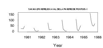
| PointID: | 5128 | Code: | 03DE003 | Latitude (decimal degrees): | 53.25 | Longitude (decimal degrees): | -74.79 | Drainage Area (km2): | 13800.00 | Source: | Hydat | Hydrological Zone: | South and East Hudson Bay | Name: | SAKAMI (RIVIERE) EN AVAL DE LA RIVIERE DE PONTOIS-1 |
|---|
| Download | |
|---|---|
| Site Descriptor Information | Site Time Series Data |
| Link to all available data | |
| ID | Year | Jan | Feb | Mar | Apr | May | Jun | Jul | Aug | Sep | Oct | Nov | Dec |
|---|---|---|---|---|---|---|---|---|---|---|---|---|---|
| 5128 | 1960 | 22.00 | 23.70 | 21.80 | 45.20 | ||||||||
| 5128 | 1961 | 29.10 | 6.65 | 0.59 | 0.25 | 5.50 | |||||||
| 5128 | 1962 | 74.20 | 12.30 | 14.50 | 17.30 | ||||||||
| 5128 | 1963 | 100.00 | 18.90 | 9.28 | 0.62 | 1.48 | |||||||
| 5128 | 1964 | 107.00 | 13.80 | 3.35 | 27.00 | 49.60 | |||||||
| 5128 | 1965 | 160.00 | 86.70 | 50.80 | 45.80 | 67.40 |
| Other Close Sites | ||||||
|---|---|---|---|---|---|---|
| PointID | Latitude | Longitude | Drainage Area | Source | Name | |
| 5121 | 53.25 | -74.62 | 13800.00 | Hydat | MASTA (CHENAL) EN AVAL DE LA RIVIERE DE PONTOIS | |
| 5122 | 53.16 | -74.47 | 13200.00 | Hydat | DE PONTOIS (RIVIERE) EN AMONT DE LA RIVIERE SAKAMI | |
| 5124 | 53.24 | -74.63 | 13800.00 | Hydat | MASTA (CHENAL) EN AVAL DE LA RIVIERE DE PONTOIS-1 | |
| 5125 | 53.28 | -74.74 | 13800.00 | Hydat | DE PONTOIS (RIVIERE) EN AVAL DE LA RIVIERE SAKAMI | |
| 5129 | 53.25 | -74.79 | 13800.00 | Hydat | SAKAMI (RIVIERE) EN AVAL DE LA RIVIERE DE PONTOIS-2 | |
| 5130 | 53.16 | -74.82 | 13800.00 | Hydat | FREGATE (LAC DE LA) | |
 Return to R-Arctic Net Home Page