| PointID: | 5121 | Code: | 03DD001 | Latitude (decimal degrees): | 53.25 | Longitude (decimal degrees): | -74.62 | Drainage Area (km2): | 13800.00 | Source: | Hydat | Hydrological Zone: | South and East Hudson Bay | Name: | MASTA (CHENAL) EN AVAL DE LA RIVIERE DE PONTOIS |
|---|
| Download | |
|---|---|
| Site Descriptor Information | Site Time Series Data |
| Link to all available data | |
| ID | Year | Jan | Feb | Mar | Apr | May | Jun | Jul | Aug | Sep | Oct | Nov | Dec |
|---|---|---|---|---|---|---|---|---|---|---|---|---|---|
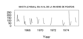
| 5121 | 1966 | 77.80 | 208.00 | 81.20 | 118.00 | 98.00 | 79.00 | ||||||
| 5121 | 1967 | 188.00 | 30.50 | 84.20 | 28.20 | 10.10 | |||||||
| 5121 | 1968 | 143.00 | 35.80 | 25.20 | 135.00 | 65.10 | 54.50 | ||||||
| 5121 | 1969 | 162.00 | 134.00 | 38.20 | 52.20 | 120.00 | |||||||
| 5121 | 1970 | 145.00 | 47.80 | 36.10 | 38.10 | ||||||||
| 5121 | 1971 | 9.92 | 27.00 | 57.60 | 152.00 | ||||||||
| 5121 | 1972 | 60.80 | |||||||||||
| 5121 | 1973 | 106.00 | 22.50 | 6.36 | 34.10 | 59.60 | |||||||
| 5121 | 1974 | 282.00 | 54.10 | 8.81 | 22.80 | 80.00 | |||||||
| 5121 | 1975 | 154.00 | 73.60 | 66.40 |
| Other Close Sites | ||||||
|---|---|---|---|---|---|---|
| PointID | Latitude | Longitude | Drainage Area | Source | Name | |
| 5122 | 53.16 | -74.47 | 13200.00 | Hydat | DE PONTOIS (RIVIERE) EN AMONT DE LA RIVIERE SAKAMI | |
| 5124 | 53.24 | -74.63 | 13800.00 | Hydat | MASTA (CHENAL) EN AVAL DE LA RIVIERE DE PONTOIS-1 | |
| 5125 | 53.28 | -74.74 | 13800.00 | Hydat | DE PONTOIS (RIVIERE) EN AVAL DE LA RIVIERE SAKAMI | |
| 5128 | 53.25 | -74.79 | 13800.00 | Hydat | SAKAMI (RIVIERE) EN AVAL DE LA RIVIERE DE PONTOIS-1 | |
| 5129 | 53.25 | -74.79 | 13800.00 | Hydat | SAKAMI (RIVIERE) EN AVAL DE LA RIVIERE DE PONTOIS-2 | |
| 5130 | 53.16 | -74.82 | 13800.00 | Hydat | FREGATE (LAC DE LA) | |
 Return to R-Arctic Net Home Page