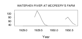
| PointID: | 2813 | Code: | 05LH004 | Latitude (decimal degrees): | 51.83 | Longitude (decimal degrees): | -99.55 | Drainage Area (km2): | 55100.00 | Source: | Hydat | Hydrological Zone: | Nelson | Name: | WATERHEN RIVER AT MCCREERY'S FARM |
|---|
| Download | |
|---|---|
| Site Descriptor Information | Site Time Series Data |
| Link to all available data | |
| ID | Year | Jan | Feb | Mar | Apr | May | Jun | Jul | Aug | Sep | Oct | Nov | Dec |
|---|---|---|---|---|---|---|---|---|---|---|---|---|---|
| 2813 | 1928 | 94.30 | |||||||||||
| 2813 | 1929 | 80.80 | 115.00 | 91.70 | 61.20 | 40.50 | 37.40 | ||||||
| 2813 | 1930 | 69.80 | 80.90 | 63.50 | 47.30 | 40.50 |
| Other Close Sites | ||||||
|---|---|---|---|---|---|---|
| PointID | Latitude | Longitude | Drainage Area | Source | Name | |
| 2812 | 51.81 | -99.53 | 55100.00 | Hydat | WATERHEN RIVER AT BERNARDIN'S FARM | |
| 2814 | 51.85 | -99.54 | 55000.00 | Hydat | WATERHEN RIVER NEAR WATERHEN | |
 Return to R-Arctic Net Home Page