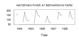
| PointID: | 2812 | Code: | 05LH002 | Latitude (decimal degrees): | 51.81 | Longitude (decimal degrees): | -99.53 | Drainage Area (km2): | 55100.00 | Source: | Hydat | Hydrological Zone: | Nelson | Name: | WATERHEN RIVER AT BERNARDIN'S FARM |
|---|
| Download | |
|---|---|
| Site Descriptor Information | Site Time Series Data |
| Link to all available data | |
| ID | Year | Jan | Feb | Mar | Apr | May | Jun | Jul | Aug | Sep | Oct | Nov | Dec |
|---|---|---|---|---|---|---|---|---|---|---|---|---|---|
| 2812 | 1923 | 156.00 | 154.00 | 158.00 | |||||||||
| 2812 | 1924 | 75.00 | 109.00 | 185.00 | 134.00 | 103.00 | 89.50 | 93.30 | 94.00 | ||||
| 2812 | 1925 | 53.00 | 128.00 | 204.00 | 182.00 | 151.00 | 148.00 | 127.00 | |||||
| 2812 | 1926 | 70.00 | 101.00 | 142.00 | 97.40 | 76.00 | 68.40 | 64.90 | |||||
| 2812 | 1927 | 104.00 | 182.00 | 177.00 | 148.00 | 152.00 | 152.00 | ||||||
| 2812 | 1928 | 126.00 | 194.00 | 157.00 | 124.00 | 104.00 |
| Other Close Sites | ||||||
|---|---|---|---|---|---|---|
| PointID | Latitude | Longitude | Drainage Area | Source | Name | |
| 2813 | 51.83 | -99.55 | 55100.00 | Hydat | WATERHEN RIVER AT MCCREERY'S FARM | |
| 2814 | 51.85 | -99.54 | 55000.00 | Hydat | WATERHEN RIVER NEAR WATERHEN | |
 Return to R-Arctic Net Home Page