|
|
|||||||||||||||||
| Point ID: 8796 | Downloads | Plots | Site Data | Code: 12258 |
|
|
|||||||||||||||||
| Download | |
|---|---|
| Site Descriptor Information | Site Time Series Data |
| Link to all available data | |
| View: | Time Series | All |
| Units: | mm |
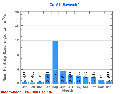
| Statistic | Jan | Feb | Mar | Apr | May | Jun | Jul | Aug | Sep | Oct | Nov | Dec | Annual |
|---|---|---|---|---|---|---|---|---|---|---|---|---|---|
| Mean | 0.49 | 0.40 | 0.45 | 2.66 | 11.77 | 3.64 | 2.46 | 2.09 | 1.85 | 1.81 | 1.10 | 0.65 | 2.59 |
| Standard Deviation | 0.18 | 0.15 | 0.18 | 2.11 | 6.08 | 2.27 | 2.05 | 2.25 | 1.59 | 1.39 | 0.51 | 0.26 | 0.88 |
| Min | 0.18 | 0.16 | 0.19 | 0.38 | 4.10 | 1.50 | 0.59 | 0.24 | 0.19 | 0.63 | 0.32 | 0.25 | 1.40 |
| Max | 0.73 | 0.67 | 0.79 | 7.61 | 20.70 | 9.68 | 6.36 | 9.50 | 6.09 | 5.02 | 1.92 | 1.06 | 4.11 |
| Coefficient of Variation | 0.37 | 0.36 | 0.40 | 0.79 | 0.52 | 0.62 | 0.83 | 1.08 | 0.86 | 0.77 | 0.46 | 0.40 | 0.34 |
 Return to R-Arctic Net Home Page